Refine your search
Sale Section
Estimate
Category
- Books, Manuscripts & Periodicals (202)
- Maps (47)
- Prints & Multiples (22)
- Watercolours (6)
- Arms, Armour & Militaria (3)
- Oil, Acrylic paintings & Mixed Media (3)
- Collectables (2)
- Drawings & Pastels (2)
- Photographs (2)
- Sculpture (2)
- Toys, Models & Dolls (2)
- Chinese Works of Art (1)
- Coins (1)
- Ethnographica & tribal art (1)
- Scientific Instruments (1)
Creator / Brand
- Blaeu (6)
- Ortelius (5)
- J. R. R. Tolkien (3)
- Charles Dickens (2)
- Janssonius (2)
- John Speed (2)
- Rudyard Kipling (2)
- Second World War (2)
- Arnold Floris van Langren (1)
- Arthur Conan Doyle (1)
- Chaucer (1)
- Eric Gill (1)
- Franz Kafka (1)
- Deutsch (1)
- Goya (1)
- Graham Greene (1)
- James Joyce (1)
- James Mcbey (1)
- Laurence Sterne (1)
- Lucas Cranach The Elder (1)
- Marvel (1)
- Mercator (1)
- Myles Birket Foster (1)
- Odhams Press (1)
- Sylvia Plath (1)
- Thomas Hardy (1)
- Tibetan (1)
- Van Keulen (1)
- Virginia Woolf (1)
- William Blake (1)
- William Shakespeare (1)
Item Type
- Book (64)
- Folio (29)
- Map (20)
- Letter (13)
- Famous Author (11)
- Cartographers and Mapmakers (7)
- Poetry (6)
- Manuscript (5)
- 15th-18th Century Art (3)
- Bible (3)
- Etching (3)
- Guide book (3)
- Journal (3)
- 19th-21st Century Art (2)
- Lithograph (2)
- Magazine (2)
- Manual (2)
- Militaria (2)
- Ordnance survey map (2)
- Periodical (2)
- Photograph album (2)
- Portrait (2)
- Road map (2)
- WW2 Militaria (2)
- Advertising (1)
- Anthony Trollope (1)
- Arthur Conan Doyle (1)
- Atlas (1)
- Comic book (1)
- Dictionary (1)
- Drypoint (1)
- Engraving (1)
- Figure (1)
- Landscape (1)
- Modern & Impressionist Art (1)
- Portrait Painting (1)
- Programme (1)
- Programmes (1)
- List
- Grid
Results for live webcast and timed auctions may not have been verified by the auctioneer. If you are in any doubt of the accuracy of the prices provided, please call the auction house to confirm.
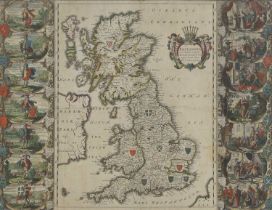

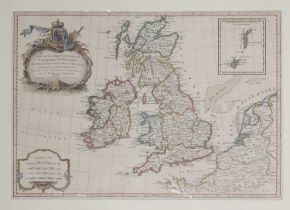
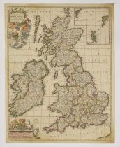
JANVIER, Jean:
JANVIER, Jean: Les Isles Britanniques Comprenant les Royaumes d'Angleterre d'Ecosse et d'Irlande. c.1762, hand-coloured and mounted. 44 x 31cm; Bo...
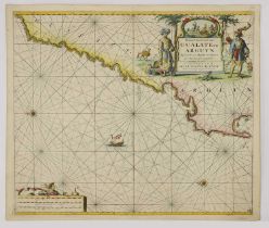
SEA CHART:
SEA CHART: Van Keulen: Paskaart van't Canaal Engelandt Schotlandt en Yrland. c.1708. 58 x 50cm; Bellin: Carte Reduite des Mers du Nord {North Atla...
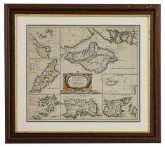
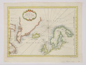
Morden: Robert:
Morden: Robert: The smaller Islands in the British Ocean (The Isle of Wight, Alderney, Guernsey, Jersey, Scilly, Isle of Man, Holy Island and Farn...
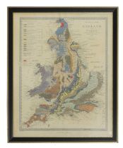
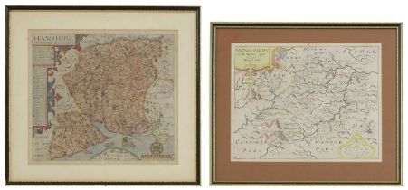
Walker (J & C):
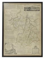
Walker (J & C): A Geological Map of England and Wales. Published by Charles Knight for the SDUK, 1843. Hand-coloured, mounted, framed and glazed ...
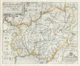
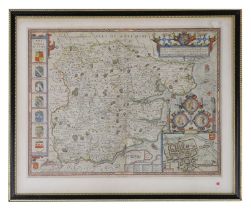
WALES: Blaeu:
WALES: Blaeu: Penbrochia Comitatus et Comitatus Caermaridunum. Amsterdam, c.1662. Hand-coloured, mounted, framed and glazed, 41 x 53cm; Saxton: C...
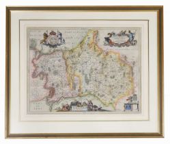
SPEED, John:
SPEED, John: Kent with Her Cities and Earles described and observed, hand-coloured, mounted, framed and glazed front and rear, c.167637 x 49cm Con...
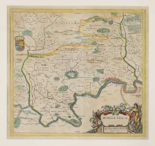
Blaeu, J:
Blaeu, J: Middle-Sexia. Amsterdam, c.1662, Latin text, hand-coloured, 39 x 37cm
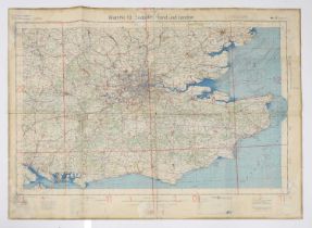
16 Second World War Maps of England, Wales & Scotland, German Luftwaffe. Large folding coloured maps, in German (16)
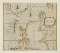
SCOTLAND (2 sheets):
SCOTLAND (2 sheets): CORONELLI, VM: Scotia, parte meridonale; Scotia, parte settentionale, Venice, c.1690. Double-page engraved map of Scotland on...
SCOTLAND (2 Maps):
SCOTLAND (2 Maps): DE WIT, F: Novissima prae caeteris aliis accuratissima Regnorum Angliae, Scotiae, Hiberniae, Amsterdam, c.1690. Hand-coloured e...
SCOTLAND (4 Maps):
SCOTLAND (4 Maps): Collins, Captain Greenvile: The East Coast of Scotland with the Isles of Orkney and Shetland. c.1693, hand-coloured and mounted...
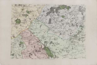
Collection of Maps
Collection of Maps including: Hertfordshire, 1840 and c.1880; Devonshire, c.1748; Cambridgeshire, c.1818; Bedfordshire; Isle of Thanet, c.1850; Bo...
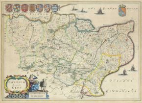
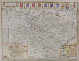
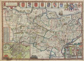
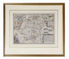
KENT: Jansson, J:
KENT: Jansson, J: Cantium vernacule. Amsterdam, c.1650, hand-coloured, mounted, framed and glazed, 39 x 53cm
GREENWOOD, C & J:
GREENWOOD, C & J: Map of the County of Kent from an actual survey made in the years 1819 & 1820. 1829, hand-coloured, mounted, framed and glazedPl...
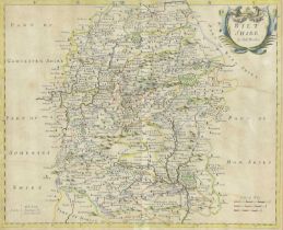
Morden, Robert:
Morden, Robert: Wiltshire. Sold by Abel Swale & John Churchil, c.1722. Hand-coloured, mounted, framed and glazed, 34 x 41cm; Blaeu: (Somerset) Som...
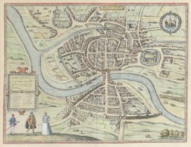
Braun, Georg & Frans Hogenberg: Brighstowe vulgo quondam venta (Bristol City Plan). c.1581 or later, hand-coloured, mounted, framed and glazed, 34...
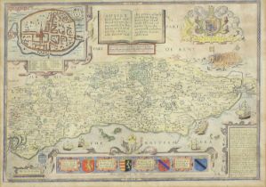
Speed, John & Norden, John:
Speed, John & Norden, John: Sussex Described and divided into Rapes with the siutuation of Chichester the cheife citie thereof. And the armes of s...
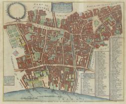
Stow, John:
Stow, John: Farrington Ward without its Division into parishes taken from the last survey. c.1754. Hand-coloured, mounted, framed and glazed, 29 x...
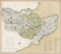
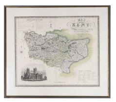
Smith, C:
Smith, C: A New Map of the County of Kent Divided into Lathes &c. c.1804. Hand-coloured, mounted, framed and glazed, 44 x 49cm
![[DRAYTON, Michael]:](https://portal-images.azureedge.net/auctions-2024/sworde1-10059/images/e2010f3e-685e-4235-9c28-b15601140675.jpg?h=210)
[DRAYTON, Michael]:
[DRAYTON, Michael]: KENT. c.1622. Hand-coloured, mounted, framed and glazed, 25 x 32cm
Speed, J:
Speed, J: Kent with her cities and Earles described & observed. Bassett & Chiswell (?), c.1676, hand-coloured, mounted, framed and glazed, 37 x 5...
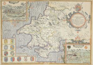
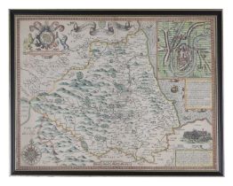
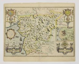
Speed, J:
Speed, J: Penbrokshyre described and the Situations both of Penbroke and St. Davids shewed in due form, c.1676, hand-coloured, mounted, framed an...
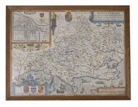
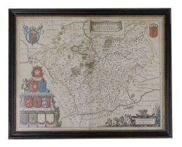
SPEED, John: Dorsetshyre
SPEED, John: Dorsetshyre With the Shyre towne Dorcester described, as also the Armes of such noble families as have bene honored with the Titles t...
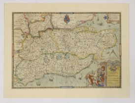
SPEED, John:
SPEED, John: Essex, devided into Hundreds, with the most antient and fayre Towne Colchester Described and other memorable Monuments observed. Anno...
SPEED, John:
SPEED, John: The Bishopric and Citie of Durham. c.1612, hand-coloured, mounted, framed and glazed front and rear, 38 x 60cm
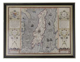
SPEED, John:
SPEED, John: The Isle of Man Exactly described...Described by Tho. Durham Ano. 1595, performed by John Speed Anno 1610. [1676], Bassett & Chiswell...
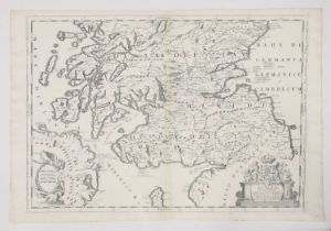
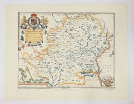
Blaeu, J:
Blaeu, J: Leicestrensis Comitatus. Leicester Shire, Amsterdam, c.1645, (Dutch text to rear). Hand-coloured, mounted, framed and glazed front and r...
Bowen, E:
Bowen, E: An Accurate map of Cambridgeshire divided into its hundreds. c.1760. Mounted, framed and glazed. Glass broken, 52 x 70cm.; Morden, Rober...
WALES (4 Maps):
WALES (4 Maps): SPEED, John: Merionethshire Described 1610. Hand-coloured, 50 x 38cm; Flint shire, c.1610. Hand-coloured, 50 x 38cm; Montgomery Sh...
SMITH, C:
SMITH, C: A NEW MAP of the COUNTY of STAFFORD Divided into Hundreds.1804. Hand-coloured 42 x 48cm; A New Map of the County of Berks, divided into ...
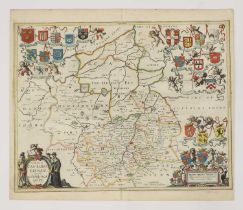
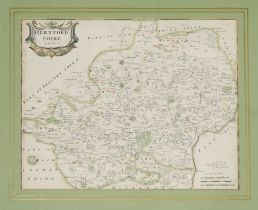
Jansson:
Jansson: Comitatis Cantabrigiensis vernacule Cambridgeshire, Amsterdam, c.1650. Hand-coloured, 51 x 41cm; Middelsexiae, cum Hertfordiae, Comitatu ...
Blaeu, J:
Blaeu, J: Oxonium Comitatus, vulgo Oxfordshire. Amsterdam, c.1662, hand-coloured, 50 x 38cm. Light damp stain to bottom margin; backed on to thick...
SPEED, John:
SPEED, John: SHROPSHYRE DESCRIBED Shropshire. c.1649, hand-coloured. 51 x 38cm: Shrowesbury Described the sittuation of Shrowesbury Shewed, Basset...
The FENS:
The FENS: Jansson, J: A general Plott and description of the Fennes and surrounded grounds in the sixe counties of Norfolke, Suffolke, Cambridge, ...
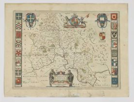
SPEED, J:
SPEED, J: Hartfordshire Described. The sittuations of Hartford and the most ancient towne S Albons with such memorable actions as have happened. J...
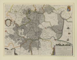
Jansson, J:
Jansson, J: Middelsexiae cum Hertfordiae comitatu (Middlesex & Hertfordshire). Amsterdam, c.1650. Mounted, framed and glazed, 44.5 x 59.5cm
Collection of MAPS,
Collection of MAPS, Hand-coloured, mounted, framed and glazed: Morden: Somersetshire; Ogilby (3 maps): The road from Exeter to Dorchester; From Da...
CHAPMAN, John & Peter ANDRE:
CHAPMAN, John & Peter ANDRE: A Map of the County of Essex from an Actual Survey taken in MDCCLXXII, LXXIII and MDCCLXXIV, Title page dated 1777, ...
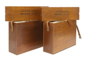
Ordnance Survey of Scotland:
Ordnance Survey of Scotland: Complete set. 92 colour maps, each dissected into 4 sections laid on linen, with numbering tabs, preserved in the pub...
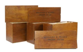
Ordnance Survey of England and Wales: Complete set of the 7th Series. 190 one-inch colour maps, each dissected into 6 sections laid on linen, wit...
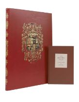
FOLIO SOCIETY, Limited Edition: QUEEN MARY ATLAS. Two Volumes. Folio Society, 2005. Limited Edition No. 581 of 1000. Folio, Bound in full calf le...
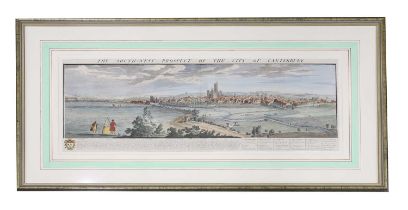
Nathaniel & Samuel Buck:
Nathaniel & Samuel Buck: The South West Prospect of the City of Canterbury. 1738, hand-coloured panoramic view, mounted, framed and glazed. VGpl. ...
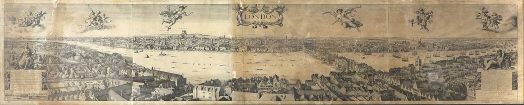
LONDON PANORAMA:
LONDON PANORAMA: Robert Martin after Wenceslas Hollar: Panorama of London, from Bankside. c.1832, Lithograph on four conjoined sheets, [published...
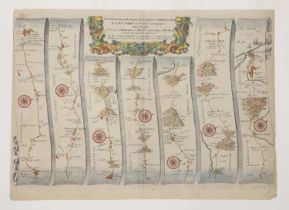
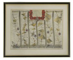
Ogilby, J:
Ogilby, J: The Continuation of the Road from London to Barwick. c.1675, hand-coloured and mounted. 35 x 46cm; The Continuation of the Road from Lo...
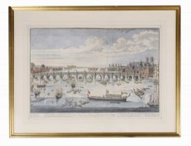
LONDON VIEWS: COLE, Benjamin: The South East prospect of Westminster Bridge. c.1747. Hand-coloured, mounted, framed and glazed; A view of London. ...
The THAMES:
The THAMES: Taunt, H W: A new map of the River Thames from Oxford to London. No date, 5th. Edn. With a photographic frontis, 2 plates, a folding t...
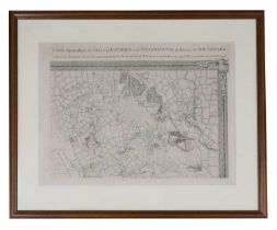
CARTE Topographique des VILLES de LONDRES et de WESTMINSTER, du BOURG de SOUTHWARK, et de Leurs Environs Levè tres exactement sur les lieux par JE...
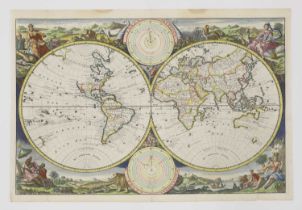
Visscher:
Visscher: Hemisphere world map. Surrounded by landscapes of the world and how they were divided and inhabited by Noah’s descendants. Dutch text to...
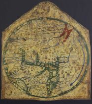
MAPPA MUNDI: The Hereford World Map, The Folio Society, 2010, Limited edition Facsimile of 1000 copies, this being number 502. The map is mounted,...
MAPS: 1- (HOLY LAND.) Wells, Edward, A New Map Shewing the Travels of the Patriarchs...c.1720, hand-coloured, mounted, framed and glazed; 2- A new...
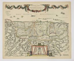
The HOLY LAND: De Wit:
The HOLY LAND: De Wit: Terra Sancta, sive Promissionis olim Palestina recens delineata et in lucem edita per Fredericum De Wit. Amsterdam, c.1670...
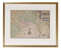
Jan Huygen Van & Hendrik Floris Van Langren: LINSCHOTEN, Deliniantur in hac tabula, Orae Maritimae Abexiae, freti Mecani; al Maris Rubri; Arabia...
SPEED, John:
SPEED, John: Bohemia Newly described by John Speed Anno Dom. 1626. c.1676. Not coloured, 42.5 x 55cm
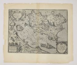
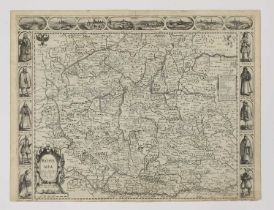
JANSSONIUS:
JANSSONIUS: ITALY: Nova & accurata Tusciae antique descriptio. Autore Ab. Ortelio. (Tuscany). Amsterdam, c.1640. Hand-coloured, 34 x 48cm; Orteliu...
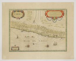
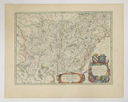
JANSSONIUS:
JANSSONIUS: SOUTH AMERICA: 1- Freti Magellanici ac novi Freti vulgo le Maire exactissima delineatio. Amsterdam, c.1633. Hand-coloured, 37 x 48cm. ...
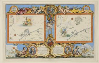
Pine (John):
Pine (John): Two untitled charts showing the progress of the Spanish Armada (nos. 9 & 10), 1739. Two hand-coloured charts on one sheet (as publish...