Refine your search
Sale Section
Estimate
Category
- Books, Manuscripts & Periodicals (202)
- Maps (47)
- Prints & Multiples (22)
- Watercolours (6)
- Arms, Armour & Militaria (3)
- Oil, Acrylic paintings & Mixed Media (3)
- Collectables (2)
- Drawings & Pastels (2)
- Photographs (2)
- Sculpture (2)
- Toys, Models & Dolls (2)
- Chinese Works of Art (1)
- Coins (1)
- Ethnographica & tribal art (1)
- Scientific Instruments (1)
Creator / Brand
- Blaeu (6)
- Ortelius (5)
- J. R. R. Tolkien (3)
- Charles Dickens (2)
- Janssonius (2)
- John Speed (2)
- Rudyard Kipling (2)
- Second World War (2)
- Arnold Floris van Langren (1)
- Arthur Conan Doyle (1)
- Chaucer (1)
- Eric Gill (1)
- Franz Kafka (1)
- Deutsch (1)
- Goya (1)
- Graham Greene (1)
- James Joyce (1)
- James Mcbey (1)
- Laurence Sterne (1)
- Lucas Cranach The Elder (1)
- Marvel (1)
- Mercator (1)
- Myles Birket Foster (1)
- Odhams Press (1)
- Sylvia Plath (1)
- Thomas Hardy (1)
- Tibetan (1)
- Van Keulen (1)
- Virginia Woolf (1)
- William Blake (1)
- William Shakespeare (1)
Item Type
- Book (64)
- Folio (29)
- Map (20)
- Letter (13)
- Famous Author (11)
- Cartographers and Mapmakers (7)
- Poetry (6)
- Manuscript (5)
- 15th-18th Century Art (3)
- Bible (3)
- Etching (3)
- Guide book (3)
- Journal (3)
- 19th-21st Century Art (2)
- Lithograph (2)
- Magazine (2)
- Manual (2)
- Militaria (2)
- Ordnance survey map (2)
- Periodical (2)
- Photograph album (2)
- Portrait (2)
- Road map (2)
- WW2 Militaria (2)
- Advertising (1)
- Anthony Trollope (1)
- Arthur Conan Doyle (1)
- Atlas (1)
- Comic book (1)
- Dictionary (1)
- Drypoint (1)
- Engraving (1)
- Figure (1)
- Landscape (1)
- Modern & Impressionist Art (1)
- Portrait Painting (1)
- Programme (1)
- Programmes (1)
- List
- Grid
A subscription to the Price Guide is required to view results for auctions ten days or older. Click here for more information
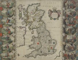

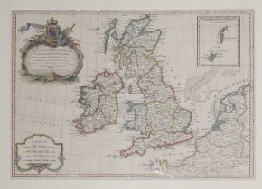
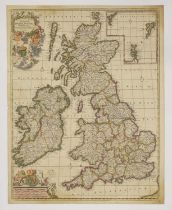
JANVIER, Jean:
JANVIER, Jean: Les Isles Britanniques Comprenant les Royaumes d'Angleterre d'Ecosse et d'Irlande. c.1762, hand-coloured and mounted. 44 x 31cm; Bo...
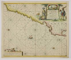
SEA CHART:
SEA CHART: Van Keulen: Paskaart van't Canaal Engelandt Schotlandt en Yrland. c.1708. 58 x 50cm; Bellin: Carte Reduite des Mers du Nord {North Atla...
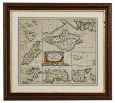
Morden: Robert:
Morden: Robert: The smaller Islands in the British Ocean (The Isle of Wight, Alderney, Guernsey, Jersey, Scilly, Isle of Man, Holy Island and Farn...
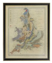
Walker (J & C):
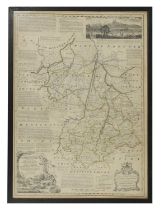
Walker (J & C): A Geological Map of England and Wales. Published by Charles Knight for the SDUK, 1843. Hand-coloured, mounted, framed and glazed ...
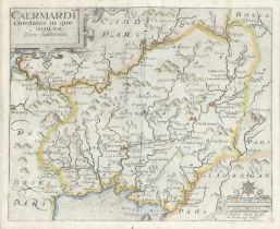
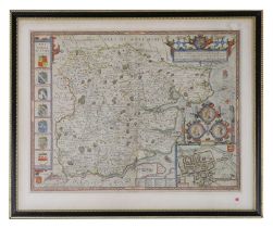
WALES: Blaeu:
WALES: Blaeu: Penbrochia Comitatus et Comitatus Caermaridunum. Amsterdam, c.1662. Hand-coloured, mounted, framed and glazed, 41 x 53cm; Saxton: C...
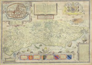
SPEED, John:
SPEED, John: Kent with Her Cities and Earles described and observed, hand-coloured, mounted, framed and glazed front and rear, c.167637 x 49cm Con...
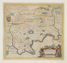
Blaeu, J:
Blaeu, J: Middle-Sexia. Amsterdam, c.1662, Latin text, hand-coloured, 39 x 37cm
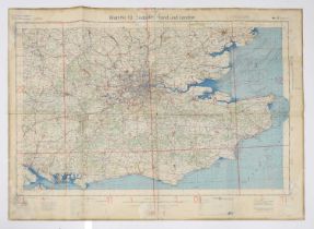
16 Second World War Maps of England, Wales & Scotland, German Luftwaffe. Large folding coloured maps, in German (16)
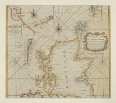
SCOTLAND (2 sheets):
SCOTLAND (2 sheets): CORONELLI, VM: Scotia, parte meridonale; Scotia, parte settentionale, Venice, c.1690. Double-page engraved map of Scotland on...
SCOTLAND (2 Maps):
SCOTLAND (2 Maps): DE WIT, F: Novissima prae caeteris aliis accuratissima Regnorum Angliae, Scotiae, Hiberniae, Amsterdam, c.1690. Hand-coloured e...
SCOTLAND (4 Maps):
SCOTLAND (4 Maps): Collins, Captain Greenvile: The East Coast of Scotland with the Isles of Orkney and Shetland. c.1693, hand-coloured and mounted...
Collection of Maps
Collection of Maps including: Hertfordshire, 1840 and c.1880; Devonshire, c.1748; Cambridgeshire, c.1818; Bedfordshire; Isle of Thanet, c.1850; Bo...
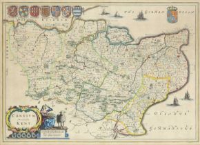
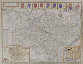
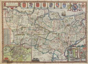
KENT: Jansson, J:
KENT: Jansson, J: Cantium vernacule. Amsterdam, c.1650, hand-coloured, mounted, framed and glazed, 39 x 53cm
GREENWOOD, C & J:
GREENWOOD, C & J: Map of the County of Kent from an actual survey made in the years 1819 & 1820. 1829, hand-coloured, mounted, framed and glazedPl...
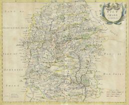
Morden, Robert:
Morden, Robert: Wiltshire. Sold by Abel Swale & John Churchil, c.1722. Hand-coloured, mounted, framed and glazed, 34 x 41cm; Blaeu: (Somerset) Som...
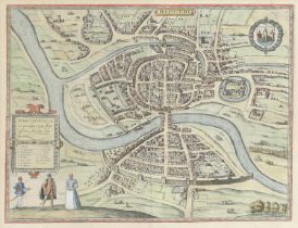
Braun, Georg & Frans Hogenberg: Brighstowe vulgo quondam venta (Bristol City Plan). c.1581 or later, hand-coloured, mounted, framed and glazed, 34...
Speed, John & Norden, John:
Speed, John & Norden, John: Sussex Described and divided into Rapes with the siutuation of Chichester the cheife citie thereof. And the armes of s...
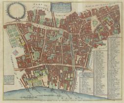
Stow, John:
Stow, John: Farrington Ward without its Division into parishes taken from the last survey. c.1754. Hand-coloured, mounted, framed and glazed, 29 x...
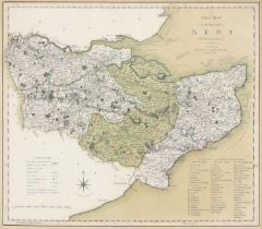
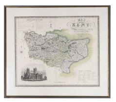
Smith, C:
Smith, C: A New Map of the County of Kent Divided into Lathes &c. c.1804. Hand-coloured, mounted, framed and glazed, 44 x 49cm
![[DRAYTON, Michael]:](https://portal-images.azureedge.net/auctions-2024/sworde1-10059/images/e2010f3e-685e-4235-9c28-b15601140675.jpg?h=210)
[DRAYTON, Michael]:
[DRAYTON, Michael]: KENT. c.1622. Hand-coloured, mounted, framed and glazed, 25 x 32cm
Speed, J:
Speed, J: Kent with her cities and Earles described & observed. Bassett & Chiswell (?), c.1676, hand-coloured, mounted, framed and glazed, 37 x 5...
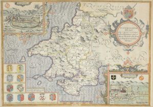
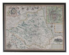
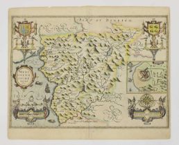
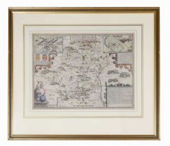
Speed, J:
Speed, J: Penbrokshyre described and the Situations both of Penbroke and St. Davids shewed in due form, c.1676, hand-coloured, mounted, framed an...
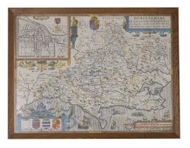
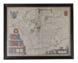
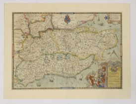
SPEED, John: Dorsetshyre
SPEED, John: Dorsetshyre With the Shyre towne Dorcester described, as also the Armes of such noble families as have bene honored with the Titles t...
SPEED, John:
SPEED, John: Essex, devided into Hundreds, with the most antient and fayre Towne Colchester Described and other memorable Monuments observed. Anno...
SPEED, John:
SPEED, John: The Bishopric and Citie of Durham. c.1612, hand-coloured, mounted, framed and glazed front and rear, 38 x 60cm
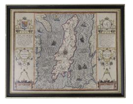
SPEED, John:
SPEED, John: The Isle of Man Exactly described...Described by Tho. Durham Ano. 1595, performed by John Speed Anno 1610. [1676], Bassett & Chiswell...
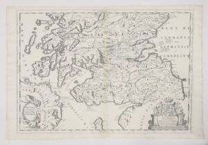
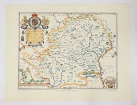
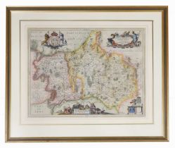
Blaeu, J:
Blaeu, J: Leicestrensis Comitatus. Leicester Shire, Amsterdam, c.1645, (Dutch text to rear). Hand-coloured, mounted, framed and glazed front and r...
Bowen, E:
Bowen, E: An Accurate map of Cambridgeshire divided into its hundreds. c.1760. Mounted, framed and glazed. Glass broken, 52 x 70cm.; Morden, Rober...
WALES (4 Maps):
WALES (4 Maps): SPEED, John: Merionethshire Described 1610. Hand-coloured, 50 x 38cm; Flint shire, c.1610. Hand-coloured, 50 x 38cm; Montgomery Sh...
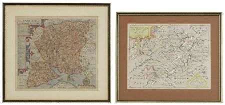
SMITH, C:
SMITH, C: A NEW MAP of the COUNTY of STAFFORD Divided into Hundreds.1804. Hand-coloured 42 x 48cm; A New Map of the County of Berks, divided into ...
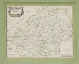
Jansson:
Jansson: Comitatis Cantabrigiensis vernacule Cambridgeshire, Amsterdam, c.1650. Hand-coloured, 51 x 41cm; Middelsexiae, cum Hertfordiae, Comitatu ...
Blaeu, J:
Blaeu, J: Oxonium Comitatus, vulgo Oxfordshire. Amsterdam, c.1662, hand-coloured, 50 x 38cm. Light damp stain to bottom margin; backed on to thick...
SPEED, John:
SPEED, John: SHROPSHYRE DESCRIBED Shropshire. c.1649, hand-coloured. 51 x 38cm: Shrowesbury Described the sittuation of Shrowesbury Shewed, Basset...
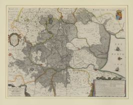
The FENS:
The FENS: Jansson, J: A general Plott and description of the Fennes and surrounded grounds in the sixe counties of Norfolke, Suffolke, Cambridge, ...
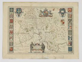
SPEED, J:
SPEED, J: Hartfordshire Described. The sittuations of Hartford and the most ancient towne S Albons with such memorable actions as have happened. J...
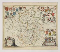
Jansson, J:
Jansson, J: Middelsexiae cum Hertfordiae comitatu (Middlesex & Hertfordshire). Amsterdam, c.1650. Mounted, framed and glazed, 44.5 x 59.5cm
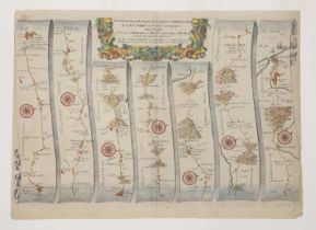
Collection of MAPS,
Collection of MAPS, Hand-coloured, mounted, framed and glazed: Morden: Somersetshire; Ogilby (3 maps): The road from Exeter to Dorchester; From Da...
CHAPMAN, John & Peter ANDRE:
CHAPMAN, John & Peter ANDRE: A Map of the County of Essex from an Actual Survey taken in MDCCLXXII, LXXIII and MDCCLXXIV, Title page dated 1777, ...
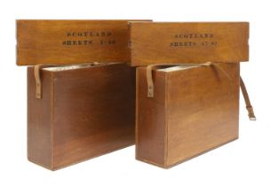
Ordnance Survey of Scotland:
Ordnance Survey of Scotland: Complete set. 92 colour maps, each dissected into 4 sections laid on linen, with numbering tabs, preserved in the pub...
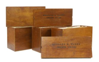
Ordnance Survey of England and Wales: Complete set of the 7th Series. 190 one-inch colour maps, each dissected into 6 sections laid on linen, wit...
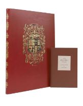
FOLIO SOCIETY, Limited Edition: QUEEN MARY ATLAS. Two Volumes. Folio Society, 2005. Limited Edition No. 581 of 1000. Folio, Bound in full calf le...
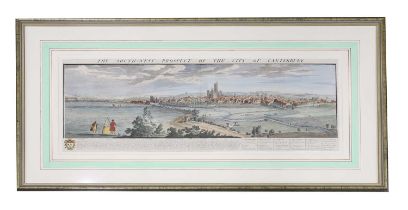
Nathaniel & Samuel Buck:
Nathaniel & Samuel Buck: The South West Prospect of the City of Canterbury. 1738, hand-coloured panoramic view, mounted, framed and glazed. VGpl. ...
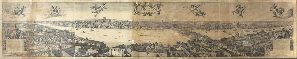
LONDON PANORAMA:
LONDON PANORAMA: Robert Martin after Wenceslas Hollar: Panorama of London, from Bankside. c.1832, Lithograph on four conjoined sheets, [published...
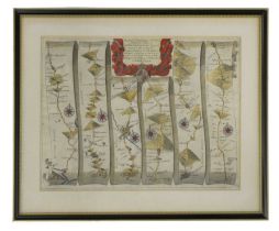
Ogilby, J:
Ogilby, J: The Continuation of the Road from London to Barwick. c.1675, hand-coloured and mounted. 35 x 46cm; The Continuation of the Road from Lo...
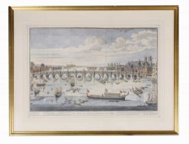
LONDON VIEWS: COLE, Benjamin: The South East prospect of Westminster Bridge. c.1747. Hand-coloured, mounted, framed and glazed; A view of London. ...
The THAMES:
The THAMES: Taunt, H W: A new map of the River Thames from Oxford to London. No date, 5th. Edn. With a photographic frontis, 2 plates, a folding t...
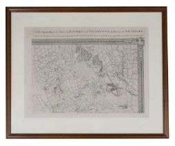
CARTE Topographique des VILLES de LONDRES et de WESTMINSTER, du BOURG de SOUTHWARK, et de Leurs Environs Levè tres exactement sur les lieux par JE...
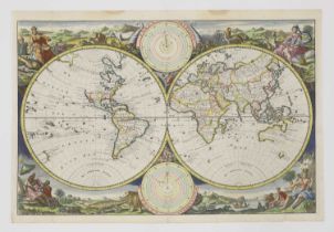
Visscher:
Visscher: Hemisphere world map. Surrounded by landscapes of the world and how they were divided and inhabited by Noah’s descendants. Dutch text to...
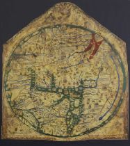
MAPPA MUNDI: The Hereford World Map, The Folio Society, 2010, Limited edition Facsimile of 1000 copies, this being number 502. The map is mounted,...
MAPS: 1- (HOLY LAND.) Wells, Edward, A New Map Shewing the Travels of the Patriarchs...c.1720, hand-coloured, mounted, framed and glazed; 2- A new...
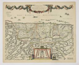
The HOLY LAND: De Wit:
The HOLY LAND: De Wit: Terra Sancta, sive Promissionis olim Palestina recens delineata et in lucem edita per Fredericum De Wit. Amsterdam, c.1670...
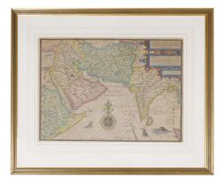
Jan Huygen Van & Hendrik Floris Van Langren: LINSCHOTEN, Deliniantur in hac tabula, Orae Maritimae Abexiae, freti Mecani; al Maris Rubri; Arabia...
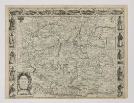
SPEED, John:
SPEED, John: Bohemia Newly described by John Speed Anno Dom. 1626. c.1676. Not coloured, 42.5 x 55cm
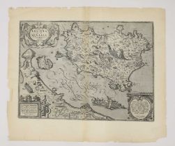
JANSSONIUS:
JANSSONIUS: ITALY: Nova & accurata Tusciae antique descriptio. Autore Ab. Ortelio. (Tuscany). Amsterdam, c.1640. Hand-coloured, 34 x 48cm; Orteliu...
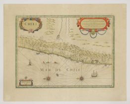
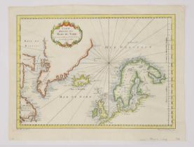
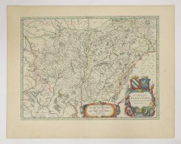
JANSSONIUS:
JANSSONIUS: SOUTH AMERICA: 1- Freti Magellanici ac novi Freti vulgo le Maire exactissima delineatio. Amsterdam, c.1633. Hand-coloured, 37 x 48cm. ...
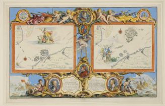
Pine (John):
Pine (John): Two untitled charts showing the progress of the Spanish Armada (nos. 9 & 10), 1739. Two hand-coloured charts on one sheet (as publish...