Madagaskar.: Carte reduite de l'Archipel du Nord-Est de l'Isle Madagascar Kupferkarte von Jean Baptiste Mannevillette, 1775. 53 x 75 cm. Seltene französische Seekarte aus dem 18. Jahrhundert. Sie zeigt das für Frankreich wichtige Gebiet vom nördlichen Madagaskar bis zu zu den Séchelles und entstammt dem berühmten Atlas Neptune Oriental der 1775 in Paris gedruckt wird. - â•”Dabei:â•— A chart of the wester coast of Madagascar. Kupferstich by laurie 1794. Gr.Fol.
We found 32609 price guide item(s) matching your search
There are 32609 lots that match your search criteria. Subscribe now to get instant access to the full price guide service.
Click here to subscribe- List
- Grid
-
32609 item(s)/page
Blathwayt,W.: The Blathwayt Atlas. A collection of 48 manuscript and printed maps of the 17th century relating to the British Overseas Empire in that era... 2 Bde. (Faks. u. Kommentar). Providence, Brown University Press 1970-75. Fol. u. 8°. Lose in Olwd.-Kassette u. Olwd. (Tls. etw. Gebrauchssp.). - Tls. schwach gebräunt.
(Bergen,H.v.: Versuch einer Monographie der China. Nur Atlas. Hbg., Hartwig & Müller 1826). Gr.Fol. Mit 8 kolor. Kupfertafeln. Pbd. d. Zt. mit neuem Lwd.-Rckn. (Stärker best., berieb.). Wellcome II, 147 (inkpl.). Nissen, BBI 144. Pritzel 655. Einzige Ausgabe. - Ohne Textband. Vord. flieg. Vors. mit Ausschnitt, schwach gebräunt, vereinzelt etw. fleckig. Gestempelt.
Meyers: Großes Konversations-Lexikon. Ein Nachschlagewerk des allgemeinen Wissens. 6. neubearb. u. verm. Aufl. Neuer Abdruck. 23 Bde. (inkl. 2 Jahres-Suppl.). Lpz. u. Wien, BI 1908 ff. Gr.8°. Mit zahlr. tls. dplblgr. u. farb. Taf. u. zahlr. dplblgr. farb. Karten. Ohldrbde. - â•”Dabei:â•— Der Neue Brockhaus, Allbuch. 4 Bde. u. Atlas in 5 Bdn. Lpz. 1937 f.
Sammlung: von 11 Schriften Medizin in 12 Bdn. Versch. Formate u. Einbde. â•”Enthält:â•— Sudhoff,K. Kurzes Handbuch der Geschichte der Medizin. Bln., Karger 1922. - Textor,K. Abhandlung über die chirurgischen Krankheiten... Bd. 4. Würzburg, Stahel 1819. - Froriep,R. Atlas Anatomicus. Weimar 1851. Mit 30 Taf. - Auerbach,H.M. Rademachers Heilmittel. 2. Abdruck. Bln., Hirschwald 1852. - Bruno,J.P. Dogmata medicinae generalia... Nbg., Endter 1670. - Proksch,J.K. Die Geschichte der venerischen Krankheiten. 2 Bde. Bonn, Hanstein 1895. - Finger,E. u.a. Handbuch der Geschlechtskrankheiten. Bd. 1. Wien u. Lpz., Holder 1910. - Ancell,H. Vorlesungen über die Physiologie und Pathologie des Blutes... Lpz., Kollmann 1844. - Flexner,A. Medical Education. New York, Macmillan 1925. - Feichtner,C. Die Bekämpfung der Geschlechtskrankheiten. Diessen, Huber 1927. - Galewsky u. Woithe. Die Geschlechtskrankheiten und ihre Bekämpfung. 2. Aufl. Drsdn., Meinhold 1920. - Tls. etw. Gebrauchsspuren.
Mähren.: Topographisch-militairischer Atlas der Markgrafschaft Maehren in 13 Blättern hrsg. von dem Geographischen Institute. Weimar 1809. Grenzkolor. gest. Karte, 12 Karten-Bl. im Format je 28,5 x 38,5 cm u. 1 Karten-Bl. 28,5 x 43,5 cm, jwls. in 4 Segmenten auf Lwd. kasch. u. gefalt. Zus. in Pp.-Schuber d. Zt. (Dieser berieb.).
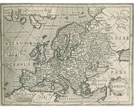
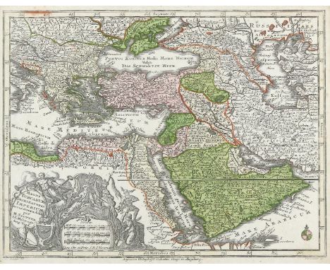
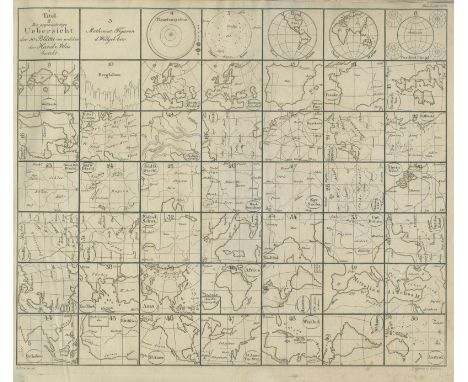
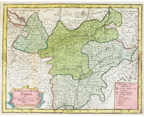
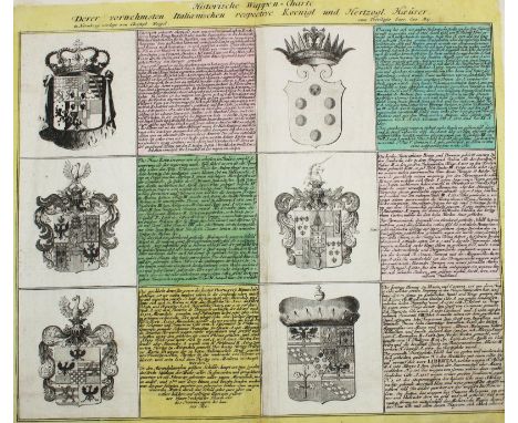
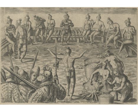
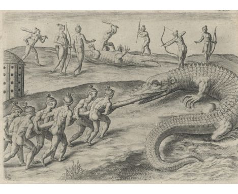
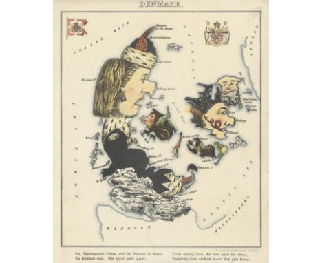
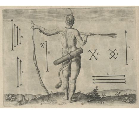
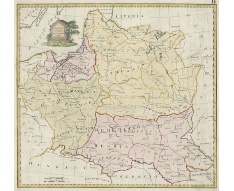
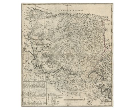
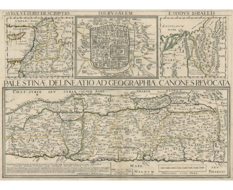
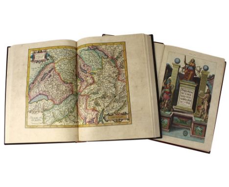
Mercator,G.: Atlas minor, das ist, Eine kurtze, jedoch gründtliche Beschreibung der gantzen Welt... durch Iodocum Hondium mit vielen Kupffern gebessert und vermehrt: und endtlich in unsere hoch Teutsche Sprach versetzt. Amsterdam, I.Hondius für C.Nicolai u. J.Janssonius (1609). Qu.4°. Mit gest. Titel, 1 allegorischen Kupfer sowie 152 Kupferkarten (145 Karten u. 7 Zusatzkarten ohne Rückentext.; davon 28 grenzkolor.). 5 Bl., 676 S., 10 Bl. (d.l.w.). Brauner Ldr. d. Zt. a. 4 Bünden mit Rsch. (Etw. stärker best., berieb., Rckn. etw. wurmspurig, Hdeckel etw. läd.). Koeman 351:21. Phillips 425. - Erste deutsche Ausgabe. Mit der klassischen Kartenfolge: Welt, Erdteile, europäische Gebiete, Afrika (7), Asien (11), Amerika (5), historische Karten der alten Welt/Bibel (6). - Gest. Titel aufgez. u. mit 2 größeren Ausschnitten (Bildverlust), stellenweise gebräunt u. fl., tls. etw. wasserrandig, 1 w.Bl. am Anfang gelockert. - First German edition. With engraved title, 1 allegorical copperplate as well as 152 copperplates (145 maps a. 7 additional maps without text on spine, 28 of them border coloured). 5 pp, 676 pp, 10 pp. Brown leather binding of the time on 4 bands with ribbed boards. (Somewhat more bumped, rubbed, spine somewhat worm-marked, cover somewhat damaged). - Engraved Title opened and with 2 larger cut-outs (loss of image), browned and spotted in places, some waterstains, 1 white sheet loosened at the beginning.
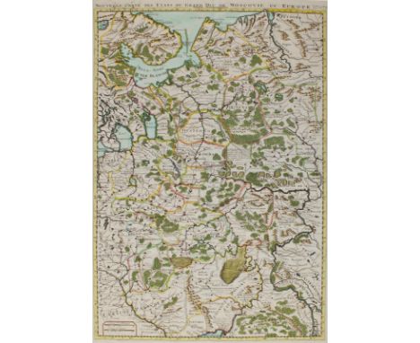
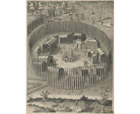
Konvolut: von 7 Schriften in 8 Bdn. Versch. Einbde. â•”Enthält:â•— Berthold,A.A. Lehrbuch der Physiologie des Menschen und der Thiere. 2 Bde. Göttingen 1829. - Ennemoser,J. Der Magnetismus im Verhältnisse zur Natur und Religion. Stgt. u. Tbg., Cotta 1842. EA. - Hartmann,C. Handbuch der Metallgießerei... Textband (ohne Atlas). 2. verm. Aufl. Weimar 1852. - Lorenz,J.F. Erster Cursus der reinen Mathematik... 4. Ausg. Helmstett 1816. Mit 9 Kupfertaf. - Grunert,J.A. Die Kegelschnitte. Lpz. u. Sorau 1824. Mit 7 lithogr. Taf. - Wingate,E. Arithmetick. Containing a plain and familiar method for attaining the knowledge and practice of common arithmetick... 14. ed. London 1720. - Karsten,G. Untersuchungen über das Verhalten der Auflösungen des reinen Kochsalzes in Wasser. SA, Bln. 1846. Mit 2 Kupfertaf. - Tls. etw. Gebrauchsspuren.
Vereinigte Staaten.: Map of the United States of America showing the boundaries of the Union and Confederate geographical divisions and departments, April 9, 1865. Farblithogr. bei Julius Bien & Co., N.Y. (1891-1895). Ca. 42,5 x 70,5 cm. Unter Glas gerahmt (nicht ausgerahmt). Bl. CLXXI aus: Atlas to accompany the official records of the Union and Confederate Armies 1861-1865.
(Barthelemy,J.J.).: Voyage du jeune Anacharsis en Gréce, vers le milieu du quatrième siècle avant l'ère vulgaire (...). Mischaufl. Atlas u. 7 Textbde., zus. 8 Bde. Paris, Didot Jeune (1799) bzw. 1821. Mit 36 (statt wohl 39) tls. mehrf. gefalt. Kupfertafeln. Hldr. (Atlas) bzw. Ldrbde. d. Zt. (Text) (Best. u. berieb., tls. etw. kratzspurig). Vgl. Brunet, I, 674. Chadenat, 4189 und 5890 (Ausgabe von 1790) - Textbde. in vierter Ausgabe dieses berühmten Werkes, welches erstmals 1788 erschien. Der Atlas von 1821. - Stellenweise etw. gebräunt u. fleckig, tls. kl. Randläsuren.
Lallemand,A.: Atlas Topographique du Traite theorique et pratique des operations secondaires de La Guerre. Nur Atlas. Paris, Dumain 1846. Kl.Fol. Mit lithogr. Tit. mit Vign. v. Vernet u. 44 (1 gefalt. u. 1 kolor.) lithogr. Pläne v. G.Engelmann. Hlwd. mit Dsch. (Tls. best. u. berieb.). Mit Umgebungsplänen v. Amberg, Bamberg, Erding, Hanau, Memmingen, Murnau, Nördlingen, Schweinfurt, Weilheim, Weissenburg u.a. - Ohne Textband. Schwach gebräunt, vereinzelt schwach fleckig.
Weltkarte u. Erdteilkarten.: 6 kolor. Kupferstichkarten v. A.Silbereisen bzw. T.C.Lotter aus einem Atlas Minor bei M.Seutter bzw. Tl.C.Lotter, Augsburg um 1780. Je ca. 19,5 x 25,5 cm. Jwls. unter Passep. u. Glas gerahmt (nicht ausgerahmt). Diversi Globi Terr-Aquei, Asia cum omnibus imperiis, Imperium Russiae Magnae, Magni Turcarum... Imperium, Africa, Postarum... Germaniam.
Stieler,A. u. C.G.Reichard.: Hand-Atlas über alle Theile der Erde nach dem neuesten Zustande und über das Weltgebäude. Fragment. Gotha, Perthes 1816 ff. Qu.Fol. Mit 46 meist grenzkolor. Kupferstichkarten. Läd. Kart. d. Zt. Inkl. aller Suppl. ersch. 94 Karten. - Vorhanden: 1 (Titel), 2 (Übersicht), Karten 4-12, 14, 14b, 15, 16 (2x; 1819 u. 1822), 17-22, 22b, 24-26, 29, 32-43, 43b, 45-48, 50. - Gebrauchsspuren, mehrere Karten lose, einige beschn. u. Ränder unterl.
Konvolut.: 7 Werke aus verschied. Bereichen der Naturwissenschaften. 1774-1850. Verschied. Formate. Verschied., tls. läd. Einbände d. Zt. (Außen wie innen mit Gebrauchsspuren). DARUNTER: SIEBOLD, C. Th. E. von, Obseravtiones quaedam de salamandris et tritonibus. Berlin 1828. Mit gefalt. Kupfertafel. - KUTORGA, S., Naturgeschichte der Infusionsthiere. Atlas. Karlsruhe 1841. Mit 7 tls. kolor. lithogr. Tafeln. - DIETRICH, D., Deutschlands kryptogamische Gewächse. Jena 1846. Mit 296 kolor. Kupfertafeln. - MOHL, H., VON, Grundzüge der Anatomie und Physiologie der vegetabilischen Zelle. Braunschweig 1851. - 2 Beilagen.
Sartorius von Waltershausen, Wolfgang,: deutscher Geologe, Professor an der Universität Göttingen (1809-1876). Eh. Brief mit Unterschrift (Kürzel), dat. Göttingen, 3. Juli 1859. 8°. 2 Bl., 3 S. beschrieb. Mehrf. gefalt. An Julius Hey in München, wegen Kupferplatten, die dieser wohl für seinen großen Atlas vom Ätna (1858-61) anfertigen sollte. "...Ich bitte Dich daher die Platten von Cataria nebst Zubehör zurückzuschicken, die Muse und das Geld dir dieselbe zu schicken hätte ich freilich sparen können. Im gleichen bitte ich um Zusendung des Materials und der Zeichnung vom Blatt Ansicht des Val del Bore von oben, welches ich ebenfalls radiren will. Wie viele leere Kupferplatten hast du noch in München?... Die Platte von Aderno hat mir für die Topographie mith gemacht und da ich an derselben gelernt habe, so hoffe ich auch die Platten von Catania glücklich zu vollenden..." - Sartorius (Patenkind Goethes) hatte Hey 1844 eine Kupferstecherlehre bei Francesco Saverio Cavallari vermittelt, 1854 begann er ein Kunststudium an der Akademie in München, wechselte um 1859 allerdings als Privatschüler zur Musik. 1864 lernte er Richard Wagner kennen, der ihn als Gesangstechnischer Beirat nach Bayreuth berief. - Hey war u.a. der Vater des Klass. Philologen Oskar Hey u. des Malers Paul Hey. - Etw. beschäd. duch Öffnen. D
SANTINI, Paolo. Atlas universel dressé sur les meilleures cartes modernes. Venezia, Santini, 17762 vols, Folio, 540 x 395 mm. Engraved title-page to first volume, 2 index plates at the beginning of each volume, 123 maps divided as follows: 60 double-page maps for the first volume, 63 for the second, contemporary watercolor borders, contemporary manuscript title numbering to versos of maps (in very good condition except for the first volume: very small wormhole to inner margin of the first twenty leaves affecting the printing area but not particularly visible, ff. 32-34 and 37 with small waterstain to lower margin; in the second: tear to lower margin of ff. 1, 12 and 13 not affecting engraving). Contemporary interim binding with marbled sides, adorned Venetian paper spine. First edition of the atlas by the brothers Paolo and Francesco Santini, considered one of the most important universal atlases printed in Italy in the 18th century. The editors substantially reproduced, retaining toponyms and inscriptions in French, the Atlas Universel published in Paris in 1757 by Gilles and Didier Robert de Vaugondy, but made several changes especially to the maps of the Italian regions. The plates, signed by Paolo Santini and his brother Francesco, are based on the works of the best geographers of the time: d'Anville, Bellin, Bonne, Boscovich, Clarici, De L'Isle, Homan, Jaillot, Janvier, de Vaugondy and Rizzi Zannoni.Tooley, p. 541 e 559; NMM III, 277; Nordenskiold 276; Phillips Atlases 657; Gallo, R. Pp. 153-214.
Matchbox Superfast & Later Models, including MB-74E Fiat Abarth, MB-52C BMW M1, MB-16C Pontiac Firebird, MB-67C Datsun 260-Z, MB-14C Leyland Petrol Tanker, MB-45B BMW 3.0 CSL, MB-49C Crane Truck, MB-17B Londoner, MB-23B Atlas Truck, MB-73C Ford Model A, with twenty six later window box issues, G-E, boxes P-G, majority of window box issues opened and taped shut (36)
Atlas Editions - EFE - Lledo - Others - A mixed group of boxed and unboxed diecast models vehicles in various scales, and a plastic fork lift truck kit. Lot includes EFE #20626 Plaxton Premier Dart 'Midland Red'; Atlas Editions #4642102 Burlingham Seagull 'J.Whittle'; Eagle Coach 'Hank Williams'; Kibri #10564 HO Fork Lift and similar . One of the boxed models sits loose within its box, otherwise conditions appear Mint, housed in Fair - Good boxes. Boxed kit appears Good with loose parts and instruction in Good box. Unboxed models show some dusty display signs and appear to range Fair Plus - Very Good and some would benefit from cleaning. All items are unchecked for completeness. (This does not constitute a guarantee) (K)
This captivating engraving by Theodor de Bry vividly portrays a ceremonial moment where the king receives the queen amidst an elaborate display of dancing and rituals. The scene is rich in cultural detail, highlighting indigenous traditions. This print offers an invaluable glimpse into the ceremonial practices of the depicted culture, making it a vital historical record from the Age of Discovery. Condition Report: Minor tear to the left margin. Signs of wear. Image Size: 32.5 x 23.5 cm (12.8 x 9.3 inches). Keywords: Theodor de Bry, Grands Voyages, indigenous rituals, ceremonial dance, king and queen, historical engraving, Age of Exploration, cultural traditions, early encounters, 16th-century prints, exploration history, indigenous royalty, colonial records, ethnographic art, travel books, atlas, theatrum, terrarum
View of Havana Harbour, engraved by Heyden from a painting by Joseph Vernet. Size: 18 x 23 cm. Condition: a good example. Published: Paris, c. 1780. Keywords: cuba, south america, america, west indies, atlas, town plan, city view, engraving, etching, copper plate, antique map, antique view, harbour, sea view
A close copy of John Thornton's chart of Barbados, first published c.1700, from the Irish pirate edition of Mount & Page's 'The English Pilot. The Fourth Book Describing The West India Navigation...', the first sea atlas of America containing charts only from English sources. Greierson (1680?-1753) may have been Printer to the King in Ireland, but this did not stop him pirating atlases including those of Thornton and Moll. Size: 29 x 26cm. Condition: a good example. Published: Dublin: George Grierson, 1749, set in text. Keywords: America, South America, Cuba, Barbados, West Indies, Gulf of Mexico, Atlas, Antique map, Nautical chart, city plan, town plan
This intriguing engraving by Theodor de Bry captures a Native American council meeting in Florida, vividly illustrating their decision-making process. At the centre, a man with arms outstretched presides over the gathering, while others sit on a bench, passing a shell from which they drink. In the foreground, three women prepare a liquid mixture by boiling and stirring, adding an essential dimension to the scene. On the left, European settlers equipped with guns and spears converse, observing the proceedings from a distance. De Bry's engravings, based on original accounts and illustrations, were instrumental in shaping European perceptions of indigenous peoples during the Age of Discovery. Engraver: Theodor de Bry Published in: Brevis Narratio eorum quae in Florida Americae provincia Gallis acciderunt (Great Voyages, Part II), 1591 Condition Report: Signs of wear. Image Size: 34 x 24 cm (13 3/8 x 9 1/2 inches) Keywords: Native American council, Theodor de Bry, Florida, Great Voyages, indigenous rituals, colonial encounters, early American history, Age of Discovery, cultural anthropology, historical engraving, 16th-century illustration, Brevis Narratio, European exploration, ethnographic depiction, Native American customs, De Bry engravings, travel book, Atlas, Historical account, New world,
This powerful and captivating engraving by Theodor de Bry portrays the Timucuan Indians of Florida defending their village against an onslaught of crocodiles. The image offers a dramatic depiction of the challenges faced by the Timucuan people as they protect their homes and families from the dangers of their environment. De Bry’s engravings, derived from original illustrations, played an essential role in documenting the early encounters between European explorers and indigenous peoples, offering a unique lens into these historical moments. Engraver: Theodor de Bry Published in: Brevis Narratio eorum quae in Florida Americae provincia Gallis acciderunt (Great Voyages, Part II), 1591 Condition Report: Signs of wear. Right margin trimmed. Image Size: 33.5 x 23.5 cm (13 1/4 x 9 1/4 inches) Keywords: Timucuan Indians, crocodile defence, Theodor de Bry, Florida, Great Voyages, indigenous struggle, natural dangers, early American history, ethnographic depiction, historical engraving, 16th-century illustration, Brevis Narratio, Native American resilience, De Bry engravings, European exploration, indigenous encounters, travel book, Travel atlas, travel engraving, exploration, atlas, New world, Florida, America
A charming anthropomorphic map of Denmark, drawn by Lilian Lancaster Tennant (1852–1939) for Geographical Fun, a whimsical atlas of caricature maps of European countries. The map features Denmark as a skating figure, accompanied by a poetic verse referencing Shakespeare's Prince and the Princess of Wales. Published in London by Hodder & Stoughton, 1869. Condition Report: Minor wear to left margin with small hole. Image Size: 25 x 21 cm (9.8 x 8.3 inches) Keywords: Anthropomorphic map, Denmark caricature, Lilian Lancaster Tennant, Geographical Fun, William Harvey, 19th-century pictorial maps, Hodder & Stoughton, European caricature maps, whimsical cartography, Denmark 1869, political map, pictorial map, curiosity.
This fine engraving by Theodor de Bry presents a Native American man standing with a bow and arrow, holding a bundle of arrows. The print features distinctive markings that are associated with the chief men of Virginia, each marking representing the individual’s identity or tribal affiliation. The image is part of De Bry's larger collection documenting the early encounters between European explorers and Native Americans in the Americas. Engraver: Theodor de Bry Published in: Brevis Narratio eorum quae in Florida Americae provincia Gallis acciderunt (Great Voyages, Part II), 1590 Condition Report: Signs of wear consistent with age, manuscript writing at the top of the sheet. Image Size: 31.5 x 24 cm (12.4 x 9.45 inches.) Keywords: Virginia, Native American marks, bow and arrow, Theodor de Bry, Great Voyages, 16th-century engraving, indigenous symbols, Native American chiefs, early American history, cultural documentation, historical engraving, Brevis Narratio, ethnographic illustration, European exploration, travel book, travel atlas, New world, American exploration, Virginia, Virginia map, Travel account, 16th century travel, atlas
Rare map of the former Kingdom of Poland and Lithuania, engraved by Samuel John Neele and published in London in 1790 as part of Thomas Stackhouse's An Universal Atlas. This copper engraving presents detailed cartographic features, enhanced by contemporary hand colouring. The map reflects the geopolitical landscape of the late 18th century. Condition Report: Good condition. Contemporary colouring with paper featuring watermarks. Image Size: 38 x 41.5 cm (15 x 16.3 inches). Keywords: Poland map, Prussia map, Lithuania map, Samuel John Neele, Universal Atlas, 18th-century maps, copper engraving, antique maps, historical cartography, Stackhouse atlas
This detailed map of the Bannat of Temeschwar, published by the Briffout Library in Vienna in 1738, offers a snapshot of the region during the early 18th century, following the establishment of the Habsburg administration in the area after the Austro-Ottoman War (171 6- 1718). The map shows towns, cities, and transportation routes, with significant emphasis on Belgrade, a crucial strategic city within the region. The map is notable for depicting the area divided into districts, as organized by the renowned military leader and statesman, Prince Eugene of Savoy. Prince Eugene's military campaigns had solidified Habsburg control over the region, and this administrative division reflects his vision for stabilizing the territory. The map also highlights the location of copper and silver mines, vital economic assets that contributed to the wealth and power of the Habsburg Monarchy. Condition: scratches to surface Size: 53.5 x 48 cm Published: Vienna, Briffout Library 1738 Keywords: Europe map, Romania map, Ukraine map, Balkans, Eastern europe, town plan, city plan, city view, town view, atlas map
The third edition of this attractive and elaborate folding map of England and Wales denoting the complex geology of both countries in fine original colour. With an extensive key giving details of the use and meaning of colour on the map, in the top right hand corner. The railways are shown, and there are six illustrative geological sections in the margin. Size: 99 x 86 cm. Condition: Staining, Some minor tears to the fold lines. Dissected and backed on linen. Published: London: Stanford, 1872. Original colour. Keywords: London, United Kingdom, England, Wales, Geology, travel, geography, rock, oil, minerals, atlas, book, science book
This historic engraving, The Towne of Pomeiooc, is one of the most celebrated depictions of early Native American life in the New World. Created by Theodor de Bry in 1590 after John White’s 1585 watercolour Indian Village of Pomeiooc, it was first published in de Bry’s Latin edition of Thomas Harriot’s A Briefe and True Report of the New Found Land of Virginia. The engraving provides a detailed view of a Native American settlement located between Wyesocking Bay and Lake Landing, North Carolina, as designated on de Bry’s map Americae Pars Nunc Virginia Dicta. John White’s map La Virginea Pars places Pomeiooc closer to modern-day Lake Mattamuskeet. Annotated by Harriot and engraved by de Bry, this print combines ethnographic accuracy with artistic beauty, showcasing the architecture, daily life, and culture of the indigenous inhabitants. Condition Report: Trimmed right margin. Signs of wear. Image Size: 33.5 x 24.5 cm (13.2 x 9.6 inches). Keywords: Theodor de Bry, John White, Pomeiooc, Native American village, early Virginia, Thomas Harriot, Richard Hakluyt, 16th-century engraving, New World exploration, indigenous settlement, historical cartography, colonial America, ethnographic art, Lake Mattamuskeet, Wyesocking Bay, Harriot's Report, La Virginea Pars, Virginia, north Carolina map, travel book, atlas.
A rare and detailed map of the Holy Land and its surroundings, featuring multiple small maps that illustrate key biblical locations and events. The lower part depicts Palestine, oriented to the east and divided according to the Twelve Tribes of Israel, running from Sidon to Rhinocolura along the coastline. The upper part contains three maps: one showing ancient Syria ("Syriae veteris descriptio"), a plan of ancient Jerusalem ("Hierusalem"), and a map of the Exodus of the Israelites from Egypt through the Red Sea and Sinai Peninsula until they reached Palestine ("Exodus Israelis"). This map was originally published as part of the historical atlas Parellela geographie veteris et novae by the Jesuit Priest Philippe Briet. Published Paris, 1641 Philippe Briet. Condition: Small signs of wear Size: 39.5 x 54 cm (15.6 x 21.3 inches). Keywords:Philippe de La Rue map, Holy Land map, ancient Jerusalem, Exodus map, biblical cartography, 17th-century maps, historical atlases, Philippe Briet, Paris maps, rare antique maps.
Heritage and Atlas group 1/43 F1 Formula 1 Racing Cars to include Jordan 194 Sasol Eddie Irvine, Tyrrell Yamaha 023 Mika Salo, Tyrrell Yamaha 022 Mark Blundell, McLaren Honda MP4/5B 1990 Ayrton Senna plus others as shown. All appear without fault in good original perspex display cases some with outer sleeve. (12)
2 Faksimile zum Mercator-Atlas u. den "Civitates Orbis Terrarum", Faksimile des Mercator-Atlas v. 1595, braun-roter geprägter Ledereinb., Teilvergoldung, 45 x 33,5 cm, Auswahlfaksimile aus Georg Brauns und Franz Hogenbergs "Civitates Orbis Terrarum. Beschreibung und Contrafactur der vornembster Stät der Welt", basierend auf der 6-bänd. Reprintausgabe Stuttgart, Verlag Müller und Schindler, 1574-1618, roter Ganzledereinb. mit reicher Vergoldung und Ganzgoldschnitt, 42,5 x 30 cm, jeweils erschienen Coron bei Kindler Verlag Berlin 2004, sehr guter Zustand, 4843 - 0011
Russia.- Le Clerc (Nicolas Gabriel) [Histoire physique, morale, civile et politique de la Russie], Atlas vol. only, 38 engraved plates and maps, many folding, 16 letterpress tables, some folding, lacking general map of Russia, a few minor tears and occasional foxing, contemporary calf-backed boards, rebacked preserving old spine, corners renewed, folio, Paris, [1783-94].*** Includes a fine plan of St. Petersburg by Tardieu after Dubuisson and several views of the banks of the Neva.
Justus Juncker (German, 1703-1767) Tavern Interior 18th century Oil on copper, in pristine condition This work was reproduced in a print by Charles Spooner, published by John Bowles (British Museum no. 2010,7081.3273), c. 1753/63. This subject was also engraved, with slight alterations, by William Ward, as being after Morland, published by William Holland in 1788 (Frankau 272). There is also another version in the same direction by Purcell, published by Sayer (2010,7081.3274). The Lennox-Boyd database suggests that the racing print on the wall is probably taken from Richard Houston's 'Careless beating Atlas'. Dimensions: (Frame) 13 in. (H) x 18 in. (W) (Copper) 10 in. (H) x 15.25 in. (W)
A collection of assorted boxed diecast vehicles including Atlas Editions Great British Buses, The Greatest Show On Earth and Grand Prix Legends Of Formula 1, Shell Classic Sports Car Collection, Corgi Special Edition Somerfield lorry and van, Lledo Thrust SSC Super Sonic Car, Days Gone etc. Together with a Scalextric C053 Datsun 260Z slot racing car (approx. 50)

-
32609 item(s)/page