We found 36463 price guide item(s) matching your search
There are 36463 lots that match your search criteria. Subscribe now to get instant access to the full price guide service.
Click here to subscribe- List
- Grid
-
36463 item(s)/page

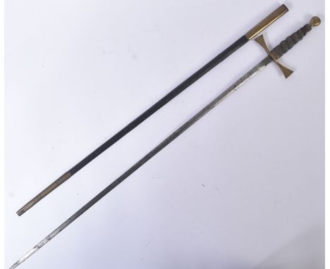
Lot 412
A 19th Century Victorian gentleman's Masonic short sword. The sword having a round brass pommel, wooden shagreen covered grip and splayed brass cross guard. Makers mark for London makers J.J Caney to the ricasso and the blade etched with floral motifs and the masonic square and compass. Measures approx 88cm.

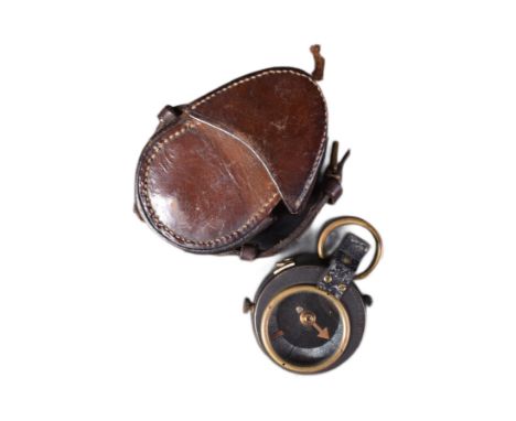

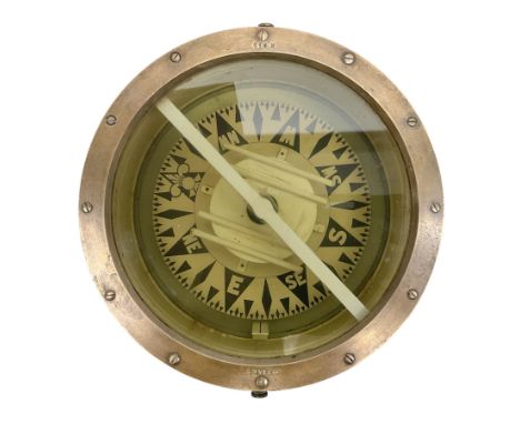
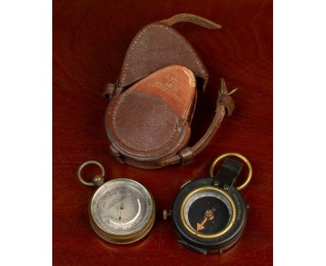
Lot 502
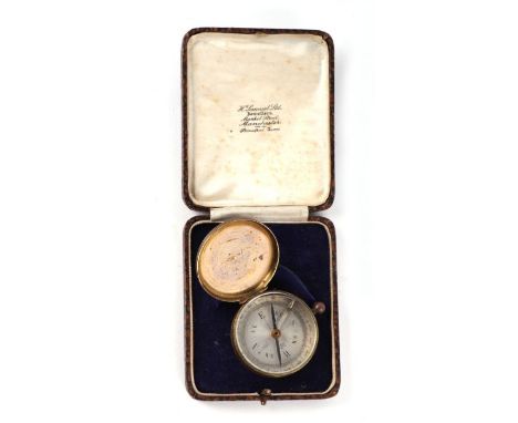
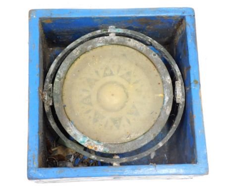
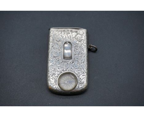
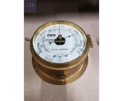
A Late 19th Century Brass Abney Level, Short & Mason Limited London Level, in black enamelled brass, with a compass and spirit level attached to a protractor set on a square sighting tube, 2 Military Issue 6" Trough Compasses, one in a mahogany case with sliding cover, and stamped with broad arrows, one in a metal case
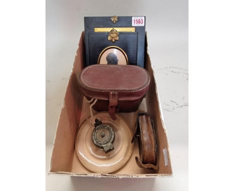
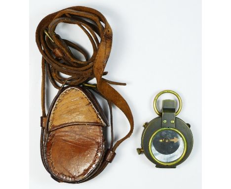
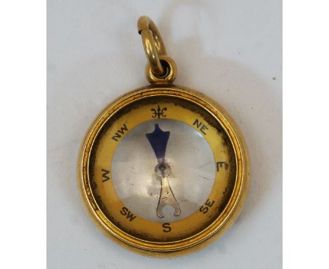
Lot 1563
A mixed lot, comprising: a pair of 19th century portrait miniature silhouettes of 'Captain Edward Inge, 4th Lt Dragoons' and 'Rev J R Inge,...Vicarage, Scarboro', Yorkshire', each with gilt highlights, 8.5 x 6.5cm oval; together with an early 19th century portrait miniature on ivory of a lady with a harp, 9.8 x 7.7cm; a World War I period pocket cased leather compass; and two others. (6) DEFRA Ivory Act submission refs: 1FPAVAG1

Lot 100
Forty Three Sony Playstaion 2 games, cased, to include Maximo Army Of Zin, I-Ninja, Alien Hominid, Peter Jackson's King Kong, Star Wars Starfighter, Piglet's Big Game, Heavenly Sword, Gran Turismo 5 Prologue, Ben 10 Cosmic Destruction, Assassin’s Creed Revelations, Mercenaries 2 World In Flames, Duke Nukem Forever, Toy Story 3, Ratchet & Clank A Crack In Time, White Knight Chronicles II, Avatar The Game, Ghostbusters The Video Game, Spec Ops The Line, FIFA 11, Saints Row 2, WET, FIFA Street, Command & Conquer Red Alert 3 Ultimate Edition, Fracture, Viking Battle For Asgard, Of Orcs And Men, Resistance Fall Of Man, Disney Pixar Ratatouille, Killzone 3, Uncharted 3 Drake’s Deception, FIFA 08, Call OF Juarez Bound In Blood, FIFA 10, Clive Barker’s Jericho, FIFA 12, The Golden Compass, Darksiders, Ratchet & Clank Tools Of Destruction, Risen 2 Dark Waters, Conan, Golden Axe Beast Rider, Disney Bolt and Syndicate, together with seven Playstation 2 games, cased, to include Spider-Man 3, Lego Star Wars II The Original Trilogy, WWE Smackdown Vs Raw 2008, Final Fantasy X, The Incredibles, Final Fantasy XII and Ratchet & Clank Locked And Loaded, also including a DJ Hero Controller
Lot 72
Collector's Items, consisting of: chess/backgammon board, chess pieces, scales, military compass, pocket compass, linen, 1930's dress, ''The Housekeepers instructor'' book, etcChess Set - There are 32 pieces present. The white knight is broken and repaired. The black bishop is chipped. Another black bishop with matching face, but the top is uncarved.
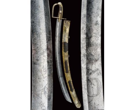
Lot 134
dating: 18th Century provenance: Hungary, Wide, curved, single-and-false-edged blade with wide fuller at the center. The first part engraved on the right side with numbers and cabalistic symbols between star and crescent moon while the left side is decorated with compass rose, stars, sun and crescent moon. Brass, one-quillon hilt with sheath-guard wings, quillon and loop-guard with grooves, the loop-guard with pierced and wavy back. Long cap with groove in the upper part, leather-covered wooden grip (small missing parts) without wire binding, with rivet at the center with flower and fretwork under the pommel. Leather-covered wooden scabbard with brass mounts with remains of silver plating, decorated with grooves and floral motifs at the cap and at the chape. Two suspension rings. length 92.5 cm.
Lot 4
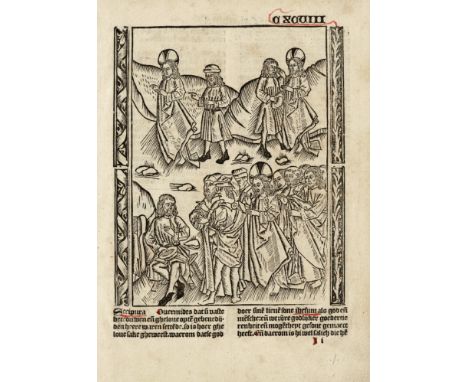
Master of Delft - Judgement of Christ, Judas hanged / Description: Full page incunabula woodcut from Ludolphus de Saxonia, "Dit es dleué our love, lords ihesu christi". Anonymous Dutch translation. Published by Henrick Eckert van Homberch in Antwerp in 1503. Botke, K. These 113 woodcuts, which have mostly been used in early Dutch books, are attributed to the second Master of Delft, the Master of the Delbecq-Schreiber passion and the Master of the Virgo inter Virgines. This woodcut was already used in earlier editions before 1500. / Dimensions: 19,00 x 15,00 cm / Condition: Excellent condition. / Literature: Conway (1884) and in "The guilder compass" (1951). Botke, K. --- Prof. Henri Defoer, history of the woodcuts from the Ludolphus editions. ( Jaarboek voor Nederlandse boekgeschiedenis 24/2017) / Medium: woodcut /Circa: 1480-1503
Lot 49
NO RESERVE Richardson (A.E.) Monumental Classic Architecture in Great Britain and Ireland during the Eighteenth & Nineteenth Centuries, [c.1914] § Stevenson (J.J.) House Architecture, 2 vol., 1880 § Shute (John) The First & Chief Groundes of Architecture...first printed in 1563, out-of-series copy from a limited facsimile reprint, original cloth-backed boards, spine a little frayed, 1912 § Architectural Publication Society. The Dictionary of Architecture, 8 vol. [&] Detached Essays and Illustrations, together 9 vol., most later buckram, rebacked, rubbed, n.d. § Summerson (John) The Unromantic Castle and Other Essays, 1990 § Gerbino (A.) & Stephen Johnston. Compass and Rule: Architecture as Mathematical Practice in England 1500-1750, New Haven and London, 2009 § Curl (James Stevens) The Art and Architecture of Freemasonry, 1991 § Richardson (Harriet, editor) English Hospitals, 1660-1948: A Survey of Their Architecture and Design, 1998, illustrations, all but the third & fourth original cloth, the first two pictorial gilt, rubbed, the last four with dust-jackets; and a quantity of others on architecture, v.s. (c.100)

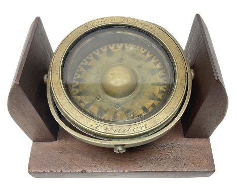
Lot 647
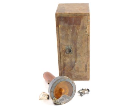
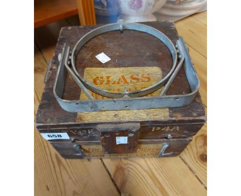
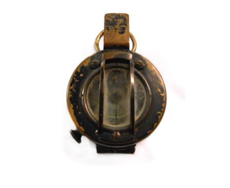
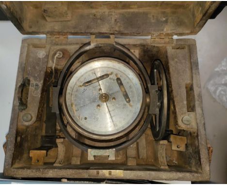
A brass miner's dial or surveyor's compass, the silvered dial inscribed Bradford London, dial 12 cm diameter, cased and a cased Surveyor's level by Chadburn Brothers Sheffield (2)Miner's dial - Some minor wear to the silvered dial, cross hairs broken, single spirit level. case lacking fittings.Surveyor's level - general wear and rubbing to the finish. Spirit level glass cracked, some verdigris around the spirit level casing. Fitted case with adjustable tripod mount, label for J. Halden & Co Ltd.
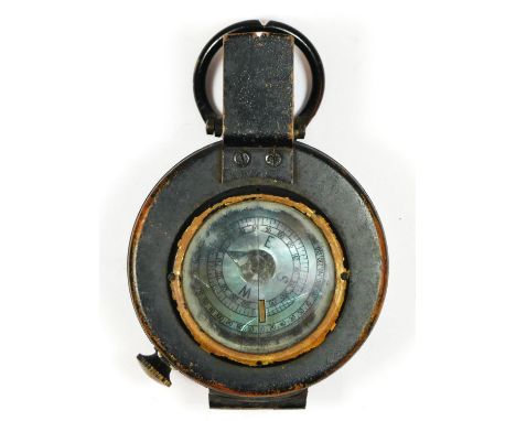
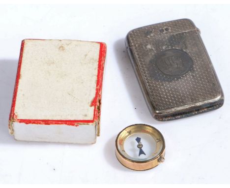
Lot 105
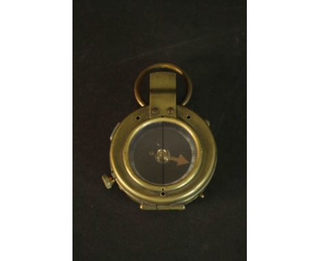
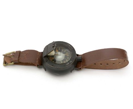
A WWI military Verners Pattern compass with leather case, together with a Victorian pocket barometer and thermometer, the silvered dial signed 'S E Will, Maker to the Royal Navy, Liverpool, Glasgow & London', the compass 5.5cm diameter and the case stamped 'D. Stocks 1918 Edinburgh', the barometer 4.8cm diameter (2)The compass with minor marks but in generally good condition considering age, the barometer with silvered back plate, oxidation to the dial, wear to the lacquer overall but especially the suspention loop, minor marks and scratches due to use.
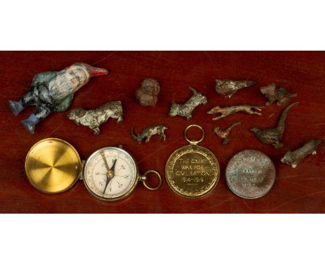
Lot 28
A small group of Austrian cold-painted animals and a Great War Medal awarded to Mid. R. E. S. Hughonin, R.N., the cold-painted animals consisting of six dogs, three pheasants, an antelope, also with a lead gnome, a compass and a 1935 jubilee buttonThe painted items with chips, marks and losses overall, the antelope with loss to one leg, the button dented, the compass with some oxidation, the medal with some minor dents and no ribbon.

Lot 146
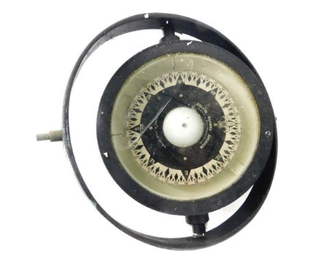
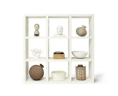
An installation of nine works of art and sculpture including a plaster head and clenched fist by Sir Eduardo Paolozzi (British, 1924-2005) housed within white painted display shelvesThe shelves made by Benchmark FurnitureAlso within the collection is a ship's compass within an oak case, two Indian cooking vessels, a polychrome decorated head of a girl and a footbath, all collected by Sir Terence, the set of open shelves: 200.5cm wide, 40cm deep, 200.5cm high (78 1/2in wide, 15 1/2in deep, 78 1/2in high) the plaster head by Sir Eduardo Paolozzi: 31.5cm high (10)Footnotes:For a maquette of the Benchmark shelves please see Lot 185.This lot is subject to the following lot symbols: AR TPAR Goods subject to Artists Resale Right Additional Premium.TP Lot will be moved to an offsite storage location (Cadogan Tate, Auction House Services, 241 Acton Lane, London NW10 7NP, UK) and will only be available for collection from this location at the date stated in the catalogue. Please note transfer and storage charges will apply to any lots not collected after 14 calendar days from the auction date.For further information on this lot please visit Bonhams.com
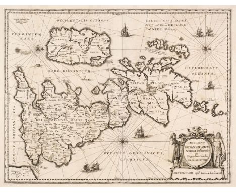
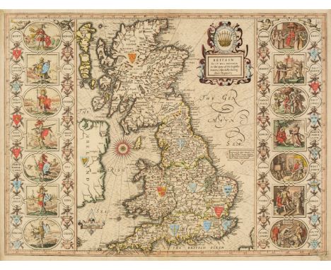
Lot 115
British Isles. Jansson (Jan & Ortelius Abraham), Insularum Britannicarum Acurata Delineatio ex Geographicis Conatibus Abrahami Ortelii, Amsterdam, 1646 [or later], an uncoloured historical map engraved by Pieter van den Keere, large decorative cartouche, compass rose and numerous rhumb lines, orientated to the west, several repaired marginal closed tears, the whole backed with archival tissue, 395 x 510 mm, French text on verso, together with another copy similar, plus Mercator (Gerard). Tab. I. Europae Continens Albion Britanniam et Hiberniam, circa 1690, uncoloured engraved Ptolemaic map of the British Isles with Scotland orientated to the east, slight marginal staining, one vertical crease, 340 x 410 mm, with Pigot (James). Pigot & Co.'s New Map of England & Wales with part of Scotland..., circa 1840, engraved map with contemporary outline colouring, some offsetting, old folds, 705 x 535 mm, QTY: (4)
Lot 119
* British Isles. Speed (John), Britain as it was devided in the tyme of the English Saxons especially during their Heptarchy, Thomas Bassett & Richard Chiswell [1676], hand coloured engraved map, large strapwork cartouche, compass rose and numerous rhumb lines, the vertical borders decorated with historical scenes, slight creasing, occasional worm holes affecting the printed surface, 385 x 510 mm, framed and double-glazed, English text on versoQTY: (1)
![* Cornwall. Speed (John & Norden John), Cornwall, Thomas Bassett & Richard Chiswell [1676], uncoloured engraved map,](https://cdn.globalauctionplatform.com/f2d55b0d-bea0-4ba1-96c5-af5f00b8a264/82db9b1f-15e2-4f10-a51f-af5f011dc4b8/468x382.jpg)
Lot 131
* Cornwall. Speed (John & Norden John), Cornwall, Thomas Bassett & Richard Chiswell [1676], uncoloured engraved map, inset view of Launceston, large strapwork cartouche and compass rose, very slight staining and dust soiling, some toning to the central fold, 385 x 510 mm, framed and double-glazed, English text on versoQTY: (1)
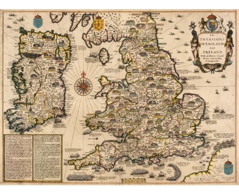
Lot 138
* England, Wales & Ireland. Speed (John), The Invasions of England and Ireland with al their Civill Wars since the Conquest, George Humble, circa 1627, hand-coloured map, engraved by Cornelius Danckerts, large compass rose and numerous rhumb lines, good margins, 380 x 515 mm, framed and double-glazed, English text on versoQTY: (1)
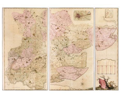
Lot 139
Essex. Chapman (John, and André, Peter). A Map of the County of Essex from an actual survey taken in MDCCLXXII: LXXIII & MDCCLXXIV by John Chapman and Peter André, 2nd edition, W. Keymer, Colchester, 1785, large scale engraved map sectionalised and laid on linen, bright contemporary hand colouring, large decorative cartouche, inset list of subscribers, inset plan of Harwich Harbour and map of Colchester and compass rose, together with the index key map on a separate sheet, all edged in blue silk, western sheet 2260 x 1170 mm, central sheet 2260 x 1190 mm, eastern sheet 2260 x 600 mm, index map 450 x 590 mm, slight offsetting, contained in a 19th-century cloth slipcase with old auction label to the upper cover, slipcase worn and rubbedQTY: (1)NOTE:Chapman and André's meticulously detailed and accurate survey of Essex resulted in the finest large-scale map of the county. It was the first to depict minor roads and included every country house and cottage, milestone, bridge, turnpike, creek, ferry, cliff and even a duck decoy. It is unlikely that more than 300 copies of the first edition were sold and the second edition, issued in 1785, sold even less. A little-known 3rd edition (not held by the British Library) was published in Chelmsford in 1833.
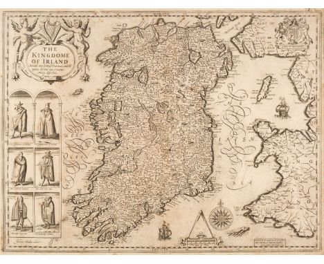
Lot 155
Ireland. Speed (John), The Kingdome of Ireland Devided into severall Provinces and then again divided into Counties newly described, William Humble, 1651, uncoloured engraved map, decorative cartouche, compass rose and six inset costumed figures, slight staining and creasing, occasional very small holes affecting the printed image, two margins strengthened on verso, slight creasing, 385 x 505 mm, no text on versoQTY: (1)

Lot 171
* Merionethshire. Speed (John), Merionethshire, Described, George Humble, circa 1627, hand-coloured engraved map, large strapwork cartouche, mileage scale and compass rose, very slight text show through, 3680 x 505 mm, mounted, framed and glazed, together with Saxton (Christopher & Hole G.). Cestriae Comitatus Romans Legionibus et Coloniss olim insignia vera et absolute descriptio, circa 1610, hand-coloured engraved map, large strapwork cartouche, slight creasing, 260 x 310 mm, framed and glazed, with Saxton (Christopher & Kip W.). Denbigh Comitatus pars olim Ordovicum, circa 1610, hand-coloured engraved map, large strapwork cartouche and mileage scale, 260 x 315 mm, mounted, framed and glazedQTY: (3)
![North Wales. Speed (John), Montgomery, Flint & Denbighshire..., [1611 - 27], three county maps, including Montgomery Shir](https://cdn.globalauctionplatform.com/f2d55b0d-bea0-4ba1-96c5-af5f00b8a264/99f5e414-f0f9-4c17-b2e3-af5f011de9ef/468x382.jpg)
Lot 177
North Wales. Speed (John), Montgomery, Flint & Denbighshire..., [1611 - 27], three county maps, including Montgomery Shire, 1st edition, John Sudbury & George Humble [1611], hand-coloured engraved map, inset town plan of Montgomery, large strapwork cartouche, mileages scale and compass rose, some marginal fraying, vertical margins extended, central fold strengthened on verso, 385 x 510 mm, English text on verso, together with Denbigh Shire, John Sudbury & George Humble, circa 1627, hand coloured engraved map, inset town plan of Denbigh, slight creasing, central fold and lower margin strengthened on verso, 380 x 510 mm, English text on verso, with Flint-Shire, John Sudbury & George Humble, circa 1627, hand coloured engraved map, inset town plans of Flint and St Asaph and a vignette view of St Winifred's Well, slight staining, occasional repaired marginal closed tears, central fold repaired and strengthened on verso, 385 x 515 mm, English text on versoQTY: (3)
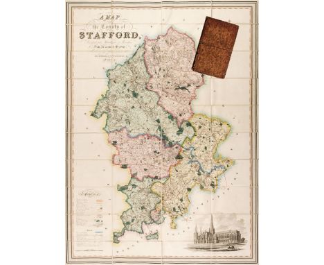
Lot 197
Staffordshire. Phillips (J. & Hutchings W.F.), A Map of the County of Stafford Divided into Hundreds & Parishes from an accurate Survey, made in the Years 1831 and 1832, Henry Teesdale, 1st August 1832, large scale map engraved by J. Dower with bright contemporary wash colouring, calligraphic cartouche, compass rose, table of explanation, inset uncoloured vignette of Lichfield Cathedral, edged in green silk, 1335 x 975 mm, marbled endpapers, contained in a contemporary blind-stamped tree calf book box with contrasting red gilt morocco label to the spine, worn and rubbedQTY: (1)
![* Wales. Speed (John), Caermarden Both Shyre and Towne Described, John Sudbury & George Humble [1627], hand-coloured engr](https://cdn.globalauctionplatform.com/f2d55b0d-bea0-4ba1-96c5-af5f00b8a264/9a552261-fde4-4af4-a6f7-af5f011e04fe/468x382.jpg)
Lot 209
* Wales. Speed (John), Caermarden Both Shyre and Towne Described, John Sudbury & George Humble [1627], hand-coloured engraved map, inset town plan of Carmarthen, large strapwork cartouche, compass rose and mileage scale, two very small rust holes, 380 x 510 mm, framed and double-glazed, English text on verso, together with The Countie of Radnor Described and the Shyre Townes Sittuatione, John Sudbury & George Humble, circa 1627, uncoloured engraved map, inset town plan of Radnor, large strapwork cartouche and mileage scale, slight staining and dust soiling, 385 x 515 mm, framed and double-glazed, English text on verso, together with Jansson (Jan). Radnoriensis comitatus vulgo The Countie of Radnor, Amsterdam, circa 1650, engraved map with contemporary outline colouring, later green crayon annotations (possibly roads), some creasing, slight overall toning, 370 x 480 mm, no text on verso, with Morden (Robert). South Wales [1695 or later], uncoloured engraved map central fold repaired on verso, 365 x 435 mm, with another coloured example, mounted, with another 21 maps of Welsh counties and regions, including examples by or after Kitchin, Badeslade & Toms, Cary, Seller/Grose, Saxton/Kip and Rocque, various sizes and condition, several framed and glazedQTY: (26)
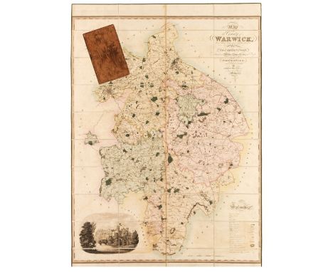
Lot 213
Warwickshire. Greenwood (C. & J.). Map of the County of Warwick from actual Survey, made in the years 1820 & 1821, Dedicated to the Nobility, Clergy & Gentry of the County by the Proprietors and Published for them by George Pringle Junr. C. & J. Greenwood. 1822, large-scale engraved map with contemporary wash colouring, sectionalised and laid on linen, calligraphic title, table of explanation, compass rose and uncoloured vignette of Warwick castle, very slight offsetting, edged in green linen, 1320 x 1050 mm, marbled endpapers, contained in a contemporary tree calf book box, some wear to extremitiesQTY: (1)
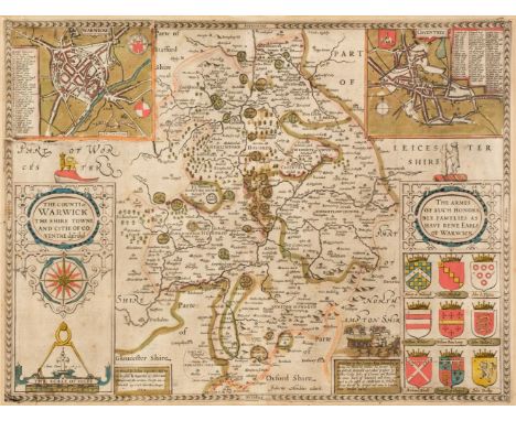
Lot 214
* Warwickshire. Speed (John), The Counti of Warwick, The Shire Towne and Citie of Coventre described, Roger Rea 1662, engraved map with contemporary outline colouring, inset city plans of Warwick and Coventry, large strapwork cartouche, compass rose and mileage scale, 385 x 510 mm, mounted, framed and double-glazed, English text on versoQTY: (1)NOTE:Scarce with contemporary colouring.
-
36463 item(s)/page