We found 112056 price guide item(s) matching your search

Refine your search

Year

Filter by Price Range
  • List
  • Grid
  • 112056 item(s)
    /page

Lot 444

A 9ct gold charm bracelet, the bracelet with oval bar links alternating to round links, to a half solid bolt ring clasp, 195mm long, Birmingham 1970, suspending thirteen charms, comprising a straw hat, a canoe, an Eire map, a royal carriage, a kangaroo, a goblet, a poodle, a kookaburra, a boxing glove, a spinning wheel, a harp and a dancer, all hallmarked or tested as approximately 9ct gold, and a gilt metal lion charm, 24.21g Condition ReportClasp secures.Marks and scratches to surfaces.Tarnish.

Lot 12

Clarendon, The Hon Hugh "A New and Authentic History of England ...", printed for J Cook, folding map, frontis engraved plates, rebacked with contemporary marble boards and quarter leather laid down Burke, Edmond "Reflections on the Revolution in France ...", 2nd edition printed for J Dodsley 1790, contemporary marble boards, half leather but loss and worn  Goldsmith, Oliver "A History of the Earth and Animated Nature", 2 vols, Blackie & Son 1876, colour frontis, numerous engraved plates, contemporary half leather, rather bumped and worn (5) 

Lot 23A

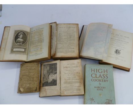
Cookery Raffald, Elizabeth "The Experienced Housekeeper, for the use and ease of ladies, housekeepers, cooks, etc ... dedicated to the Honourable Lady Elizabeth Warburton ..." London, published and sold by the booksellers and by T Wilson and R Spence, York 1805, new edition, frontis engraved portrait, three folding plates, offsetting to tp from the frontis, the first folding plate has extended the edges and is slightly creased, rebacked contemporary tree calf laid down, leather pastedown titles to backstrip [Rundell, Maria Elizabeth] "The Art of Cookery, made plain and easy ... by a lady", new edition London published for W Strahan, etc 1777, the boards are detached, ep and half title missing, some worm damage Glasse, Mrs "The Complete Art of Cookery ...", published and sold by Jones & Company circa 1840's, contemporary hand ink inscription on ffep, small 8vo, part of the backstrip is missing, the boards with titles Rhys, Marjorie "High Class Cookery", Longmans Green & Co 1928, blue cloth, dust wrapper price clipped [Rundell, Maria Elizabeth] "A New System of Domestic Cookery ... use of private families by a lady", John Murray 1837, engraved frontis, engraved plates, some damp damage throughout, contemporary full leather Denman, James L "The Vine and its Fruit ...", 2nd edition, Longmans Green & Co 1875, folding colour map frontis and another folding colour map, half morocco over boards, gilt rules, gilt titles, backstrip a little rubbed and bumped, t.e.g. (6)  

Lot 507

Diary of trips to Kashmir 1924-26-28 by RH Grazebrook, with detailed descriptions of his trips, accompanying photographs, maps, drawings, trade cards, list of marches and camps, equipment stores, camp kit, mileage expenses to include car journeys, Coolie expenses, camp kit, etc in one volume, two albums of further photographs of Kashmir July and August 1924, July and August 1926, album of black and white photographs of Kalaw, Burma with map and account of the Burmese holiday April and May 1939, with letters from Mr Grazebrook to his father, small quantity ephemera relating to the Gloucestershire Regiment including Royal Tournament souvenir pictures recollection of an historical display Olympia 1931 and photographs showing Lt Col Grazebrook in the Royal Fusiliers March and April 1941  Robert Michael Grazebrook O.B.E. M.C. 1st Bn Gloucestershire Regiment born 1893 Stourbridge, commissioned 1913, 1st Bn Gloucestershire Regiment, Gazetted for Military Cross January 1916, wounded twice, served in Ireland 1919 Gazetted for O.B.E. January 1923, India 1935, Burma 1939, Lt Col of 1st Bn Gloucestershire Reg returned to England 1940 o/c 15th Bn Royal Fusiliers 

Lot 106

John Ogilby - hand coloured strip map - "The Road from London to Chichester......" 37 x 50 cm, mounted, Hand coloured engraved map of A New and Correct Map of England and Wales, From the Latest and Best Improvements, engraved for Mrs Moore's New and Complete Collection of Voyages and Travels, 22.7cm x 33cm  Christopher Saxton (1540- 1610) & William Kip (1588-1635), a hand coloured engraved map of Flint, Comitatus quem Ordovices olim Incoluerunt, circa 1637 , 40cm x 33cm overall Christopher Saxton (1540- 1610) & William Kip (1588-1635), a hand coloured engraved map of Bedford, Comitatus olim pars Cathifuclanorum, circa 1607, 39.7cm x 33.3cm (4)

Lot 107

E Bowen & T. Kitchin, a partly coloured engraved map of Surrey, a double page from The Large English Atlas, published by Weinreb & Douwman, circa 1760, mounted, the map 73.5cm x 58.5cm, Coloured map of Dorsetshire by J. & C. Walker, listing polling places and places of foxhound meets, mounted, 39cm x 32cm (2)

Lot 105

Partially hand coloured map of The West Indies, plate CCLV, inscribed 'Encyclopeadie Brittanica 1797' verso, 29cm x 18.5cm exc. frame WITH Gerard Mercator, hand coloured engraved map of Crete and Greek Islands, late 16th century or later, showing six smaller Greek Islands, annotated in the border, mounted, the map 53.5cm x 41cm (2)

Lot 108

Four maps by Robert Morden - 'Map of the Kingdom of Ireland' sold by Abel Swale and John Churchill, 40 x 34 cm, framed and glazed, ' Kent' framed and glazed, 36 64 cm, 'The County of Monmouth' c.1695, 35 x 42 cm, framed and glazed and a 'Map of Bedfordshire', framed and glazed

Lot 101

Perrott, C L E "A Selection of British Birds Part 1", facsimile reprint, The Scolar Press 1979, elephant folio, colour plates with tissue guards, this is no.24 of a facsimile edition limited to 250 copies,  brown goatskin over hand marbled paper, with similarly bound prospectus, all within a quarter goatskin clamshell box Walpole-Bond, John "A History of Sussex Birds in Three Volumes", colour plates by Philip Rickman, HF & G Witherby Ltd 1938, brown boards, gilt titles to backstrip, all three with dust wrappers which have a pictorial pastedown to the front cover Borrer, William "The Birds of Sussex", RH Porter 1891, colour frontis with tissue guard, folding map, colour plates with tissue guards, frontis and ffep loose, red cloth with gilt titles Balston, R J, Shepherd, Rev C W and Bartlett, E "Notes on the Birds of Kent", RH Porter 1907, photographic plates, folding map at the end of the vol, 2 copies, green cloth, one bearing two bkpl and three other volumes (10)  

Lot 892

19th century hand drawn map - Plan of King's Fleet, in the parishes of Falkenham, Felixstowe etc. - Suffolk, the Property of George Tomline Esq, 46 x 107cm, glazed frame

Lot 891

Rare and large 18th century linen backed handcoloured map of Suffolk by Joseph Hodskinson, The County of Suffolk...Engraved and Published by William Faden, Geographer to the King (Successor to Mr. Jefferys), First edition, with inset plan of Ipswich, south west view of the Abbey Gate at Bury St. Edmunds, and diagram of principal stations, 1783, total size 122 x 163cmSome areas of considerable deterioration (see additional images) particularly on far left edge, small losses to periphery, map is mostly intact, some holes to backing at the folds, some marks and stains

Lot 896

Mid 18th century hand coloured engraved map by Emanuel Bowen, 'Suffolk Divided into its Hundreds', 52cm x 70cm, in glazed frame

Lot 228

James ENSOR (1860-1949), colour lithograph Miamia from the folder La gamme d'amour 1929, signed in the plateJames ENSOR (1860-1949), kleurlithografie Miamia uit de map La gamme d'amour 1929, getekend in de plaat26.5 x 20.5 cm

Lot 226

James ENSOR (1860-1949), lithograph from the series Scènes de la vie du Christ, Le Christ chassant le Démon du corps d'un possédé , signed in the plate, folder no 257James ENSOR (1860-1949), lithografie uit de reeks Scènes de la vie du Christ, Le Christ chassant le Démon du corps d'un possédé , getekend in de plaat, map nr. 25718 x 23 cm

Lot 1230

Guy LECLERCQ (1940), Tabulae 2013, suite of 4 Negrita prints on Hahnemühle, in silver-stamped linen folder, with title page and colophon page, numbered 11/18 and signedGuy LECLERCQ (1940), Tabulae 2013, suite van 4 Negrita drukken op Hahnemühle, in een linnen map met zilverstempeling, met titelpagina en colofonpagina, genummerd 11/18 en getekend

Lot 1174

Folon and Alechinsky, folder FOLON with eau forte et aquatint X/L, signed and book Entre Zut et Zu with etching Pierre ALECHINSKY, numbered 26/51 and signedLot Folon en Alechinsky, map FOLON met eau forte et aquatint X/L, getekend en boek Entre Zut et Zu met ets Pierre ALECHINSKY, genummerd 26/51 en getekend15.5 x 10 & 15.5 x 13.5 cm

Lot 1175

Pierre ALECHINSKY (1927), Folder with lithographs (3) Je vous en prie, numbered 45/99 and signedPierre ALECHINSKY (1927), Map met lithografiën Je vous en prie (3), genummerd 45/99 en getekend32.5 x 25 cm

Lot 1226

Jean-Marie PLANQUE (1932-1992), folder of original works, signedJean-Marie PLANQUE (1932-1992), map met originele werken, getekend

Lot 1249

A Map of the 'North Perspective of the Town of Sheffield', engraved by H. White,42 x 70cm.Another 'The East Prospect of Sheffield in the County of York,32 x 82cm. (2)

Lot 1348

An Edwardian Pair of Cased Sets of Bartholomew's Road Maps for England and Wales and Scotland, in brown crocodile skin cases, each with brass lock and catches, initialled 'J.W' to lids, the interiors compartmentalised with linen-backed folded maps, 37 for England and Wales and 29 for Scotland (each case missing the contour map book), with measuring wheels and keys.

Lot 655

Queen - The Complete Works (EMI QBI, 1985), contains fourteen LPs, Works booklet, World Tour Itinery 1971 - 1985, and Queen map of the World, This is the version with the 'Complete Vision' album as a 33rpm lp. All lp's are Nm except Hot Space, which has a minor surface mark.

Lot 190

An 1877 street map - plan of Penzance, two 1877 linen backed maps of Gulval/Madron and Madron/Sancreed and one other local plan (4)

Lot 1201

A silk services map for French Indo-China, book relating to British Infantrymen in the Far East 1941-45 and one other (3)

Lot 170

An 18th century hand coloured map "The East Riding of Yorkshire" by Robert Morden

Lot 169

A 19th century hand coloured map of the county of Huntingdon by C and J Greenwood 1831, framed and glazed

Lot 180

A 17th century hand coloured map of Cornwall by Jan Jansson circa 1646 17" x 21½"

Lot 106

A reprinted Doomsday Book of Cornwall with additional introduction, translation and map volumes 1987 in slip case

Lot 179

An 18th century hand coloured map of Cornwall by Thomas Kitchin "A New Improved Map of Cornwall from the Best Surveys and Intelligences Divided into it's Hundreds" from the Large English Atlas 1755 21½" x 28"

Lot 245

Egone Schiele print, the artist's wife seated, and antiquarian style map of Gloucestershire

Lot 414

A WWII silk flying map of France and Spain, 52 x 59cm a German silk map, with Bulgaria - Romania and Greece to the verso, 48 x 59cmand a button 'escape' compass (3)

Lot 508

A collection of prints and watercolours, to include a Durham road map and pond birds

Lot 345

A color map depicting the land and sea area of the Sombrero Key to the Sand Key. Publishing stamp by "The U.S Coast and Geodetic Survey" located on bottom. Issued: 20th CenturyDimensions: 44"L x 36"WManufacturer: U.S Coast and Geodetic SurveyCountry of Origin: United StatesCondition: Age related wear.

Lot 344

Depicts a colored map of land and waterways from East Cape to Mormon Key. Publishing stamp by "The U.S Coast and Geodetic Survey" located on bottom. Issued: 1932Dimensions: 44"L x 36"WManufacturer: U.S Coast and Geodetic SurveyCountry of Origin: United StatesCondition: Age related wear.

Lot 310

Full title: An Improved Map of Asia, With all the Discoveries that have been made to The Present Time. Detailed political and physical map of Asia. Includes major countries such as the Russian Empire, China, India, Arabia, Japan, and Korea (spelled Corea). Originally printed for the Universal Magazine of Knowledge and Pleasure (active 1747-1814), a successful periodical during its time created by John Hinton. A fascinating piece of history considering these periodicals and books were the only way the Western general public could educate itself about lands beyond the Western world. Issued: 18th c. Dimensions: 14.25"L x 12.25"WManufacturer: The Universal Magazine of Knowledge and PleasureCountry of Origin: EnglandCondition: Age related wear and tears.

Lot 311

Full title: An Accurate Map of India beyond the Ganges, with the Oriental Islands generally call'd East India. From the latest Improvements. Engraved political map with names of countries, cities, large bodies of water, and rivers. Originally printed for the Universal Magazine of Knowledge and Pleasure (active 1747-1814), a successful periodical during its time created by John Hinton. Lower right text reads, R.W. Seale del. et sculp. Issued: ca. 1743Dimensions: 14.5"L x 12"WCondition: Age related wear.

Lot 303

Fascinating historical engraved map originally drawn by prolific 18th-century geographer T. Jefferys. The map shows not only the political division in Africa in the 18th century but also tribal regions. Map also identifies the "Slave Coast" just north of what is now the Gulf of Guinea. Text in lower left corner reads: Africa Drawn from the best Maps by T. Jefferys, Geographer to his Royal Highness Prince of Wales. Printed for Gentleman's Magazine in 1748. Artist: Thomas JefferysIssued: ca. 1748Dimensions: 9"L x 10"WManufacturer: Gentleman's MagazineCondition: Age related wear. Top border of map missing.

Lot 314

Engraved map depicting the lands of Australasia. Australia is shown as being labeled New Holland, which was the name of the continent up until its renaming a few years after the printing of this map in 1817. On the bottom border from left to right the following information can be found: Drawn under the direction of M. Pinkerton by L. Hebert; London: Published April 15th, 1813 by Cadell & Davies Strand & Longman, Hurst, Rees, Orme, & Brown Paternoster Row. Artist: L. HebertIssued: 1813Dimensions: 22"L x 31.5"WCondition: Age related wear, stains, and minor tears.

Lot 309

Full title: Carte Geo-Hydrographique du Golfe du Mexique et de ses Isles. Construite d'apres les memoires le plus recens, et assujeties, pour l'emplacement de ces principales positions aux latitudes et longitudes, determinees par observation. Antique hand-colored map depicting the Gulf of Mexico. Includes soundings, names of countries, rivers, and large bodies of water. Another engraved print of this map can be found in the Library of Congress collection. Artist: Rizzi-Zannoni, Giovanni Antonio, Lattre JeanIssued: ca. 1762Dimensions: 13.5"L x 18.5"WCondition: Age related wear and small holes.

Lot 341

Antique advertisements for a Florentine jeweler and souvenir maker D. Chirli. Includes description of company on front of pamphlet in 3 languages and map of Florence. Each measures 5"L x 3.5"W. Issued: ca. 1920Condition: Age related wear.

Lot 307

Full title: A map of the South Pole, with the track of His Majesty's Sloop Resolution in search of a southern continent. A fascinating historical map tracking the HMS Cook's journey in search of the southernmost continent. Map documents James Cook's most southerly exploration point at 71 degrees. Antarctica would not be sighted until 1820 by a Russian expedition. T. Bowen Sculpt. printed to the lower right. Thomas Bowen (b. c. 1733-1790) was the son of Emmanuel Bowen, who was in service as the Royal Mapmaker to King George II and Louis XV in France. Thomas Bowen fell from grace and was jailed as a debtor in 1761 and died in the Workhouse in Clerkenwell, a home for the impoverished. Artist: Thomas BowenIssued: ca. 1776Dimensions: 10.25"L x 9.5"WManufacturer: Gentleman's MagazineCountry of Origin: EnglandCondition: Age related wear. Royal Mapmaker to both to King George II of Great Britain and Louis XV of France

Lot 304

Title: Plan of Lucia Harbour and Mantega Bay. Antique engraved map detailing early English plans for Lucia Harbour and Mantega Bay in Jamaica. Details soundings (water depths), anchorages, and location names. Sayer & Bennett was a partnership of Robert Sayer and John Bennett. They specialized in American atlases and were one of the largest providers of British charts during the 18th century. Their work was drawn on plates by Thomas Jefferys, who was a prolific geographer in the 18th century. Issued: ca. 1794Dimensions: 8.5"L x 10.75"WManufacturer: Sayer & BennettCountry of Origin: EnglandCondition: Age related wear.

Lot 315

The engraved Map of Tampa Bay is a coast survey reconnaissance by the Hydrographic Party under the command of Lieut. O.H. Berryman U.S.N. Assist. Dimensions: 7.5"L x 24.5"H. Also including an engraved map of the U.S. Coast survey of the Western Coast of Florida. Dimensions: 5"L x 24.5"H. Issued: 1848-1855Country of Origin: United StatesCondition: Age related wear.

Lot 316

Original 1950s Miami Beach concert, minstrel and shows programs; Key West postcard and map, and beach photographs. Smallest item size: 3.50"L x 2.75"H. Largest program sizes: 6"L x 9"H. Issued: c. 1950Dimensions: See DescriptionCountry of Origin: United StatesCondition: Age related wear.

Lot 301

Engraved print in black ink with some hand-coloration. Map is printed on two pages joined in the center. Map depicts the Holy Land with unique illustrations including where Saul fell off his horse, Abraham's Pilgrimage (titled and described in Latin in the lower left quadrant), and other religious sites. Major roads, topographical features, and villages are also included. Attributed to Jan Jansson and Georgius Hornius, two 16th-century engravers. Artist: Jan Jansson/Georgius HorniusIssued: 16th-17th c. Dimensions: 21.25"W x 18"HCondition: Age related wear.

Lot 308

Full title text: A new Projection of the Western Hemisphere of the Earth on a Plane (showing the proportions of its several parts nearly as on a Globe) by J. Hardy (Teacher of Mathematics & Writing Master) at Eaton College. A captivating museum-quality map published on May 1st, 1776, a few months shy of the day the United States gained its independence from England. The map identifies political divisions, bodies of water, and rivers. Text on bottom border reads, Publish'd According to Act of Parliament, by F. Newbery, Ludgate Street May 1st, 1776. Artist: J. Hardy/Thomas BowenIssued: 1776Dimensions: 11"L x 9.5"WManufacturer: Gentleman's MagazineCountry of Origin: EnglandCondition: Age related wear.

Lot 306

Historical engraved colored political map of 19th-century Brazil. Details natural features such as rivers and mountains as well as political and administrative divisions. Printed on lower border: Published, March 1st, 1822, by Sherwood Neely & Jones, 20 Paternoster Row, London. Issued: 1822Dimensions: 15.25"L x 10.25"WManufacturer: Sherwood Neely & JonesCountry of Origin: EnglandCondition: Age related wear. Stain to right border.

Lot 312

Full title printed within embellished border: A Map of the Island of Dominica, taken from an actual Survey. Also part of Martinico & Guadalupe showing their true bearing & true distance from each other. By Thomas Bowen. Map identifies political borders, physical natural details, major bodies of water, and rivers. Created for Gentleman's Magazine December 1778, v. 48. This same engraving resides within a collection at the Library of Congress. Artist: Thomas Bowen/E. CaveIssued: 1778Dimensions: 10.5"L x 8"WManufacturer: Gentleman's MagazineCountry of Origin: EnglandCondition: Age related wear, tear, and stains.

Lot 305

Title: A Plan of the Entrance of Tampa Bay on the West Coast of Florida. A fascinating and historic map of early plans for Tampa Bay detailing soundings measured in fathoms and feet (water depths), key names, and bodies of water. Robert Sayer was a prolific provider of British charts and maps in the 18th century. Many of his maps were based on the plates of well-known geographer Thomas Jefferys; he obtained the plates after Jefferys went bankrupt in 1766. A great addition to any collector who enjoys Florida history!Issued: 18th c. Dimensions: 8.25"L x 11"WManufacturer: Robert SayerCountry of Origin: EnglandCondition: Age related wear. Scotch tape on lower edge. Minor impressed scrape to lower left quadrant.

Lot 313

Etching print attributed from book titled Travels, or Observations Relating to Several Parts of Barbary and the Levant by Thomas Shaw. Print depicts The Peutinger Map which displays the road network of the Roman Empire. The heraldic cartouche on the top left corner reads, Auspiciis Viri Reverendi Ioannis Burton S.T.P. Issued: 18th c. Dimensions: 18"W x 13.75"HCondition: Age related wear.

Lot 302

Historical antique engraved political map predating the Suez Canal built in 1869. Map illustrates military and other man-made structures, roads, and mountains. Includes Governor's Gardens, The Grand Barracks, signal house, and a hospital on the eastern side of the map. Mounted on a brown matte board. This small isthmus on the southern coast was hotly contested between the British and the Spanish during the 16th and 18th centuries. Dated on top right Gent. Magazine March 1762. The Gentleman's Magazine was a monthly magazine founded in London, England, by Edward Cave in January 1731. Issued: 1762Dimensions: 9"L x 20"WManufacturer: Gentleman's MagazineCondition: Age related wear and damage. Loose from matte board border. Has scotch tape on back.

Lot 342

This group of original engravings include: a small sketch of the survey of the Coast of Florida and Cedar Key Bay; a chart of St. Andrews Bay; A costal survey of the Florida Reefs; and a large Sketch of the Florida Gulfstream. Largest map dimensions: 23" L x 21" H. Smallest map Dimensions: 9"L x 10.25"H. Issued: 1855Country of Origin: United StatesCondition: Age related wear.

Lot 317

Group of five original antique engravings on brown paper published in The Universal Magazine of Knowledge and Pleasure by John Hinton in 1747-1758. They include: The Aelian Bridge and Castle of St-Angelo in Rome; The New Grand State Procession of the New Doge of Venice; The N.E Side of the Fort on the Island of Aix in 1758; A Chart of the Pacific Ocean; and Plans of the Fortifications in Luxemburgh and Maestricht, A Method to Cast Bombs into a Town and Map of the Island of Corsica. Average engravings dimensions: 10"L x 8"H. Issued: 1747-1758Dimensions: See DescriptionCountry of Origin: EnglandCondition: Age related wear. Sporadic soiling, foxing, and tears. One part of the Chart of the Pacific Ocean is missing and the folds have been taped.

Lot 128

Solid brass case with a gimballed casing to pivot angle. World time bezel will turn to calculate the time difference in hours representing 24 time zones. Polished Brass Geo-map of the world is embedded into the black dial. Powered by one "AA" battery. Seiko mark on rim. QHG106GLH. Issued: 21st centuryDimensions: 4"L x 2.5"W x 5.25"HManufacturer: SeikoCountry of Origin: JapanCondition: Age related wear. Untested, clock functionality not guaranteed.

Lot 184

A John Speede Map of Breknoke, both shyre and twone described ann. Domini 1610, later hand coloured together with a Saxton map of Breknoc

Lot 119

Walter Horshell, Looking Down the Dales, signed, watercolour, 50cm x 74cm; Les Ambler, Pooh Sticks, by the Pub, signed, watercolour, dated 1986, 27.5cm x 40cm; Pencil Sketch, The George & Dragon, Apperley Bridge, 28cm x 22cm; H Thompson, Above Threshfield, signed oil on board, dated 1967, 50cm x 60cm , John Cary Map, Yorkshire etc (7)

Lot 690

Army L.S. & G.C., G.V.R. (2), 1st issue (7732426 Cpl. C. L. Winter. R.M.C.); 3rd issue, Regular Army (3592469 Bdsmn. H. G. Preece. R.M.C.) contact marks and polishing to first, this fine, the second very fine (2) £70-£90 --- Cyril Launcelot Winter was born in West Hackney on 21 February 1888 and is recorded in 1911 as a Musician in the 1st Battalion, North Staffordshire Regiment. Awarded the Long Service and Good Conduct Medal whilst serving at the Royal Military College, he later took employment as a map store keeper for the Ordnance Survey, and died at Southampton on 19 December 1945.

Lot 900

Commemorative Zeppelin Badge. A commemorative pin badge for the round the world flight of the German airship D-LZ 127 Graf Zeppelin from 8 to 29 August 1929; large white metal example bearing black title circlet ‘Friedrichshafen. Tokio. Los Angeles. Lakehurst.’ with an applied lightly domed centre displaying a map North and South America with the letters 'L-A' for (Los Angeles) and 'L' for (Lakehurst NJ); the reverse impressed with German maker's details ‘F’ ‘L’ ‘L’ each letter in a circle 'Friedrich Linden Ludenscheid'., with original pin fitting; together with a French Bombardier Brevet badge with two lugs, white metal laurel wreath and gilded wing, star and bomb, with maker’s mark for Drago, Paris; and a white metal Monarch Steamship Co. Ltd., ‘White Star Line’, cap badge, good condition (3) £90-£120

Lot 796

An old map of Swansea, 70cm (h) x 70cm (w) / All lots are located at Gower Reclamation, Unit 17b, Crofty Industrial Estate, Gower, Swansea, SA4 3RS. Regretfully Wellers are unable to offer any type of shipping, please see our important information for collections information.

Lot 141

A pair of Royal Presentation 9ct gold and enamel World Tour cufflinks, presented by H.R.H. Prince Philip, Duke of Edinburgh to Walter Bennett, his personal chauffeur, the oval plaques with crowned initial P against green enamel ground, the second plaque with white, blue, red and green enamels depicting the world tour logo, a map of Antarctica, with the date 1956-1957, beneath crown, with chain connectors, maker’s mark H.H.P. for Henry Hodson Plante, hallmarked for Birmingham 1956, in original fitted case by Plante, with gilt embossed Royal cypher to the lid, plaque length 17.5mm. Accompanied by a letter from Buckingham Palace written on behalf of the Duke of Edinburgh dated 31 May 1957, reading: “Dear Walter The Duke of Edinburgh has asked me to send you the enclosed photographs and cufflinks with his sincere thanks for all you did during his recent tour. Yours sincerely” signed by Lieut.-General Sir Frederick A.M. Browning KCVO, KBE, DSO, together with a photograph of the Royal Staff on board the Royal Yacht Britannia with printed signature of the Duke of Edinburgh, a copy of a photograph of the Full Ship’s Company, and negatives and personal photographs of the Tour taken by Walter Bennett. £500-£800 --- Provenance: Walter Bennett was personal chauffeur to the Duke of Edinburgh between 1949-1963. The World Tour of 1956-57 started at the 1956 Olympic Games in Melbourne, Australia, and continued to New Zealand, Antarctica, the Falkland Islands, Africa and the Mediterranean. Prince Philip travelled in the newly commissioned Royal Yacht Britannia, the lengthy trip covering 38,000 miles. Condition Report Surface wear evident to the enamel panels commensurate with use. Some wear to the case exterior. Weight 14.2gm.

Lot 163

John Fairburn (1789-1840) Fold out hand-coloured detailed plan of "London and Westminster", seventh edition dated 1802, with inset map of the "Enlarged Plan of the Rules of Fleet Prison" illustrating Fleet Prison, Newgate, Keepers House, Felons Door, Sessions House, City Barracks, & St. Martins Church. Alphabetical list of 300 principal streets, with letters of reference to their situation in bottom margin. The title in the upper right corner overlays a large vignette scene depicting the reclining figure of Father Thames, framed and glazed, image size 44cm x 80cm Condition Report Map does not appear to mounted on card. It does appear to have a linen/canvas backing to it. 

Loading...Loading...
  • 112056 item(s)
    /page

Recently Viewed Lots