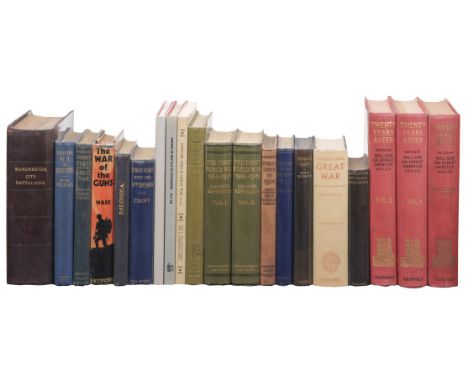
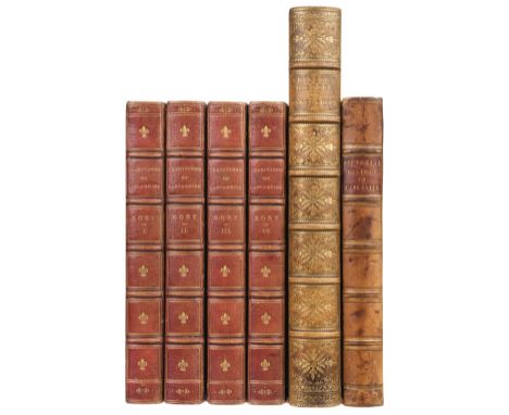
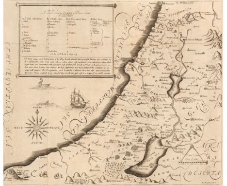
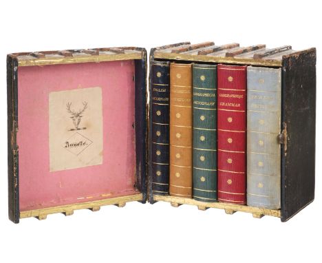
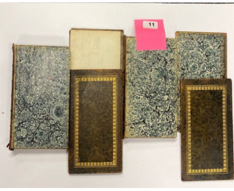
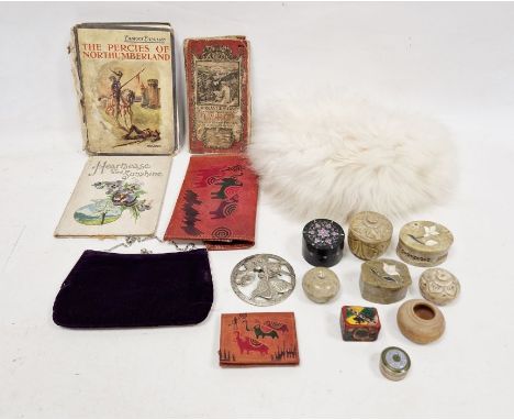
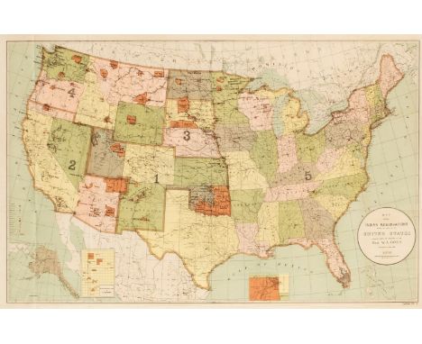
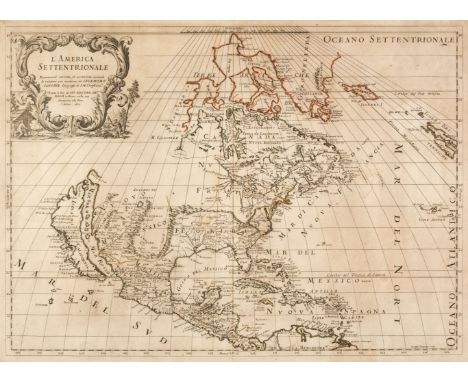
Book Box. A decorative book box containing a mixed set of dictionaries and grammars etc., early 19th century, morocco covered book box in the form of a set of five volumes (replicating contents) with gilt finishing, lid to box with armorial crest bookplate depicting stag's head with ink name Annette below, leather hinge to lid partly split, rubbed, volumes contained in book box comprise:1. A Dictionary of the English Language, with an Alphabetical account of the Heathen Deities; and a list of the Cities, Towns... in England and Wales. To which is prefixed a comprehensive view of English Grammar, 5th edition, London: W. Peacock, 1797, front blank with contemporary signature Annette Bradford, occasional spotting, all edges gilt, contemporary navy straight-grain crushed morocco, lightly rubbed, 12mo in 6s,2. Jones (Stephen), A new Biographical Dictionary: containing a brief account of the Lives and Writings of the most Eminent Persons and Remarkable Characters in every Age and Nation, 3rd edition, corrected, London: Printed by T. Bensley, for G.G. and J. Robinson, J. Wallis, J. Scatcherd, W. Peacock, and E. Newbery, 1799, date to title imprint cropped, front blank with contemporary signature Annette Bradford, all edges gilt, contemporary tan brown straight-grain crushed morocco, 12mo in 6s,3. A Compendious Geographical Dictionary, containing, a concise description of the most remarkable places, Ancient and Modern, in Europe, Asia, Africa, & America ... to which are added, a chronological table from the creation to the present time; a monthly list of all the fixed fairs in England and Wales; and a tale of the coins of the various nations, and their values in English money. To the whole is prefixed, an introduction, exhibiting a view of the Newtonian system of the planets, &c., 2nd edition, London: W. Peacock, 1795, folding engraved World map frontispiece and five folding maps, each with contemporary hand-colouring in outline, one folding engraved 'view of the Solar System', front blank with contemporary signature Annette Bradford, all edges gilt, contemporary turquoise green straight-grain crushed morocco, small area of leather to rear board skinned, 12mo in 6s,4. A Compendious Geographical and Historical Grammar: exhibiting a brief survey of the Terraqueous Globe ... and also, a concise view of the Political History of the several Empires, Kingdoms, and States, 2nd edition, corrected, London: W. Peacock & Sons; J. Scatcherd, 1802, folding engraved World map frontispiece and 12 folding maps, each with contemporary hand-colouring in outline, occasional light toning and scattered spotting, front blank with contemporary signature Annette Bradford, all edges gilt, contemporary red straight-grain crushed morocco, 12mo in 6s,5. Tocquot (J. F.), The Royal Pocket Dictionary, French and English, and English and French: containing the signification of words in all their different acceptations; the terms of arts, sciences, and trades ... also a general table of the value of all the monies in Europe reduced to the English and French standards, London: G.G. and J. Robinson, H. Gardner, Ogilvy and Speare, R. Faulder, J. Debrett [& others], [1795], English and French titles, some light toning, front blank with contemporary signature Annette Bradford, all edges gilt, contemporary pale turquoise crushed morocco, 12mo in 4sQTY: (1)

![* Persia. Mercator (Gerard / Hondius Jodocus), Persici Vel Sophorum Regni Rypus, [1606 - 30], engraved map with sparse contem](https://cdn.globalauctionplatform.com/14d4f542-a179-4b38-b79b-afa100a4c073/68d990ee-5596-4395-b84a-afab010b6453/468x382.jpg)
![* Persia. Speed (John), The Kingdome of Persia with the cheef Citties and Habites described, George Humble [1627], hand-colou](https://cdn.globalauctionplatform.com/14d4f542-a179-4b38-b79b-afa100a4c073/86895e5f-a7eb-4460-91cf-afab010b6528/468x382.jpg)
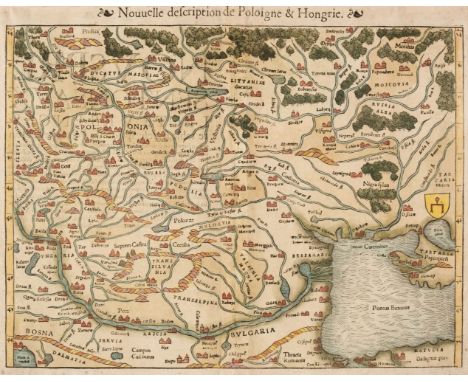
![Poland. Ortelius (Abraham), Poloniae Finitimarumque Locorum Descriptio Auctore Wenceslao Godreccio Polono [1579], hand-colour](https://cdn.globalauctionplatform.com/14d4f542-a179-4b38-b79b-afa100a4c073/62b4e29e-b435-45f9-8cec-afab010b6652/468x382.jpg)
![Poland. Speed (John), A Newe Mape of Poland done into English..., Thomas Bassett & Richard Chiswell [1676] hand-coloured](https://cdn.globalauctionplatform.com/14d4f542-a179-4b38-b79b-afa100a4c073/ff92f847-06cd-4ae0-b13c-afab010b6727/468x382.jpg)
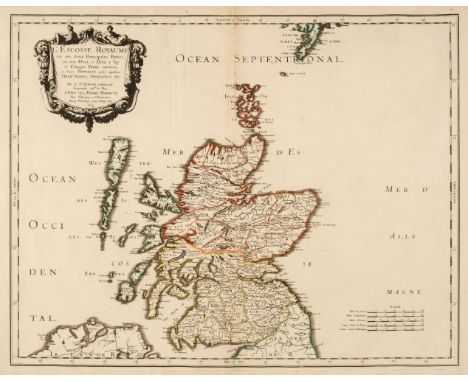
![Scotland. Speed (John), The Kingdome of Scotland, Thomas Bassett & Richard Chiswell [1676], hand-coloured engraved carte-](https://cdn.globalauctionplatform.com/14d4f542-a179-4b38-b79b-afa100a4c073/cd4eb224-4ee3-4fb5-a8be-afab010b681e/468x382.jpg)