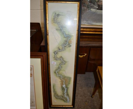
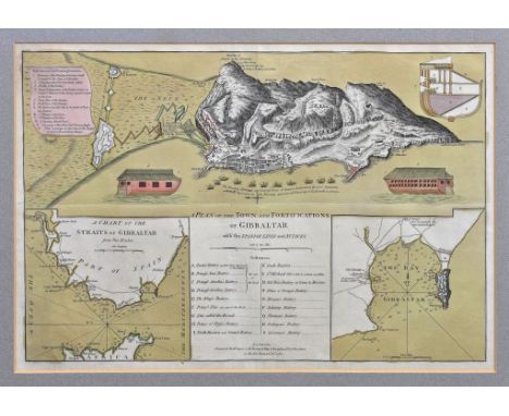
We found 117892 price guide item(s) matching your search

Refine your search

Year

Filter by Price Range
  • List
  • Grid
  • 117892 item(s)
    /page

Lot 531

Sayer (Robert) and Bennett (John), A Plan of the Town and Fortifications of Gibraltar with the Spanish Lines, &c., engraved map with inset charts and references and pictorials of the Floating Batteries, with hand colouring, c.1782, 13½ x 20 3/8in. (34.25 x 51.75cm.), framed and glazed; together with a 19th century coloured print of 'The Calpe Hunt Steeplechase, Gibraltar'. (2) * Not examined out of frame. Central horizontal and vertical fold creases. Light mount burn. Sheet slightly cockled and light crease lower left. Clean and bright overall.

Lot 539

Albrizzi (Giovanni Battista) - Carta Generale Deli Africa, Venice c.1750, double page engraved map with hand colouring, decorative title with hunting scene, 13 x 16¾in. (33 x 42.5cm.). * Provenance: The Map House, Beauchamp Place, London SW3 ** Vertical centre fold. Clean and bright overall, with a little surface dirt and two square tape adhesive marks visible to verso of paper at upper corners.

Lot 551

Zatta, Antonio (1757-1797), 'Le Indie Orientali e il Loro Archipelago', engraved map of Indonesia, pub. Venice 1784, with hand coloured outlines, border and scroll title, 13¼ x 16¼in. (33.7 x 41.25cm.); together with another engraved map by Zatta, 'Regno di Portugallo, pub. Venice 1775, with decorative title and hand colouring, 15½ x 10 3/8in. (39.4 x 26.3cm.). (2) * - Indonesia: Vertical fold to centre, with some associated small creases at lower margin. Otherwise good. - Portugal: Horizontal fold to centre, some handling creasing to lower quarter of sheet. Otherwise good.

Lot 552

Maurepas (Count de), A Chart of the Coast of Arabia, the Red Sea & Persian Gulf, drawn from the Chart of the Eastern Ocean, Published in 1740, by Order of ye Count de Maurepas...., engraved map with hand colouring, compass rose and decorative title cartouche, 8 7/8 x 10in. (22.5 x 25.4cm.). * Central vertical fold. Otherwise clean and bright.

Lot 555

Brue (Adrien Hubert) - Africa, Carte Generale des Etats du Nord de L'Afrique, de la Mer Mediterranée et de L'Europe-Méridionale, engraved map with hand coloured outlines and sea, blind stamp below title, 14¼ x 20 1/8in. (36.25 x 51.2cm.); together with two other 19th century maps of West Africa. (3) * - Brue: Mount burn. Sharp vertical page fold to centre. Paper slightly cockled. - Two maps of West Africa: Light mount burn but otherwise good.

Lot 6

A rare German Kriegsmarine map of the Channel Islands depicting all of the Islands and the French coast, with original document stamps with Eagle and Swastika to front and reverse, the map titled and dated "DER KANAL FRANKREICH, NORDKÜSTE ST GERMAIN BIS CHERBOURG UND KANAL INSELN MASSSTAB 1:150000 HÖHEN UND TIEFEN IN METERN 1907", the bottom of map with "Herausgegeben vom OBERKOMMANDO DER KRIEGSMARINE, Berlin 1907, with highlighted navigational beacons / lighthouses throughout, 30 x 32¾in. (76.2 x 83.2cm.). *The map with stains, edge wear, small rips on folds etc, overall good.

Lot 462

Robert Morden (1650-1703) - 'Hampshire' inscribed with the county name and the cartographer's name within a decorative cartouche also showing part of the Isle of Wight, hand coloured map 14.25" x 16.5"

Lot 463

John Ogilby (1600-1676) - 'The Roads From London to Bath & Wells in The County of Somerset' extensively inscribed within a decorative cartouche, hand coloured map, 14.5" x 18.75"

Lot 58

Formula One Mercedes framed Blueprint and Medal Set rare item not available to the general public team issue only 2017 includes A team issue blueprint hand signed by Lewis Hamilton, Valteri Bottas, Toto Wolf, James Allison and Andy Cowell complete and displayed limited edition 645 of 2150 team medal set for the 2017 season comprising of twelve medals with a map of each circuit and the finishing position of the Mercedes driver in each race. Two Large medals celebrating Lewis Hamilton championship win with an engraved signature and race statistics. Good condition Est.

Lot 430

George Philip and Sons Ltd, Dunkirk to Berlin June 1940 to July 1945: Journeys Taken by The Rt. Honble. Winston S Churchill OM CH FRS MP Prime Minister of Great Britain, In Defence of the British Commonwealth and Empire, map print published by The London Geographical Institute, frame size 99cm x 124cm

Lot 327

Local quarrying interest - Horton Wood Stone Firms Ltd, Middleton Quarry engineers drawing by Lewis & Lewis Mining Engineers, Surveyors, Derby 1932; a map of Middleton and Wirksworth quarries, second edition 1899, Derbyshire Sheet XXXIV; a smelter?s spoon; two scratch built wooden pulleys.(5)

Lot 280

A framed and glazed map of Lincolnshire, and a smaller map of Norfolk, along with two oil paintings, one depicting a coastal scene with windmill and birds in flight, artist monogram BD, a relief picture of an Asian deity dancing, probably Thailand, and a framed and glazed printLocation: CB

Lot 38

A vintage black painted metal deed/strong box 24cm h x 37cm w x 27cm d, together with a map of Mount Everest and the Group of Chomolungma Location: 2:4

Lot 981

Toyne Needlework Collection - a George III needlework sampler, ebroidered with a map of England showing the counties, 39.5cm x 31cm, framed

Lot 111

Rome Area Allied Command Engineer. Signed Authorization for military vehicle to be used transporting stores to Rome (September 1944), Two sided coloured street map of Rome, unusual Magazine style Italian publication "Coccarde Tricolori" covering Italian aviation after the "Liberazione", excellent illustrations, much in colour and what appears to be a memorial double page of Pilots etc who were lost in the war, opening door with crosses, etc. 5 items,

Lot 13

Silk Escape Map, double sided Vilnyus Minsk 4th Edition & Amsterdam-Hamburg-Berlin- Warsaw. First Edition 1953. Very good condition (one map)

Lot 150

Geographical Plan of The Island & Forts of Saint Helena by Lieut R P Read and Retailed by Burgis & Barfoot, London 1815, the island orientated with north to the lower left corner, with Napoleon's residence incorrectly identified at Plantation House in the centre of the island, with facsimiles of Napoleon's signatures in the lower right corner, engraved map by Kirkwood, with early hand-colouring, dissected and mounted on linen, with descriptive engraved text verso, folding into its original card slip-case with title label and reverse with label showing image of Napoleon in Egypt. Some wear to both the map and the case but still a good example.

Lot 151

Rare India Punjab Sikh War Map by James Wyld 1846, the hand coloured fold out map, “TO THE RT HONBLE SIR HENRY HARDINGE LIEUT GENL G. C. B. GOVENOR GENERAL OF INDIA- THIS MAP of the Routes through the PUNJAB AND THE ADJOINING STATES – Charing Cross East London is dedicated by his Obt & Obliged Servt JAMES WYLD”. To the bottom of the map is “PUBLISHED BY JAMES WYLD GEOGRAPHER TO THE QUEEN & H.R.H PRINCE ALBERT. CHARING CROSS EAST. MARCH 2ND 1846”. Folds into hardbound book style cover with the original label to the front, “WYLD’S THEATRE OF WAR IN THE PUNJAB” remains of a wax seal to the centre. Generally good example.

Lot 152

Scarce India Sikh War Sketch of the Battle of Chilleanwala (Chillianwala) 1849 Published by James Wyld, small hand coloured folding map / sketch of the “Battle of Chilleanwala Between the Sikh Army under Shere Singh and The Army of the Punjab, under the Personal Command of H. E. Lord Gough, Commander in Chief on the 13th Jany 1849”, stated to have been “Drawn by E Haythorne Capt 98th Regt A.D.C. to Genl Campbell CB. Camp Chilleanwala 29th Jany 1849”. Bottom section printed “LONDON PUBLISHED BY JAMES WYLD GEOGRAPHER TO THE QUEEN CHARING CROSS EAST & 2 ROYAL EXCHANGE MARCH 27th 1849”. Folds into hard bound covers with the original paper label to the front. Generally good example.

Lot 154

Great War Trench Map France, sheet 28 S.W Edition 5A, scale 1/20,000, Zone CALL W.X.Y.Z. Linen backed map with the trenches corrected to 1-4-17. Remains in good condition. Accompanied by 8 WW1 period linen backed topographical maps of France and Belgium. (9 items)

Lot 182

Important Collection of Original Photographs of the North Russian Expedition 1919/20, believed taken by a British Officer, Captain Bernard Hughes, (served with 3rd North Staffs Regiment). Images include group photographs of British, Italian, American, Chinese? Polish, and French troops. Others of British Officers, including General Ironside. Also street scenes, parades, Commercial School, used as some form of HQ (26/1/20), YMCA with Americans formed up outside, US troops received awards, Japanese Officer Capt R.Nakagawa (Siberia), British Officers, one Naval with Secretary? seated in front of large map, corpse laid out presumably a casualty and probably from the opposing force etc. etc. Other images may have been taken in China Etc. Most are unmounted, three have been neatly removed from an Album. Together with OBE Warrant to Captain Hughes dated October 1920. In total some 64 images of various sizes and mostly very clear, a few with captions, of which 50 are of Russia.

Lot 210

Mixed Group of US War Department Maps, Fiji Islands, 1943 1 inch to 1 mile, Nanuya, Ndakuinuku & Nasau. Also New Britain Mt Talawe (Special Map), Mt Bango, both 1943, together with Northwest New Guinea again 1943, ( 6 maps in all )

Lot 246

Maps AMS T791 1st Editions 1:50K Bismarck Archipeligo, one of Gazelle with an aerial photograph as part of the map, etc. 7 sheets,

Lot 293

Maps, Tripoli 1:100,000 General Staff 1935 from an Italian map, linen and others from 1942 Bir Gattar, Cabao etc.14 in all.

Lot 51

Military Books, Mainly Great War, including Tanks since 1916, March On Paris, von Kluck (lacking map), Memorial Album 1914-1918 (Lloyds Bank) and others (19 in all)

Lot 54

Bangalore, "On The Spot" MCMXLII (1942) Volume I Number III Military School Journal with Detailed Roll of Honour up to late 1941, various articles including Motor Racing to War., adverts 48pp., ills., with large map of Rawlpindi 10 miles around compiled by Major L.E.B.Booth c.1900.2 inches to 1 mile, stains and Military Stations in the Muree Hills 1inch to 1 mile 1889 compiled by Captain F.C.Carter, some background stains (3 items)

Lot 89

Razmak Column Standing Orders 1st Battalion The Devonshire Regiment c.1934. Fascinating and detailed instructions detailing all aspects of Battalions march from Quetta, equipment carried, sketches etc. Noted as copy no 7 with 36 printed pages, staples now removed so disbound and some minor tears. Unusual, with N.W.Frontier survey map scale 1 inch to 1 mile Kohat District Waziristan 1923 dated tear to fold, slight loss.(2 items)

Lot 98

Large Collection of Mainly WW2 Ephemera including Air Raid Warden's card, ration book Xmas cards OBE award, Training Corps map Message from Wavell in English and Arabic, Buying permit, Gunnery History Sheet including HMS Malaya 1920, Auction details (1943) in which Eighth Army flashes were sold in aid of St Dunstans, flash included together with signatures of those present etc. etc.(a quantity)

Lot 68

A Quantity of Militaria, including two Field Telephone Sets F - one dated 1940, the other dated 1943, an EKCO Wireless Set No.88 transceiver, a 1942 dated 6 pounder gun sight, a lifejacket light, a Brownie box camera and a Conway box camera; 1940's/1950's British Webbing, including map holders, backpacks, canteens, satchels, an entrenching tool, a No.4 Mk.II spike bayonet and frog, a holdall etc

Lot 91

Operation Sea Lion (The Proposed German Invasion of England) - Folder 'No.1 The Border', 1942, containing a photo book of targets (Objektbilder), including Berwick and other road and railway bridges, numerous important railway and road viaducts, the ports of Tynemouth, Hartlepool, Gateshead, Sunderland, Wallsend and South Shields, Newcastle armaments factory, Garew steel works, Spiller's factory Newcastle; a German reprint of the Ordnance Survey map for the area between Berwick and Hartlepool with suitable targets marked; large scale Ordnance Survey town plans of Carlisle, Sunderland, South Shields and three of Newcastle Footnote:- One of twelve, these highly secret documents were originally prepared for Operation Sea Lion, the German Invasion of England, and then later for German agents and saboteurs who would be dropped by parachute or U-boat to destroy important industrial and communication targets all over England; a Bilora Camera Tripod in black enamelled and chromed steel, with telescopic legs, detachable aluminium tilt head and leather case; a Leather Shot Flask, with brass sprung charger (3)

Lot 363

WW2 Royal Navy Ships Log HMS MFV 151 D-Day Interest. A scarce grouping of items that belonged to the Coxswain Sergeant Frank Alsop of His Majesty Ship Motor Fishing Vessel 151. Comprising: Ships log covering the period 10th May, the date he took command, to the 31st December 1945. The log gives a day to day account of life onboard, crew lists etc ... Tide map of Ver-Sur-Mer Gold Area dated 26th May 1944. This being Gold Beech where the British 50th Infantry Division landed on D-Day ... Naval Chart South coast of England to Normandy, this with pencil notes made by Alsop ... Two German aerial leaflets dropped on the Allies trying to stop them fighting and turn them against Stalin ... Various ships manuals ... Hand held Sestrel marine compass in box etc. Coxswain Sergeant Frank Alsop is listed as a pre war waterman and took command of MFV 151 on the 10th May 1944. The Motor Fishing Vessel was built for use as tender, they had a crew of six, were mounted with one AA machine gun and had a speed of 9 knots. The log records during the D-Day landing the boat was at sea in the Channel off the French coast. It also confirms during July operated from the Mulberry dock.

Lot 449

German Third Reich WW2 Army / Waffen SS issue Krim arm shield. A good grey meal example. Eagle and swastika on shield bearing the dates 1941 1942 and map of the Crimea; the reverse retains two of four securing blades and is complete with metal backing plate. GC Krim instituted 25th July 1942

Lot 114

Philips' Railway Map of the British Isles, 1952

Lot 473

A large wall mounted plasticised canvas relief map of Europe, W. 215cm.

Lot 870

A Baroque map of the Kingdom of PortugalPrinted on two leavesSuperbly decorated with two large cartouches: one with dedication to Cardinal Fabrizio Spada (1643-1717), Secretary of State for Pope Innocent XXII, and the other with the map's title, crowned by the Portuguese Royal ArmsFrom the Atlas: "Mercúrio Geográfico overo Guida Geografica in Tutte le Parti del Mondo..." by Giacomo Cantelli (1643-1695) published in 1692 in Rome by Giovanni Giacomo de Rossi17th century(some spotting)55x45 cm

Lot 1143

This lot will be auctioned on Thursday, July 1st. The auction will begin at 9:00am PDT and lots are sold sequentially via live auctioneer; tune in to the live streaming broadcast on auction day to follow the pace. Note other lots in the auction may close on June 29th or June 30th. Crew screening tickets, programs, and wrap/pre-production party invitations from George Lucas' Star Wars Prequel trilogy The Phantom Menace, Attack of the Clones, and Revenge of the Sith. This lot consists of wrap/pre-production party invitations; glossy programs; a VIP pass, screening passes; ; a premiere party map; and a postcard invitation to a partners meeting. All show signs of use and wear including some creasing on the paper, but remains in good overall condition. Dimensions: 12.25" x 9.25" x .5" (31.25 cm x 23.5 cm x 1.25 cm) Estimate: $600 - 800

Lot 117

This lot will be auctioned on Tuesday, June 29th. The auction will begin at 9:00am PDT and lots are sold sequentially via live auctioneer; tune in to the live streaming broadcast on auction day to follow the pace. Note other lots in the auction may close on June 30th or July 1st. A teaser trailer burn-effect map from the promotion of Steven Spielberg's fantasy adventure film Hook. This prop map was printed from an illustration by renowned poster artist John Alvin specifically for the trailer gag in which it was set aflame. The map showcased key cast and locations in the film which the camera panned over to give an exciting glimpse of what was to come. A number of prop maps were printed for the trailer's production, as the shot of the map burning had to be done many times to get an optimal look. This unburned example was printed from Alvin's artwork onto specialized, parchment-like paper. The paper was then treated to appear aged and distressed. This map comes from a member of the trailer production crew and remains in good overall condition with various signs of production use, including creases from storage. Dimensions: 30" x 40" (76.25 cm x 101.75 cm) Estimate: $3,000 - 5,000

Lot 1193

This lot will be auctioned on Thursday, July 1st. The auction will begin at 9:00am PDT and lots are sold sequentially via live auctioneer; tune in to the live streaming broadcast on auction day to follow the pace. Note other lots in the auction may close on June 29th or June 30th. Production paperwork, a wrap party invitation, and a location map from Richard Marquand's Star Wars: Return of the Jedi. This set consists of 17 call sheets detailing "Blue Harvest's" (the production's codename) Crescent City shoot days; a gray "Revenge of the Jedi"-branded notepad; 30 stapled pages of crew information; a "Special Effects Seq. Missing" list; a tentative "Revenge" schedule; a wrap party invitation; and a shoot locations map. It is in good overall condition with various folds, creases, and stains from use throughout. Dimensions (largest): 14.25" x 8.75" (36.25 cm x 22.25 cm); (smallest): 8.5" x 5.5" (21.75 cm x 14 cm) Estimate: $800 - 1,200

Lot 1335

This lot will be auctioned on Thursday, July 1st. The auction will begin at 9:00am PDT and lots are sold sequentially via live auctioneer; tune in to the live streaming broadcast on auction day to follow the pace. Note other lots in the auction may close on June 29th or June 30th. War Room Orc and Alliance map markers from Legendary Pictures' fantasy epic Warcraft. King Liane Wrynn (Dominic Cooper) strategized the Alliance's impending war with the Orcs using figurine markers on a multidimensional board. This lot consists of two 3D-printed resin figurines: an Alliance marker with a silver-color knight torso, blue and gold-color details, and five flag accents on the back, as well as a green Orc marker with brown boots, gauntlets, and a sword held over its head. It exhibits minor paint chipping and scuffing from production use, but remains in good overall condition. Dimensions (each): 4" x 2" x 8" (10.25 cm x 5 cm x 20.5 cm) Estimate: $1,000 - 1,500

Lot 1339

This lot will be auctioned on Thursday, July 1st. The auction will begin at 9:00am PDT and lots are sold sequentially via live auctioneer; tune in to the live streaming broadcast on auction day to follow the pace. Note other lots in the auction may close on June 29th or June 30th. War Room Orc and Alliance map markers from Legendary Pictures' fantasy epic Warcraft. King Liane Wrynn (Dominic Cooper) strategized the Alliance's impending war with the Orcs using figurine markers on a multidimensional board. This lot consists of two 3D-printed resin figurines: an Alliance marker with a silver-color knight torso, blue and gold-color details, and five flag accents on the back, as well as a green Orc marker with brown boots, gauntlets, and a sword held over its head. It exhibits minor paint chipping and scuffing from production use, but remains in good overall condition. Dimensions (each): 4" x 2" x 8" (10.25 cm x 5 cm x 20.5 cm) Estimate: $1,000 - 1,500

Lot 154

This lot will be auctioned on Tuesday, June 29th. The auction will begin at 9:00am PDT and lots are sold sequentially via live auctioneer; tune in to the live streaming broadcast on auction day to follow the pace. Note other lots in the auction may close on June 30th or July 1st. A visitor brochure from Steven Spielberg's Academy Award®-winning sci-fi action-adventure Jurassic Park. The park's brochures appeared in the film at various locations, including the Visitor Center and within the Ford Explorer tour vehicles. This double-sided paper brochure features a printed map of Jurassic Park on one side, and pinpoints different sites on the island including the Visitor Center, helipad, dinosaur enclosures and electric fences. The reverse shows a printed drawing of the park gates, with general information including a section in Japanese, a Kodak Film advertisement, and a mountain terrain photograph that forms the front cover of the brochure when folded. The brochure is in excellent overall condition with minor signs of use and handling. Dimensions (folded): 8.25" x 4" (21 cm x 9.5 cm) Estimate: $3,000 - 5,000

Lot 350

This lot will be auctioned on Tuesday, June 29th. The auction will begin at 9:00am PDT and lots are sold sequentially via live auctioneer; tune in to the live streaming broadcast on auction day to follow the pace. Note other lots in the auction may close on June 30th or July 1st. An electronic dinosaur input device armature for a Warrior Bug from the production of Paul Verhoeven's sci-fi satire Starship Troopers. The Dinosaur Input Device, or D.I.D., takes its name from Jurassic Park, the film for which the technology was developed. Designed by Phil Tippett, the D.I.D. enabled traditional stop-motion animators to produce computer animation using electronic armatures without having to learn animation software programs. The D.I.D. has a significant place in the history of visual effects, and the merging of practical and digital technologies. Digital sensors allow the armature to function as an animation capture device while the physical piece is manipulated by hand. This lot comes from Tippett's collection, who used the device to map the movement of CG Bugs, including the giant Warriors, and was later nominated for an Academy Award® for his work. This Warrior Bug D.I.D. features a metal and cast resin armature hand-painted chrome-color, wired throughout with numbered motion sensors, and includes its original metal base-plate that was used for "zeroing-out" or resetting the device for its next shot. It exhibits minor signs of use, such as miscellaneous paint stains and minor scuffs throughout, but remains in excellent overall condition. Dimensions: 34" x 34" x 14" (86.5 cm x 86.5 cm x 33 cm) Contains electronic components; see notice in the Buyer's Guide. Estimate: $5,000 - 7,000

Lot 779

This lot will be auctioned on Wednesday, June 30th. The auction will begin at 9:00am PDT and lots are sold sequentially via live auctioneer; tune in to the live streaming broadcast on auction day to follow the pace. Note other lots in the auction may close on June 29th or July 1st. A production-made "Knight's Catacombs" Grail diary page from Steven Spielberg's action adventure sequel Indiana Jones and the Last Crusade. Indiana Jones (Harrison Ford) used his father's (Sean Connery) diary to find his father and eventually the Holy Grail itself. This production-made copy of a hand-drawn page of drawings of a Grail knight's catacombs, a lavishly decorated chalice, and a map of the "Wady El Arabah" region on the other side is printed in black ink on cream-color paper. It is in excellent overall condition with minimal wear from age. Dimensions: 6" x 8" (15.25 cm x 20.5 cm) δ Estimate: $1,500 - 2,500

Lot 903

This lot will be auctioned on Thursday, July 1st. The auction will begin at 9:00am PDT and lots are sold sequentially via live auctioneer; tune in to the live streaming broadcast on auction day to follow the pace. Note other lots in the auction may close on June 29th or June 30th. A map of Hamunaptra from Stephen Sommers' fantasy adventure The Mummy. Evelyn (Rachel Weisz) and Jonathan (John Hannah) found the map to Hamunaptra, the lost "City of the Dead," inside the Book of the Dead key. The map was burned when the Medjai attacked their riverboat. The map is printed on thin paper stained to mimic the look of ancient papyrus. Intentionally distressed for the production, it remains in good overall condition, with some light creasing and fading to some parts. Dimensions: 11.75" x 16.75" (30 cm x 42.5 cm) Estimate: $600 - 800

Lot 918

This lot will be auctioned on Thursday, July 1st. The auction will begin at 9:00am PDT and lots are sold sequentially via live auctioneer; tune in to the live streaming broadcast on auction day to follow the pace. Note other lots in the auction may close on June 29th or June 30th. Louis Bloom's (Jake Gyllenhaal) camcorder and video gear from Dan Gilroy's dramatic thriller Nightcrawler. Freelance news cameraman Bloom used second-hand gear. This lot consists of a pink cotton camera case with a leather strap, a metal and plastic Sony video camera with lenses, a charger, two flash attachments, a camera card reader and video cables marked "Hero," a police code handbook, and a map of Los Angeles. It remains in excellent overall condition with some signs of wear from production and its functionality untested. Dimensions: 14.5" x 12" x 8" (37 cm x 30.5 cm x 20.5 cm) Contains electronic components; see notice in the Buyer's Guide. Estimate: $1,000 - 1,500

Lot 453

JACQUES PROUum 1640 - nach 1686 Ansicht der Engelsbrücke und Engelsburg in Rom. Kolorierter Kupferstich mit Legende. Gedruckt bei Lachaussée in Paris. Mit Rahmen 52x70cm, besch. JACQUES PROU circa 1640 - after 1686 View of the Ponte Sant'Angelo and Castel Sant'Angeloin Rome. Coloured copper engraving with caption. Printed by Lachaussee in Paris. With frame 52 x 70 cm, damaged. Keywords: copper engravings, copperplate engravings, copperplate prints, graphics, images, collectible, collectable, collector's items, graphics, map, images, France, French, Francais

Lot 456

RAFFAELE MORGHENPortici 1758 - 1833 Florence 1833 "Butyrum et mel comedet ut sciat reprobare malum et eligere bonum". Kupferstich mit Legende. 63x71,5cm, Ra. Stockfleckig, vergilbt. RAFFAELE MORGHEN Portici 1758 - 1833 Firenze 1833 Butyrum et mel comedet ut sciatreprobabar malum et elerier bonum (original title). Copper engraving with caption. 63 x 71.5 cm, framed. Foxing, yellowed. Keywords: copper engravings, copperplate engravings, copperplate prints, graphics, images, collectible, collectable, collector's items, graphics, map, images, Italy, Italian, italiano, Italia

Lot 503

AN EARLY 19TH CENTURY MAP OF SOMERSET and a collection of similar prints

Lot 23

Captain Lord Arthur John Hamilton, Irish Guards (1883-1914), a very moving three page typed official account of the death of the gallant army officer and courtier during the First Battle of Ypres on 6th November 1914.The report addressed to The Duchess of Abercorn (the Captain's mother) and forwarding his personal effects from the battlefield along with a translated detailed report from the German Officer who gave comfort to her dying son on the battlefield and sent on his personal effects. The very moving account shows that even in the midst of battle there were still chivalrous acts. The German Major describing how he offered his hand to the dying Captain who said 'Adieu, mon Comarade' which left a lasting impression on the Major.The third page is a typed translation of a reply sent by the German Major to a letter from The Duchess giving her some comfort that her son did not suffer and sending her a map of where he fell in order for her to place a memorial tablet. He writes 'I am glad to state that in your son I got to know a soldier who fought and fell as a gallant officer and gentleman'.Captain Lord Arthur John Hamilton was appointed Deputy Master of The Royal Household on 5th March 1913. He joined the British Expeditionary Force with the Irish Guards in August 1914 and was killed three months later aged 30. He is commemorated on the Menin Gate. He was a pupil of the Reverend Bertram Pollock at Wellington College and this report was presumably sent by his mother The Duchess of Abercorn to him. On the back of the report the Bishop has written in pencil 'The story of Jack Hamilton'. He was used to giving comfort the the parents of his ex-pupils including members of the Royal Family who suffered such dreadful losses of their sons during the Great War.

Lot 932

Fine late 18th / early 19th century terrestrial pocket globe, signed Minshulls charting the voyage of Cooke, with original shagreen case, the interior with celestial map, globe 3 inches diameterCondition report: Outer case has small area of loss to shagreen, also a split to one side running approximately 2 cm. small losses at edges and minor further marks, losses to shagreen, three swing pins are present and working to close the case. The globe is mostly good and intact, a few areas where the varnish is lost and some colour lost, also perhaps a little repair, retouching, interior of case similarly good.

Lot 976

Cary's Travelling Map Of Ireland, Published by G. and J. Cary, 1834, in original cardboard sleeve

Lot 1007

Very large French estate plan, titled Plan General Du Maquisal de Saint German Beaupri Dan el la Guierche, dated 1787 but probably a 19th century copy, pen and watercolour on paper laid down onto cloth, total size approximately 330 x 192cmCondition report: Overall staining some small holes and tears particularly lower right corner area of significant deterioration. Map has been rolled, some creases and small tears at periphery, overall condition is quite poor

Lot 1011

Emanuel Bowen - 'An accurate map of the County of Essex divided into its Hundreds', 18th century, with hand colouring 70 x 51cm framed

Lot 1076

Robert Morden, hand coloured engraved map of Suffolk, 38cm x 44cm, in glazed frame

Lot 222

A box of assorted pictures - continental school oils on canvases, framed map of Northumberland, still life etc

Lot 886

2 x Maps 1 - Bartholomew's One Inch Map of The Lake District for Pedestrians published by John Bartholomew and Son Ltd 2 - Benham and Sons Ltd 1944 2 Inch Map of London Municipal Edition. Sold on behalf of the Michael Sobell Cancer Charity. Shipping at cost from £4. 99 in UK, we can ship a 30kg box for £10 so up to 10 books. Overseas shipping at cost from £7. 99

Lot 889

3 x Ordnance Survey Maps Geological Survey Ten Mile Map. 1 - Sheet One published 1948. 2 - Sheet Two published 1948. 3 - Sheet Two published 1957. Sold on behalf of the Michael Sobell Cancer Charity. Shipping at cost from £4. 99 in UK, we can ship a 30kg box for £10 so up to 10 books. Overseas shipping at cost from £7. 99

Lot 391

LARGE ROLLED MAP OF THE BRITISH ISLES

Lot 326

FRAMED MAP "TOMBLESON'S PANORAMIC MAP OF THE THAMES AND MEDWAY", FRAME WIDTH 28CM

Loading...Loading...
  • 117892 item(s)
    /page

Recently Viewed Lots