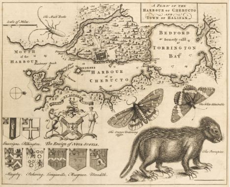

The Gentleman's Magazine, or Monthly Intelligencer, 158 volumes, a near unbroken run, volumes I-XLVIII, L-LXX, LXXII-LXXX, LXXXIII-LXXXVIII, CX-CIII, New Series, volumes I-III, V, VII-VIII, X, XVI, XXIII, XXV & XXXV-XXXVII, London: 1731-1852, lacking only volumes XLIX (1779), LXXI (1801), LXXXI-LXXXII (1811 & 1812), LXXXIX (July-December 1819), and New Series, volumes IV, VI, and IX (July-December 1835, July-December 1836, and January-June 1838), profusely illustrated with engraved plates and maps, including many folding, woodcut illustrations to text, almost all bound in contemporary half calf, the first twelve volumes rebound in good-quality antique-style modern uniform lighter brown half calf, spines gilt with morocco labels, occasional wear and a few covers detached (bindings generally in better than usual condition), one or two with later rebacks or repairs, together with four volumes only of The Gentleman's Magazine Library: being a classified collection of the chief contents of the Gentleman's Magazine from 1731 to 1868, edited by George Lawrence Gomme, English Topography, Parts IV, VI, X and XII only, 1893-1900, bound in original cloth, all 8vo QTY: (158)NOTE:Provenance: Many of the earlier volumes bear the early 19th-century bookplate of Toft Hall, Cheshire, the seat of Ralf Leycester (1763-1835), MP for Shaftesbury (1821-1830). The house contained a library which was added during the renovations made between 1810 and 1813 by the architect Samuel Pepys Cockerell. Several other volumes contain 19th-century bookplates from different owners.A near-complete run of the Gentleman's Magazine from its commencement in 1731 to the early 19th century, complete with the majority of the required maps and plates. Sold as a periodical, not subject to return.This impressive run contains many of the important maps and plans relating to the American Wars of Independence, and also includes one of the earliest reports of the Boston Tea Party (volume 44, 1774), and one of the earliest British printings of the Declaration of American Independence (volume 46, 1776). Engraved American maps present in this lot, as listed in David Jolly, Maps of America in Periodicals before 1800 are, according to his numbered listing: 3-10, 17, 26, 32-33, 36, 44, 45 (some fraying to left and right margins with slight loss to lower right edge), 46 (bound opposite page 123), 53-55, 65 (central horizontal closed tear without loss), 69-70, 82, 83 (slight offsetting), 118-122, 164-165, 186-190, 219-222, 242, 244 (bound facing page 513), 245, 247-248, 257, 258 (bound opposite page 264), 259-260, 286 (slight offsetting), 287, 290 (slight offsetting), 309, 319-321, 336, 357 (short closed tear at head), 409, and 427. Amongst these are: An Accurate Map of the West Indies (no. 3, 1740), New Map or Chart of the Western or Atlantic Ocean (no. 10, 1740), Plan of the Harbour of Chebucto and Town of Halifax (no. 36, 1750), Map of Philadelphia and Parts Adjacent (no. 45, 1753, with slight loss), Map of the British and French Settlements in North America (no. 54, 1755), Map of that Part of America which was the Principal Seat of War in 1756 (no. 69, 1757), Accurate Map of the British Empire in Nth. America as settled by the Preliminaries in 1762 (no. 190, 1762), Louisiana, Virginia, & Carolina (no. 220, 1763), Map of the New Governments of East & West Florida (no. 221, 1763), The British Governments in Nth. America laid down Agreeable to the Proclamation of Octr. 7, 1763 (no. 222, 1763), Map of Part of West Florida, from Pensacola to the Mouth of the Iberville River (no. 247, 1772), Plan of the Town and Chart of the Harbour of Boston (no. 257, 1775), Map of 100 Miles round Boston (no. 258, 1775), New and Correct Plan of the Town of Boston (no. 260, 1775), Map of Connecticut and Rhode Island (no. 290, 1776), Map of Philadelphia and Parts Adjacent (no. 309, 1777), Map of Hudson's River (no. 319, 1778), Map of the Island of Dominica (no. 320, 1778), Map of the Island of Tobago (no. 321, 1778), Plan of the Harbour of Omoa (no. 336, 1780), and Map Shewing the Communication of the Lakes and Rivers between Lake Superior and Slave Lake in North America (no. 427, 1790).The engraved maps not present are New Chart of the Coast of New England (no. 23, 1746), Map of the British American Plantations (no. 47, 1754), Map of the World on Mercator's Projection (no. 56, 1755), Physical Planisphere (no. 71, 1757), Map of the Country round Philadelphia (no. 288, 1776), Sketch of the Country Illustrating the Late Engagement in Long Island (no. 289, 1776), Map of the Progress of His Majesty's Armies in New York (no. 291, 1776), and Plan of St. Lucia in the West Indies (no. 328, 1779). Sold as a periodical, not subject to return.
We found 184 price guide item(s) matching your search
There are 184 lots that match your search criteria. Subscribe now to get instant access to the full price guide service.
Click here to subscribe- List
- Grid
-
184 item(s)/page
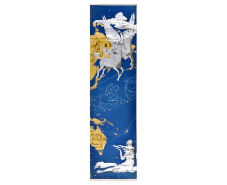
Rare original large size multi sheet vintage TWA Trans World Airlines planisphere route map poster, incomplete with only borders and one image sheet present. Amazing design featuring red bold lettering with the company name and white lettering with USA, Europe, Africa, Asia framed in golden ornaments, illustration of centaurs and pegasus, constellation of lion and cancer, set above the map of the world showing the Far East with hunters and a dog near huts, marking Tokyo on the map of Japan, and images of platypus, koala and aboriginal people on the outline of Australia, a lady in white directing a plane, all set over a blue background with stars. Trans World Airlines (TWA) was a major American airline from 1924 to 2001 when it was acquired by American Airlines. Fair condition, creasing, tears, staining, small paper losses, 11 sheets of incomplete poster. Country of issue: , designer: Unknown, size (cm): Trans world airlines panel - 38x166cm / USA Europe Asia Africa Panel - 38x166cm / Centaur Panel - 177x47cm, year of printing: 1950s, border panels: 38x92cm, 38x115cm, 38x113cm. Photo of complete poster provided for reference only.


![De Lafeuille [Daniel] Mape Monde Planisphere ou Carte Generale du Monde, Amsterdam: D. De Lafeuille, n.d. [1702], thirty engr](https://cdn.globalauctionplatform.com/574f0070-8868-408f-94c5-b1cc00fe1433/8e1657f8-cb00-4c67-b771-b1e200ca8e27/468x382.jpg)
De Lafeuille [Daniel] Mape Monde Planisphere ou Carte Generale du Monde, Amsterdam: D. De Lafeuille, n.d. [1702], thirty engraved plates and an additional engraved plate of L'architecture Militaire ou L'ecole de Mars et de Neptune, oblong folio, original marbled paper wrappersOmbersley Court, Wocestershire


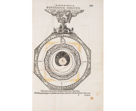
Schoener (Johann) Opera Mathematica, 3 parts in 1, first edition, collation: ?6, ?4, A-Z6, Aa-Cc6, Dd-Ee8, Ff-Mm6, Nn8; a-h6, i8, including errata, colophon and final blank leaf, but lacking 2 other blanks, Roman and Greek type, title printed in red and black with two large woodcut ornaments, woodcut printer's device at end, woodcut portrait of the author on ?4v, numerous woodcuts and diagrams, 4 full-page woodcuts, including terrestrial globe, celestial globe and planisphere, complete with eleven diagrams with working volvelles (although moveable parts supplied in later (?18th century) facsimile and thread renewed), woodcut initials, generally very fine, wide-margined copy, title gutter reinforced, quire R lightly browned, few other leaves toned, small wear to lower blank margin of b3v, tiny wormhole in blank outer margin of last several leaves, contemporary blind-tooled pigskin over wooden boards, covers within two blind-stamped rolls, outer roll dated 1541 and depicting the Crucifixion, David, the Resurrection, and St. John, inner roll dated 1556 and showing Lucretia, Caritas, and Justicia, later stamp of Schola Altenburgensis printed in gold in centre of upper cover and in black on lower cover, some minor abrasion to binding, spine slightly chipped at head, corners lightly rubbed, folio (306 x 201mm.), Nuremberg, J. Montanus & U. Neuber, 1551.*** Rare and important work with a most distinguished provenance, in excellent condition and in its strictly contemporary binding. The Honeyman copy of the first edition of the collected works by Johann Schöner, mathematician, astronomer, cartographer, and scientific instrument maker from Karlstadt, in Bavaria.Schöner was a contemporary of Nicolaus Copernicus and in 1526 he became the first professor of mathematics at the University of Nuremberg. His most illustrious pupil was Georg Joachim Rheticus, who in the Narratio prima (1540) announced Copernicus' discoveries. Schöner was also active as a printer and even set up a press in his house, printing numerous previously unpublished works by Johannes Regiomontanus, as well as the first printed terrestrial globe to name the recently discovered continent of America.The Opera mathematica was published posthumously by his son Andreas and is introduced by a preface by the outstanding humanist and reformer Philipp Melanchthon (1497-1560). The volume contains a representative sample of Schöner's wide and diverse interests, and a digest of some of his separately published works, most of which are extremely rare. Part 3 contains the most important section, which describes and illustrates eleven instruments, under the title Aequatorium Astronomicum, ex quo errantium stellarum motus, luminarium configurationes, & defectus colliguntur, a revised and enlarged version of the work which first appeared in 1521. The Aequatorium Astronomicum contains the earliest collection of printed equatoria-diagrams, as well as a catalogue of stars adapted by Schöner from that published by Copernicus in his De revolutionibus of 1543.The text is illustrated by an elaborate series of volvelles (movable wheel charts) used to determine planetary positions. Each part of these volvelles was printed on a separate page, such that the reader could cut them out or trace them on separate pieces of paper, and then assemble the various parts with string. These fragile 'paper instruments', which Schöner was among the first to employ, are frequently lacking or only partially present in most other copies of this work, and they are very often constructed incorrectly.Provenance: from the library of the Latin school in Altenburg, Germany (stamp on the binding 'Biblioth. Schol. Altenburgensis'); the English politician and book collector Sir Robert Leicester Harmsworth (1870-1937; his sale at Sotheby's London, 9 February 1953, lot 9605); Robert Honeyman IV (1897- 1987; see The Honeyman Collection of Scientific Books and Manuscripts. Volume vii. Printed Books S-Z and Addenda, Sotheby's New York, 19-20 May 1981, lot 2802A); Astronomy & Science Books from The Library of Martin C. Gutzwiller, lot 175.Literature: Adams S-678, 685; VD16 S-3465; Alden 551/35; BEA, pp. 1027-1028; Houzeau - Lancaster 2388; Sabin 77806


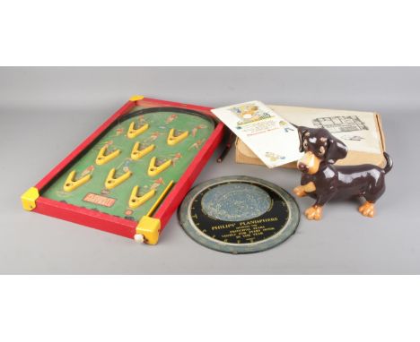
A Shelf of Ornamental Items, including a pair of Nuremberg Folk Art Candlesticks, pair of turned wood nut dishes and integral nutcrackers, a Philip's Planisphere, a Linseed Oil advertising paper clip, a Viners stainless steel Profile pattern part table service, a gilt easel back mirror, a poker work box, small oak casket etc.

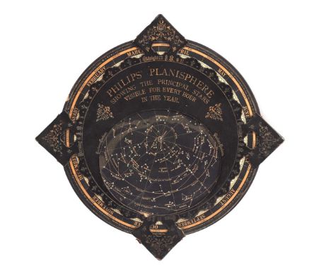
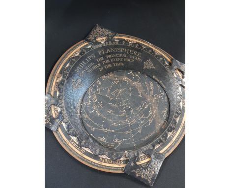
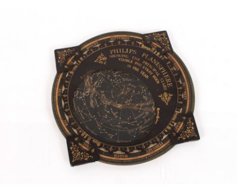
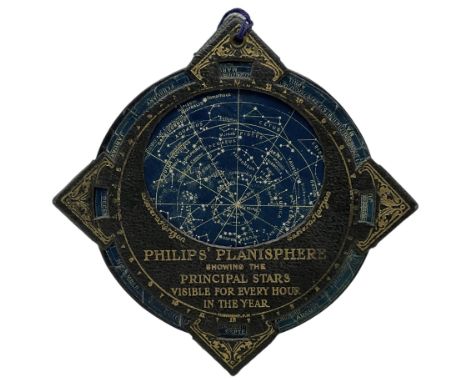
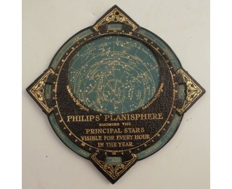
Planisphere. Philips' Planisphere showing the Principal Stars Visible for every Hour in the Year, circa 1890, celestial chart of the stars, printed in blue and white on paper-board, moveable and constrained within a gilt morocco disc with four compass points, printed explanation on the verso, slight wear to the extremities, 315 x 315 mmQTY: (1)
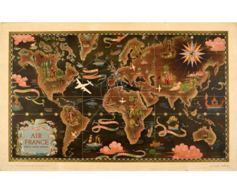
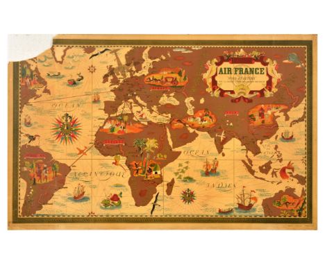
Original vintage planisphere travel route map poster promoting Air France Reseau Aerien Mondial the global air network of the French national airline carrier. Design by Lucien Boucher (1889-1971) featuring an illustrated planisphere map of the world with route lines and planes in white showing the airline's services to various international destinations including colourful images of famous landmarks, people, animals and ships at sea with the title text in bottom left within a decorative border and clouds, banners and the Air France seahorse (pegasus / hippocampe aile) logo inside a compass point at the top right. Lucien Boucher produced maps and planisphere designs for Air France from 1933; his artwork for the airline is considered an embodiment of the golden age of air travel. Horizontal. Good condition, staining, restored tears, restored paper losses, rough trimmed edges, paper skimming on margins, backed on linen. Country of issue: France, designer: Lucien Boucher, size (cm): 57x91, year of printing: 1947.
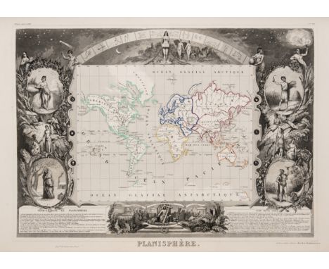
World.- Levasseur (Victor) Atlas National Illustre des 86 Departements et des Possessions de la France Divise par Arrondissements, Cantons et Communes..., engraved title page, 100 engraved maps, including individual French departments and French colonial possessions of the time, with a double-page map at the back of the atlas showing France as a whole, the 'Planisphere' map still showing Texas as independent, all with decorative vignettes and illustrations in the margins, some outline hand-colouring, some occasional minor spotting and browning, contemporary half calf with marbled boards, scuffs and some rubbing, folio, 1852.


![ROSSI, Giacomo Giovanni de. [Mercurio Geografico overo guida geografica in tutte le parti del mondo ...], Planisphere of the](https://cdn.globalauctionplatform.com/120806ca-fe91-4ac9-9fe8-b05400fa9d68/98a7fd23-667d-4088-b1ee-b0c0011d5948/468x382.jpg)
ROSSI, Giacomo Giovanni de. [Mercurio Geografico overo guida geografica in tutte le parti del mondo ...], Planisphere of the Celestial Globe Arctic and Antarctic, copper engraved with text to tail, tear with loss to bottom left, centre fold, some light spotting to margins, framed, mounted and glazed, published by Giovanni Giacomo de Rossi. Vin Mariotti, Sculp. Roma, [1687]. (43cm x 57cm)

An important and very rare late 18th century Dutch brass-mounted mahogany musical table clock with calendar, Dutch strike, planisphere dial and moonphaseRutgerus van MeursThe inverted bell top case surmounted by five facetted urn and acorn finials, with brass banding between, the canted angles set with boldly cast floral and berry mounts, side handles and elaborate pierced and engraved brass sound side frets, on a base with curled winged feet.The 8 inch arched brass dial set with interlaced white enamel Roman and Arabic chapter rings, framed by small cast brass floral scrolls, the centre finely matted and engraved; a day of the week deity aperture above VI, a chamfered calendar aperture below XII, above the signature Rútgerús van Meúrs Amsterdam; framed by four subsidiary dials for Year 1-4 cycle, music selection (offering 8 tunes), play/not play and strike/not strike with elaborately pierced blued steel hands, a silvered astrological indicator and painted moonphase in the arch.The substantial twin chain fusee movement with verge escapement, the plates united by eight knopped pillars, seven latched, the backplate with exterior fly, engraved Rutgerus Van Meurs Amsterdam, the 8 inch long pinned cylinder playing tunes on 18 bells and 25 hammers. Ticking. With a winding key and two case keys. 41cm wide x 29cm deep x 75cm high, (16in wide x 11in deep x 29 1/2in high)Footnotes:ProvenanceHans Kreft, Neerpelt, 1985.Rutgerus van Meurs was born in Amsterdam in 1736 to Otto van Meurs and Elisabeth Potgieter. His father was also a horologist, and it is likely that Rutgerus was apprenticed to him. His workshop was in the Utrechtsestraat 143 and at some point he married Elisabeth Moret. Like his father, he made watches and longcase clocks, but Rutgerus was also one of the few Dutch horologists to make astronomical clocks, for which he is best remembered today. (See Amsterdam Horology (2020) Rutgerus van Meurs. Available at: https://www.amsterdamshorloge.nl/rutgerus-van-meurs.html)This lot is subject to the following lot symbols: ** VAT on imported items at a preferential rate of 5% on Hammer Price and the prevailing rate on Buyer's Premium.For further information on this lot please visit Bonhams.com


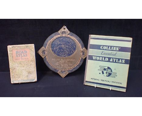
Set of Edwardian brass postal scales on an oak base, with 4 brass weights, W.30cm overall; set of apothecary's scales with weights in a mahogany case, W.17.3cm; brass lantern timepiece with a French movement, H.23cm; Kienzle timepiece, travelling timepiece and hygrometer, 2 part sets of drawing instruments, brass pen tray, Q Ray electro-radioactive dry compress, Phillips' Planisphere, Dia.25.8cm; 2 rolling rules, and other items. (a lot)

A Collection of 19th century and later Collectables, including various Tartanware and Tortoiseshell boxes, a Tunbridge stamp box, a 1930's perpetual desk calender, a silouette miniature with gilt hightlights and a Philips planisphere, etc (one tray)Maughlin wear, Malcolm Tartan box, painted with cauldron iron, with a large chip to the centre of the picture, Lorn Tartan, with a repaired knop and numerous chips to the foot, snuff box with numerous scratches, Tortoiseshell box with chips to the corners and a loose hinge, feet also lacking, Philip' planisphere, with noticable wear, painted stamp box holder, with heavy wear to the painted surface, Tunbridge stamp box, with multiple scratches to the top, rowing boat enamel plaque with chips, remaining items in reasonable condition

Vintage Philips' Planisphere, 26cm diameter, together with antique Marine/Field/Theatre binoculars, with toggle adjusting lenses, central bar inscribed MARINE/THEATRE/FIELD, in leather case, a Surveyors' cross by Stanley, Great Turnstile, Holborn, London, with integral handle, 8.5cm long, in box, and a Knotmaster MKIIIA ship's log by Thomas Walker & Son Ltd, Birmingham, within fitted pine case (4) Surveyors' cross by Stanley, Great Turnstile, Holborn, London, with integral handle, 8.5cm long, in box

"PLANISPHERE CELESTE" - kleinformatiger Kupferstich der Tierkreiszeichen, handkoloriert. Kupferstich von P. de la Hire, gedruckt bei N. de Fer, Paris, 1702, gestochen von H. van Loon. Keine Mittelfalz erkennbar, fachmännisch in Passepartout hinter Glas gerahmt. Platte ca. 23 x 33 cm, Rahmen beigegeben, max. Außenmaß ca. 39 x 49 cm. Schöner Erhalt, leichte Bräunungen.
Original vintage travel poster Air France Nova et Vetera Sur La Vieille Terre des Chemins Noveaux / On the old earth of new paths, featuring design by Lucien Boucher (1889-1971) depicting an illustrated planisphere map of the world with route lines and planes in white showing the airline's services to various international destinations with illustrations of people in various parts of the world. Printed by Perceval, Paris. Good condition, foxing, creasing, staining, tears, pinholes, large paper loss in top left corner. Country of issue: France, designer: Lucien Boucher, size (cm): 63x99, year of printing: 1930s.

Thirteen items to include - Three watercolours: Robert Lawrence - Coastal Scene; Bryn Miles - Country Landscape; and Chinese watercolour of three birds; Cunard Queen Elizabeth 2 poster signed by passengers; four signed prints: Martin Ridley- Kingfisher and Salmon; Moy Mackay - 'Poppy Shore'; Suzan - 'Seagulls Soaring (44/200); and one other; together with two other framed prints and Philip's Planisphere astronomy calendar, largest: 76 x 56 cm (12)

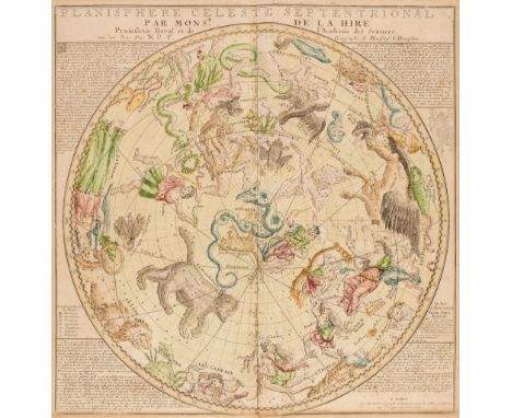
Celestial Maps. De Fer (Nicolas), Planisphere Celeste Septentrional par Monsr. De La Hire..., mis au jour par N. D. F. Geographe de Monseigr. le Dauphin, Louis Charles Desnos, Paris, circa 1770, hand-coloured celestial chart of the northern hemisphere, engraved by Hendrick van Loon, slight spotting, toned in the margins, some creasing, 470 x 465 mm, together with Dunn (Samuel). The Principal Fixed Stars of the North Hemisphere Delineated on the Plan of the Equator for the Year 1774 [and] The Principal Fixed Stars of the South Hemisphere Delineated on the Plan of the Equator for the Year 1774, Robert Sayer, 10th June 1786, two uncoloured engraved celestial maps, very slight spotting to the margins, each approximately 365 x 550 mm, with Doppelmayr (Johann Gabriel). Untitled celestial chart, circa 1742, hand-coloured celestial chart, central fold partially split with some old tape staining, toned and dust soiled overall, slight worming in the margins, 350 x 365 mm, plus two late 18th century engravings of globes and orrerys, various sizes and conditionQTY: (6)NOTE:The first described item was first published in 1710 along with a companion print of the constellations of the Southern Hemisphere by Nicholas de Fer. The maps were reissued by de Fer’s son-in-law, Guillaume Danet, and a later edition was issued under the imprint of the renowned French cartographer and publisher of maps and globes, Louis-Charles Desnos; the example offered here.


Astronomie - - Sigismund Visconti. Tableaux du systeme planetaire par Sigismond Visconti et. Adolphe Auguste Dufour. Mit 7 farbig in Punktierstich gestochenen Karten. (Paris: Charles Simonneau, 1830). 12° u. Folio. Hldr. mit gold RTitel u. Hldr. d. Zt. mit goldenen RTitel und blauem Deckelschild (etwas berieben). Houzeau & Lancaster 8172 (Nur der Textband). - Prachtvoller und seltener Atlasband mit dem meist fehlenden Textband. - Die eindrucksvollen 7 wunderschönen doppelseitigen Farbtafeln, die von A. Gianni nach den Zeichnungen von Sigismond Visconti für die ersten 5, von Visconti überarbeitet von Auguste-Henri Dufour für die 6 und von Dufour für die letzte Seite gestochen wurden, zeigen das Sonnensystem, den Orbit der jährlichen Umdrehung der Erde um die Sonne mit Angabe der Jahreszeiten, die Phasen des Mondes, die Eklipsen der Sonne und des Mondesm Fluss und der Rückfluss. Querschnitt durch die Erde, aufgenommen am Äquator und von der Seite des Arktischen Pols aus gesehen. - sowie die Planisphäre. Minimal vor allem an Rand seltener fleckig, wenige Knickspuren. Insgesamt gutes Exemplar in kraftvollen farbigen Abzügen. Selten. Astronomy. - Splendid and rare atlas volume with the text volume mostly missing. - The impressive 7 beautiful double-page color plates engraved by A. Gianni from the drawings of Sigismond Visconti for the first 5, Visconti revised by Auguste-Henri Dufour for the 6 and by Dufour for the last page, show the solar system, the orbit of the annual revolution of the Earth around the Sun with indication of the seasons, the phases of the Moon, the eclipses of the Sun and the Moonm flow and reflux. Cross section of the Earth taken at the equator and seen from the side of the Arctic Pole. - and the planisphere. Minimally spotted especially at margins rare, few traces of creases. Overall good copy in powerful colorful prints. Rare.
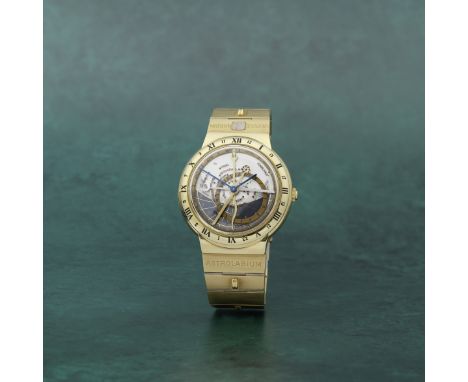
Ulysse Nardin. A fine 18K gold automatic astronomical bracelet watchModel: Astrolabium Galileo GalileiReference: 911-22Date: Circa 1990Movement: Jewelled Cal.91.7.151 automatic, 18K gold rotorDial: Two plate dial consisting of a silvered three tone fixed planisphere of celestial co-ordinates, beneath a rotating transparent rete labelled with the position of numerous bright stars with the ecliptic shown in gold all within a gold annual calendar ring, together representing the annual path of the Sun (Zodiac) against the background stars, gilt Solar hand marking the annual change of meridian height of the Sun, silvered Lunar hand indicating age and aspect of the Moon, Dragon hand predicting eclipses, luminous hour and minute handsCase: Polished round, exhibition back secured by 4 screws, Roman and Arabic numeral 24 hour markers to bezel, No.151Strap/Bracelet: Integral brushed link with alternating ridgesBuckle/Clasp: Signed folding claspSigned: Dial & movementSize: 40mm Accompaniments: Winding box, Ulysse Nardin service case, Swisstec repair warranty card dated June 2022Footnotes:The notion of 24 hours a day was derived through astronomical observations. To pay homage to the three brilliant names in the world of astronomy: Galileo Galilei, Copernicus, and Johannes Kepler, Ulysse Nardin launched a series of three timepieces in collaboration with the genius watchmaker Ludwig Oechslin in 1985, 1988, and 1992. The series is widely known by the enthusiasts as the 'Trilogy of Time'. The present watch is an example of Astrolabium Galileo Galilei, which was the first of the trilogy. The dial indicates the position of the Sun, the Moon and the stars as seen from the earth. In addition, the watch also tells sunrise and sunset, moon phases, moonrise and moonset as well as eclipses of sun and moon. Not only does this watch present the most unique and complicated way of telling time, it also exemplifies the brand's commitments to engineering and watchmaking.The origin of the astrolabe is lost in antiquity, but it was possibly a Greek invention of the 2nd century BC. It was developed by Persian and Arabic astronomers and was widely used by the 9th century AD. The oldest surviving instruments date from the Middle Ages and were made throughout the Renaissance in Europe. The astrolabe remained an important tool of Islamic astronomy well into the 19th century.For further information on this lot please visit Bonhams.com

World.- Northern hemisphere.- Van der Aa (Pieter) Planisphere Terrestre, Suivant les nouvelles Observations des Astronomes, map of the World based on Cassini's important north polar projection, with Greenland attached to mainland North America and California as an island, with much of the Pacific Northwest left blank, with border decorations of the four elements engraved by by G. Van Gouwen, engraving on thick laid paper, sheet 553 x 760 mm (21 3/4 x 29 7/8 in), mounted on conservation support, central vertical fold with repairs to old splits and associated losses, section of loss to lower left margin restored, not affecting the map, some browning and surface dirt, unframed, Leiden, 1713.
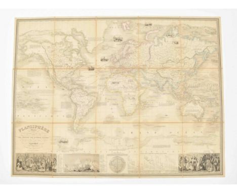
présentant la description géographique des parties connues de la Terre (...) les colonies des diverses nations (...) dressé par Vuillemin. Gravé par Langevin. Paris, Fatout, 1851. Total 83 x 109 cm. Mounted on linen in 15 segments.The world map in Mercator projection, partly col. 3 ills. and "tableau explicatif" at the bottom, a few sm. ills. in vignettes and explanatory texts on map image. Loose as issued in orig. folder (29 x 23 cm) w. dam. spine and titled "Planisphere".


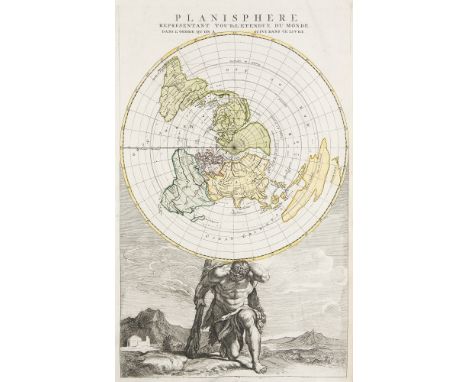
Weltkarte - - Planisphere representant toute l'etendue du monde ... Teilkol. Kupferstichkarte von Jan Barend Elwe. Um 1792. Plattenmaße ca. 43,5 x 27,5 cm, Böattmaße ca. 55 x 32 cm. Zeigt die von Atlas getragene Welt mit Karte der Nordhalbkugel. - Linker Blattrand hinterlegt, wenig knitterig, insgesamt wohlerhalten. Part coloured copper engraved map by Jan Barend Elwe. - Showing the world carried by atlas with map of the northern hemisphere. - Left margin backed, a little creased, overall in good condition.


World. Porcacchi (Tomaso). Descrittione de Mappamondo, Girolamo Porro, Venice, circa 1620, uncoloured engraved map of the world on a pseudo-cylindrical projection (popularised by Ortelius in his 1564 map of the world), map size 110 x 145 mm, Italian text below and on the verso of the map, together with Bonne (Rigobert). Planisphere Suivant la Projection de Mercator, circa 1780, uncoloured engraved map, 225 x 325 mm, with Moll (Herman). The World in Planisphere, circa 1701, hand-coloured engraved map on a hemispherical projection with an additional hemisphere of the North Pole, additional title above the map, map size 165 x 190 mm, English text on verso, plus Guthrie (William). The World from the best Authorities, circa 1790, uncoloured engraved map on a hemispherical projection, old folds, slight staining, 200 x 390 mm, and Wyld (James). Orbis Veteribus Notus, 1825, engraved miniature historical map with contemporary outline colouring, slight dust and finger soiling, 110 x 130 mm, with a mid-19th-century Japanese colour woodblock map of the world on a hemispherical projection, 240 x 310 mmQTY: (6)

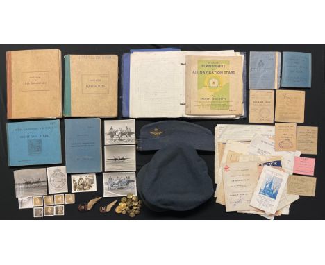
WW2 British RAF Navigators Group to 164849 Flying Officer Stanley Charles Masterson comprising of: Navigator's, Air Bomber's & Air Gunners Flying Log Book commencing 9/9/1943 to 17/10/1944, 111 hours day and 43 hours night. Aircraft include Oxfords, Ansons and Mosquitos. : RCAF Sight Log Book Jan 1944 to April 1944: Officer's Validity Card: RAF Flying Clothing Card listing kit issued: RAF Service & release Book: RAF Officers Service Dress Cap, Canadian made by Wm. Scully of Montreal complete Officers cap badge, chinstrap and with the original 1944 sales receipt: Officers Field Service Cap complete with badge: training logs, RCAF buttons, British made Navigators Brevette, plus a padded Canadian made Navigators Brevette with price label still affixed to reverse: Paybook, documents, photos, notebooks from training, telegrams, Planisphere of Air Navigation Star, etc. F/Lt. Masterson rose through the ranks from an Airman. Did his aircrew training in Canada. Saw early post war service in Italy. New to the market.
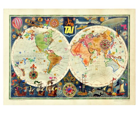
Original vintage travel advertising poster for TAI Transports Aeriens Intercontinentaux Map of the World by Luc-Marie Bayle (1914-2000) featuring a colourful planisphere map showing the airline's routes around the globe surrounded by fun images of explorers in different modes of transport from hot air balloons and an early Wright flyer to a modern TAI plane and rowing boats to a paddle steamer and sailing ships with fish and birds on both sides of a decorative compass point below, the bold yellow TAI coat of arms title text between the stars in the night sky above. In 1963, TAI merged with Union Aeromaritime de Transport to form UTA French Airlines (merged into Air France in 1992). Horizontal. Good condition, creasing, tears, staining. Country of issue: France, designer: Luc Marie Bayle, size (cm): 58x80, year of printing: 1950s.

IMHOF ORE DEL MONDO, ANNI '50 Cassa: firmata, n. 71 576, in ottone. Quadrante: firmato, fascia oraria argentata, indici applicati, fascia oraria a 24 ore e satellite centrale con il planisfero diviso per le corrispettive 24 città del mondo. Movimento: firmato, cal. manuale 544, n. 1284008, scappamento ad ancora, bilanciere monometallico, spirale piana. Accessori: – Misure: 12 x 11 x 6,5 cm Note: funzionante, ma da revisionare. IMHOF WORLD TIME, 50S Case: signed, n. 71 576, in brass. Dial: signed, silvered hour ring, applied indexes, 24-hour disc and centered satellite with the planisphere divided in the corresponding 24 cities of the world. Movement: signed, manual-winding cal. 544, n. 1284008, lever escapement, monometallic balance, flat hairspring. Accessories: – Size: 12 x 11 x 6,5 cm Note: working, but to be serviced.


-
184 item(s)/page