We found 214876 price guide item(s) matching your search
There are 214876 lots that match your search criteria. Subscribe now to get instant access to the full price guide service.
Click here to subscribe- List
- Grid
-
214876 item(s)/page

Lot 366
Toys & Juvenalia - Corgi diecast models, comprising Corgi Junior 15 School Bus, on header card; Corgi 1:50 scale Collection Heritage EX74005 Citroen C55 Plateau avec Bouteilles - Air Liquide, boxed; Corgi Texaco, The Texas Company showcase display series #1 CS90003 Pontiac van, Texaco Fire Chief Gasoline, window boxed; other Corgi models (quantity)

Lot 337
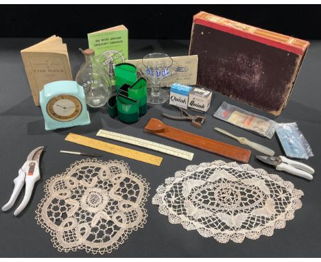
A clear glass rummer type goblet, RAF interest, commemorative of the Avro Lancaster, enamelled in blue, 15cm; a 1980s Italian Running Horse desk tidy; WWII blotting paper; a scale rule; a Smith's Bakelite electric mantel clock; a booklet about The Eyam Plague; a Radio operator's handbook; a Haig's bottle; etc
Lot 22
The Italian Job A superb piece of Cinematic History . Imagine planning how and when to create iconic car chases and stunts. This is a piece of that history. After which the scene was set. The vendor recalls `My father - RALPH COOPER - was the freelance publicist on the original filming of The Italian Job in 1967/68 with Michael Caine as the main actor.The poster emanates from that time and was by the production designer for Paramount Services, Disley Jones. In a scale of 1:100, it shows the details of the ramp and scenery of the Fiat roof in Milan across which the three Mini Cooper cars jumped whilst being chased by Italian Police in an iconic scene in the film` Whilst the item whcih has been backed and preserved is faded it is a rare survivor. It measures approx 37 inches by 54 inches with linen backing.
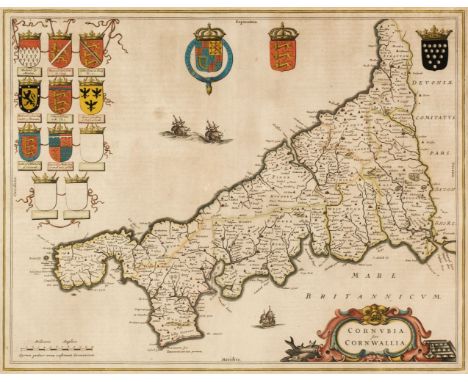
Lot 37
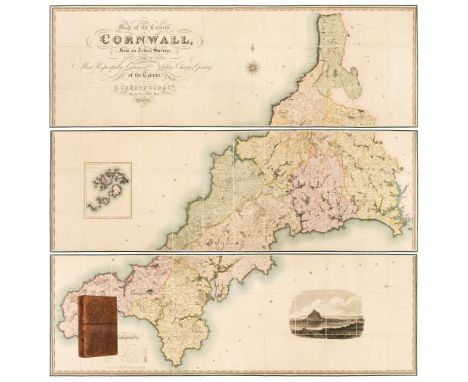
Cornwall. Greenwood (C. & J.), Map of the County of Cornwall from an Actual Survey, made in the Years 1826 & 1827, by C. & J. Greenwood. Most Respectfully Dedicated to the Nobility, Clergy & Gentry of the County, published Greenwood & Co. 1827, large scale engraved map on three sheets, sectionalised and laid on linen, bright contemporary wash colouring, inset map of the Scilly Isles, calligraphic cartouche, engraved vignette of St. Michaels Mount, table of explanation and compass rose, faint offsetting, each sheet approximately 605 x 1845 mm, each sheet edged in green silk, marbled endpapers, contained in a contemporary tree calf book box with a contrasting red morocco gilt label to the spineQTY: (1)NOTE:R. C. E. Quixley (2nd edition expanded by J. M. E. Quixley). Antique Maps of Cornwall and the Isles of Scilly, number 76. A fine copy in very good condition.
Lot 77
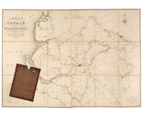
Johnson (William and Son). A Map of Several Canals situated in the Counties of Lancaster, Derby, York & Chester; Shewing the Heights of their pools above the Level of the Sea at Low Water...., 1825, map with contemporary outline colouring, engraved by J. & G. J. Pickett, sectionalised and laid on linen, calligraphic title, compass rose, mileage scale and table of reference, slight ink staining, 865 x 1240 mm, marbled endpapers, contained in a contemporary marbled card slipcase, case worn and rubbedQTY: (1)
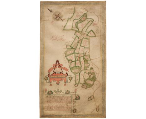
Lot 53
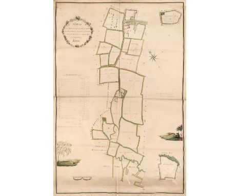
Estate Plan. Sparrow (Joseph), A Map of an Estate belonging to Mr. J. Dunk, also Stock Farm situated in the Parishes of Smeeth, Brabourn & Aldington in the County of Kent, 1803, pen, ink and watercolour plan on vellum, floriate cartouche, compass rose, contents list and scale of rods and chains, two inset maps of adjacent fields, two watercolour vignettes, one of a pastoral scene with cattle and sheep, the other of a running hare, old folds, some dust soiling, faint later pencil annotations, 910 x 630 mmQTY: (1)
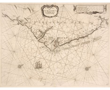
Lot 70
Ireland. Lootsman (Jacob), De Zuyd Oost Zyde van Yerlandt van Dubling tot aen t'Eylandt Corkbeg, circa 1668, uncoloured engraved chart of the southeast coast of Ireland from Dublin to Cork, ornamental strapwork title and distance scale, numerous rhumb lines, compass rose and ships, one closed tear professionally repaired at the base of the central fold, 415 x 545 mmQTY: (1)
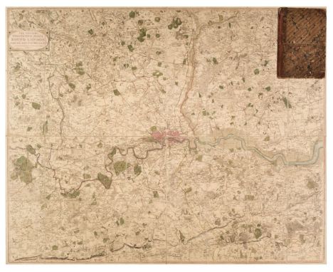
Lot 87
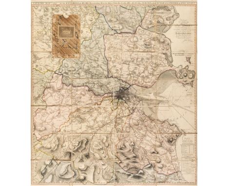
London. Faden (William), The Country Twenty-Five Miles Round London Planned from a Scale of One Mile to an Inch..., 3rd. edition, 1815, engraved map with contemporary outline colouring, sectionalised and laid on linen, 1015 x 1270 mm, contained in a contemporary half sheep book box, heavily worn and frayed, small area of loss to the foredge of the book boxQTY: (1)NOTE:James Howgego. The Printed Maps of London, number 188, state 7.
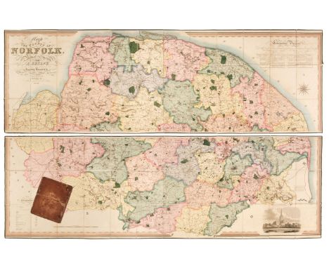
Lot 101
Norfolk. Bryant (Andrew), Map of the County of Norfolk from Actual Survey by A. Bryant in the Years 1824, 1825 and 1826, Respectfully dedicated to the Nobility, Clergy & Gentry of the County, published A. Bryant, Dec. 1st. 1826, large-scale engraved folding map on two sheets, bright contemporary hand colouring, sectionalised and laid on linen, calligraphic cartouche, list of the ecclesiastical divisions, compass rose, table of explanation and uncoloured engraved vignette of Norwich Cathedral, slight offsetting, bordered with green silk, each sheet approximately 750 x 2275 mm, contained in a contemporary sheep book box, box heavily worn and frayed with one section near detachedQTY: (1)NOTE:T. Chubb. A Descriptive List of the Printed Maps of Norfolk 1574 - 1916, page 106.
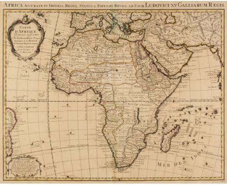
Lot 2
Africa. Covens (J. & Mortier P.), Carte D'Afrique Dressée pour l'Usage du Roy, par Guillaume DeLisle..., Amsterdam, circa 1730, engraved map with contemporary outline colouring, strap work cartouche and advertisement, title repeated in Latin in the upper margin, 510 x 635 mm, together with DeLisle (Guillaume). Carte D'Afrique Dressée pour l'usgae du Roy, par Guillaume DeLisle.., published by Phillipe Buache, Paris, circa 1745, engraved map with contemporary outline colouring, strap work cartouche and advertisement (a slightly later impression of the Covens & Mortier map), 505 x 650 mm, with Blaeu (Willem Janszoon), Aethiopia Inferior vel Exterior..., circa 1645, engraved map of South Africa with contemporary outline colouring, large decorative cartouche and mileage scale, large margins, 385 x 505 mm, no text on verso, plus Ortelius (Abraham). Barbariae et Biledulgerid Nova Descriptio, [1580], uncoloured engraved map, 330 x 500 mm, German text on verso, with another copy similar (1572 edition) with French text on the verso, with another four maps of Africa and South Africa including examples by or after Rapin/Tallis, le Rouge, Tardieu and Fullarton, and De Bruyn (Cornelius). Tyrus [1698 - 1714], uncoloured engraved panorama, taken from the sea, old folds, small near-contemporary manuscript notation in the upper margin, 250 x 640 mm and Scherer (Heinrich). Aethiopum Abassinorum Mores et Consuetudines, Munich [1702 - 10], uncoloured engraved decorative title page, 245 x 195 mmQTY: (11)
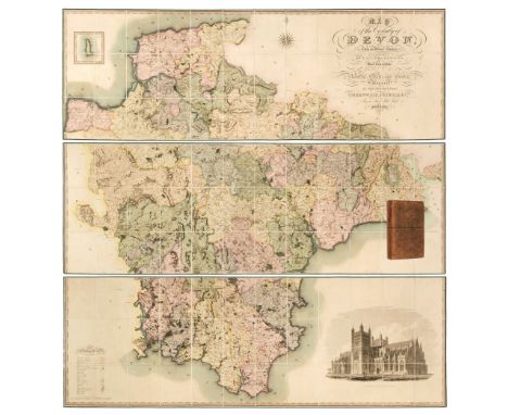
Lot 40
Devon. Greenwood (C. & J.), Map of the County of Devon from an Actual Survey, made in the Years 1825 & 1826 by C. & J. Greenwood, most Respectfully dedicated to the Nobility, Clergy and Gentry of the County, by the Proprietors Greenwood, Pringle and Co., February 20th, 1827, large scale engraved map on three sheets, sectionalised and laid on linen with bright contemporary wash colouring, inset map of Lundy Island, calligraphic cartouche, compass rose, table of explanation, uncoloured engraved vignette of the 'North West View of Exeter Cathedral', slight offsetting and spotting, each sheet edged in green silk, each sheet approximately 645 x 1905 mm, contained in a contemporary tree calf book box with a contrasting red morocco gilt label to spineQTY: (1)NOTE:Batten & Bennett. The Printed Maps of Devon, number 96.
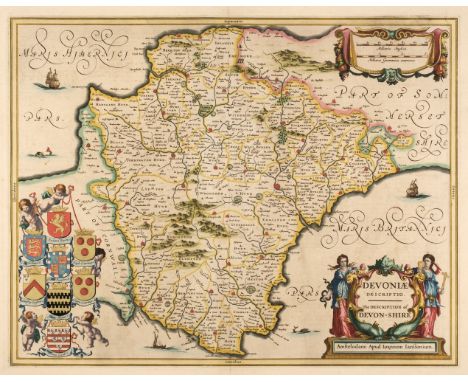
Lot 41
Devon. Jansson (Jan), Devoniae Descriptio. The Description of Devon-Shire, Amsterdam, circa 1646, engraved map with bright contemporary outline colouring, large decorative cartouche and mileage scale, large margins, slight spotting, 385 x 495 mm, French text on versoQTY: (1)NOTE:Batten & Bennett, The Printed Maps of Devon, number 11.
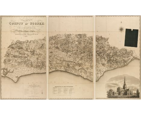
Lot 115
Sussex. Greenwood (C. & J.), Map of the County of Sussex from an actual Survey made in the Years 1823 & 1824..., Greenwood Pringle & Co., March 24th, 1825, large scale uncoloured engraved map, sectionalised and laid on linen, in three sections, calligraphic title, engraved vignette of Chichester Cathedral and table of reference to the hundreds, slight staining, 1250 x 2020 mm, marbled endpapers, contained in contemporary cloth slipcaseQTY: (1)
Lot 75
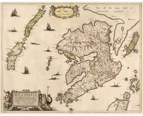
* Isle of Mull. Blaeu (W. J & Pont T.), Mula Insula quae es Aebudarum numero una est et Lochabriae ad occasum praetenditur. The Yle of Mull which is one of the Western Yles and lyeth ovir against Lochabÿr, Amsterdam, circa 1654, engraved map with contemporary outline colouring heightened in gilt, decorative title cartouche and mileage scale, 425 x 540 mm, mounted, framed and double-glazed, Latin text on verso QTY: (1)
Lot 73
Ireland. Taylor (John), Taylor's Map of the Environs of Dublin, extending 10 to 14 Miles from the Castle, by Actual Survey on a Scale of 2 Inches to 1 Mile, Dublin, 1816, engraved map with contemporary wash colouring, sectionalised and laid on linen, table of explanation, dedication and a note of the banks in Dublin Bay, 900 x 805 mm, contained in a contemporary marbled card slipcase, case worn and frayedQTY: (1)
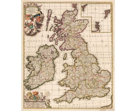
![British Isles. Ortelius (Abraham), Angliae, Scotiae et Hiberniae sive Britannicar: Insularum Descriptio [1610 - 12], engraved](https://cdn.globalauctionplatform.com/910db78b-cd1e-4760-a5d0-b0dc011def41/93275106-35f3-4e1c-bceb-b11e011ddb36/468x382.jpg)
Lot 30
British Isles. Ortelius (Abraham), Angliae, Scotiae et Hiberniae sive Britannicar: Insularum Descriptio [1610 - 12], engraved map with contemporary hand colouring and some later enhancement, orientated to the east, large strapwork cartouche and a panel of descriptive text, occasional repaired marginal closed tears, some oxidisation causing cracking and splitting, repaired on verso, the whole backed with archival tissue, 345 x 500 mm, Italian text on verso, together with Ortelius (Abraham & Lhuyd Humphrey). Angliae Regni florentissimi nova descriptio auctore Humfredo Lhuyd Denbygiense, [1580], hand-coloured engraved map, large strapwork cartouche and mileage scale, some cracking and splitting affecting the printed surface, repaired on verso, 375 x 470 mm, German text on versoQTY: (2)NOTE:The first described item: Marcel van den Broecke, Ortelius Atlas Maps, number 16. R. W. Shirley, Early Printed Maps of the British Isles 1477 - 1650, number 86.The second item: Marcel Van den Broecke, Ortelius Atlas Maps no.19. State 1 with the uncorrected mileage scale. R.W.Tooley, Early Printed Maps of the British Isles 1477 - 1650, number 109.
Lot 50
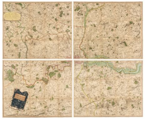
Environs of London. Faden (William), The Country Twenty-Five Miles Round London planned from a scale of one mile to an Inch, 3rd edition, 1802, engraved map on four sheets, contemporary outline colouring, sectionalised and laid on linen, each sheet approximately 515 x 620 mm, printed publisher's labels to the verso of each sheet, contained within a waxed card chemise and a contemporary blue card slipcase with printed label to the upper cover, slipcase worn and frayed, together with Mogg (Edward). Mogg's Twenty-Four Miles round London, 1812, circular engraved map with contemporary wash colouring, sectionalised and laid on linen, some staining and offsetting, small holes where old folds cross, 610 x 555 mm, some later pencil and ink annotations to the verso, contained in a contemporary card slipcase with orange and black publisher's label to the upper cover, slipcase heavily worn and frayed, with Andrews (John & Dury Andrew). A New Travelling Map of the Country round London, Extending from North to South 190 Miles and East to West 150 Miles..., September 30th, 1776, large scale engraved map with contemporary outline colouring, slight dust soiling, split and separated along an old fold, crude tape repairs to verso, 1010 x 1250 mm, contained in a modern marbled card slipcase with old publisher's label to the upper cover, plus another four later folding maps of the environs of London, including examples by or after Gall & Inglis and G. W. Bacon, various sizes and condition QTY: (7)NOTE:The first item described. J. Howgego, The Printed Maps of London, number 188, state 6.
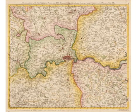
Lot 84
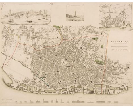
Liverpool. Starling (T.). Liverpool, published under the Superintendence of the Society for the Diffusion of Useful Knowledge, circa 1830, engraved map with contemporary outline colouring, 310 x 385 mm, together with Davies (B. R.), Liverpool and its Environs including the Cheshire Coast, circa 1830, engraved map after a survey by H. Austen, contemporary outline colouring, sectionalised and laid on linen, slight staining, some surface abrasion with loss, 445 x 530 mm, bound in contemporary cloth boards with gilt title to the upper cover, re-backed, size of boards 100 x 150 mm, with Philip (George & Son). Philips' Plan of the Town & Port of Liverpool with Birkenhead and the adjoining Cheshire Coast, circa 1860, engraved map with contemporary outline colouring, sectionalised and laid on linen, some later ink annotations, slight toning and dust soiling, 625 x 715 mm, bound in contemporary cloth boards with gilt title to the upper cover, size of boards 170 x 135 mm, plus Ordnance Survey (publishers). Untitled map of Liverpool and its environs, on a scale of six inches to a mile, 22nd September 1851, uncoloured engraved map, sectionalised and laid on linen, slight staining, 620 x 930 mm, contemporary cloth boards, upper board detached, spine crudely repaired, size of boards 225 x 145 mmQTY: (4)
Lot 52
Estate Plan. Boycot (Thomas). A mapp and Description of the mannor of hampton Liinge in the parish of braborne In Kent: with: 31: parcells of arrable and Pasture:; and: 12: Parcells of wood containing: 320: acrers noc Quarters:: 38: Peartches The: 31 Parcells of arrable and Pasture Contayne: 253: - 2 - 36: pertches: and the: 12 Parcells of wood Containe: 66 - 2 - D perchs, 1650, pen, ink and watercolour plan on vellum, compass rose, decorative distance scale surmounted by dividers, some dust soiling and creasing, 690 x 390 mmQTY: (1)NOTE:An unusually well-preserved mid-17th-century estate plan in the vicinity of Braborune, south-east Kent.This lot is subject to the Manorial Documents Rules 1959, 1963 and 1967, administered by The Historical Manuscripts Commission at The National Archives on behalf of the Master of the Rolls. Accordingly the purchasers of the documents lie under an obligation to notify the Secretary of the Commission of their acquisition and to provide details of where they will be kept. They may in no circumstances be removed from England and Wales without the prior consent of the Master of the Rolls.
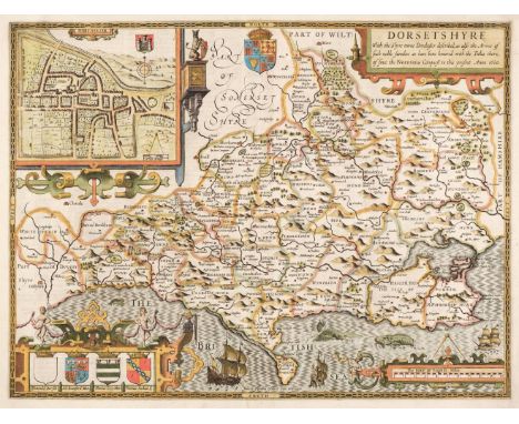
Lot 43
Dorset. Speed (John), Dorsetshyre with the Shyre-towne Dorchester described, as also the Armes of such noble families as have bene honored with the Titles there of since the Normans Conquest to this present, 1st edition, [1611], hand coloured engraved map, inset town plan of Dorchester, large strapwork cartouche and mileage scale, good margins, central fold strengthened on verso, unobtrusive blind stamp to the upper right corner, 385 x 510 mm, English text on versoQTY: (1)
Lot 49
Environs of London. A collection of ten maps, 18th and 19th century, engraved and lithographic maps of the environs of London, including examples by or after Bowen, Ellis, Cole, Kitchin, Moll, Stanford, Downes, Russell and Phillips, various sizes and condition, mounted, together with Faden (William). An Untitled large scale map Sheet primarily of Essex (From Faden's four-sheet map of the Environs of London), 1787, engraved map with contemporary outline colouring, slight oxidisation to old watercolour, 525 x 630 mm, mountedQTY: (11)
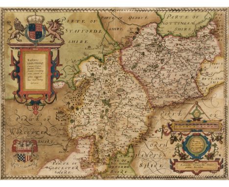
Lot 127
Warwickshire and Leicestershire. Saxton (Christopher), Warwic Lecestriaeq. Comita Civitat. Oppidoru. Villaru. Fluminu. Ceterarumq. Rerum omnium in eisdem memorabilium, nova, veraq. descriptio, [1579], engraved map by Leonard Terwoort, contemporary hand colouring with some later enhancement, elaborate strapwork cartouche and mileage scale, the latter surmounted by dividers, coat-of-arms of Elizabeth I with the addition of the heraldic crest of Thomas Seckford, some oxidization causing small areas of cracking and splitting and slight loss, trimmed to decorative margin and laid on later card, slight staining, 390 x 520 mm, framed and glazedQTY: (1)NOTE:The first printed map of Warwickshire and Leicestershire from the earliest national atlas of England and Wales.
Lot 27
British Isles. De Wit (Frederick), Novissima prae caeteris aliis accuratissima Regnorum Angliae Scotiae Hiberniae..., Amsterdam circa 1690, engraved map with contemporary outline colouring, inset map of the Orkney, Faroes and Shetland Islands, decorative cartouche and mileage scale, slight oxidisation to old watercolour causing small cracks and splits, repaired on verso, occasional marginal closed tears, 590 x 500 mmQTY: (1)NOTE:R. W. Shirley. Printed Maps of the British Isles, 1650 - 1750. De Wit 6, state 2.
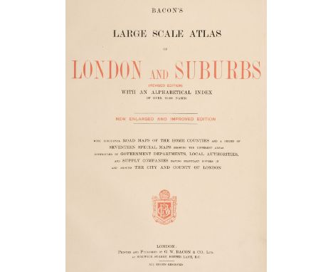
Lot 279
Bacon (G. W. publisher). Bacon's Large Scale Atlas of London and Suburb (revised Edition) with an Alphabetical Index..., circa 1920s, title and contents list, contents page with long closed repaired tear, 7 lithographic double-page county maps, 20 maps of London, index map and 35 sheet map of London, publisher's half morocco, worn and bumped, folio, together with Bacon's Popular Atlas of the British Isles..., 1907, additional half-title, preface and contents, 72 double-page colour lithographic maps and diagrams and charts, upper hinge weak, publisher's decorative gilt cloth, a little frayed along the spine, folio, with Bacon's General Atlas of the World with Index, circa 1930, title and contents, frontispiece of national flags and 49 double-page colour lithographic maps, index bound at rear, manuscript presentation inscription to first front blank, hinges weak, contemporary half morocco gilt, worn and rubbed at extremities, folioQTY: (3)


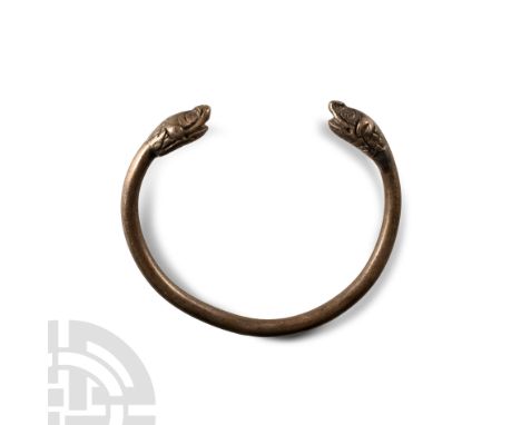
Lot 1190
1st millennium B.C. Comprising a large round-section body and flattened finials with stylised beast-heads, incised scale detailing to the neck and head, scrolled nostrils. 95 grams, 91 mm (3 1/2 in.). UK private collection before 2000.On the UK art market.Property of a London gentleman. [No Reserve]
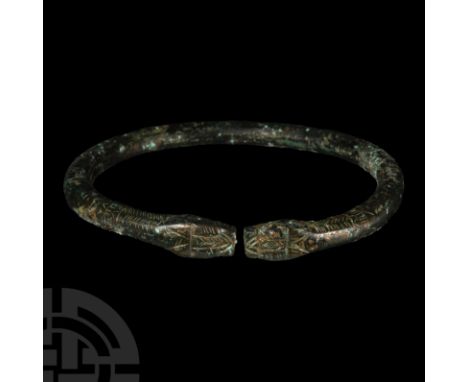
Lot 1571
Circa 9th-11th century A.D.. Penannular, round in section with punched scale detailing to the shank, opposed snake-head finials. 30.26 grams, 78 mm (3 in.). Property of the vendor's grandfather, thence by family descent, circa 1985.From the private collection of a New York, USA gentleman. [No Reserve]
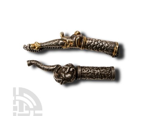
Lot 1842
20th century A.D.. Group of two silver-coloured metal drinking-horn finials comprising: tubular body developing to an elephant's head with recurved trunk; tubular body with scale detailing, parcel-gilt monstrous head with jaws open and fish between, stopper to the fish's tail with securing chain. 123 grams total, 11.2-12 cm (4 3/8 - 4 3/4 in.). Property of a South West London gentleman. [2, No Reserve]
-
214876 item(s)/page