We found 1529 price guide item(s) matching your search
There are 1529 lots that match your search criteria. Subscribe now to get instant access to the full price guide service.
Click here to subscribe- List
- Grid
-
1529 item(s)/page

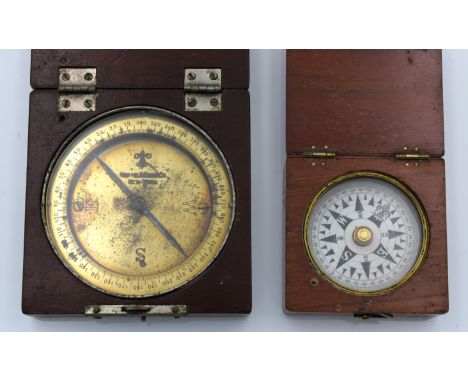
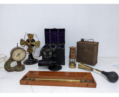
Lot 350
An antique wooden cased surveyor compass by Keuffel & Esser, New-York, 4 cardinal points (fleur-de-lis for North) on polished brass plate with an outer raised ring, the mahogany box stamped 'D 22 B' to hinged cover and one side, the other side stamped '1669', the inner lid inscribed 'G. L. Felix 32", 7.7cm. square, together with another compass. (2) * The Keuffel and Esser Co., also known as K&E, was an American drafting instrument and supplies company founded in 1867 by German immigrants Wilhelm J. D. Keuffel and Hermann Esser. It was the first U.S. company to specialize in these products.
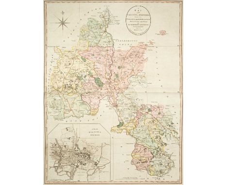
Lot 414
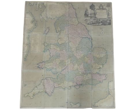
Davis (Richard) A New Map of the County of Oxford from an Actual Survey; on which are Delineated the Course of the Rivers and Roads, the Parks, Gentlemen's Seats, Heaths, Woods, Forests, Commons &c. &c., London: John Cary, 1797, key map of Oxfordshire with original hand colouring and inset b & w town plan of Oxford, seventeen map sheets (including title page) all with original hand colouring, each plate approximately 49cm x 67cm, rebound in a modern large folio (58cm x 41cm) in half calf with marbled boards and red morocco title label, new endpapers, pencil booksellers notation to front pastedown with pasted blind stamped bookplate and signature 'H. George Fordham, Odsey, 1918'A private collection. Previously Sir Herbert George Fordham (1854–1929), a writer on cartography whose Carto-Bibliography method of cataloguing maps was widely adopted. He attended University College, London. He was the benefactor of the Fordham collection housed by the Royal Geographical Society. He received a knighthood in 1908 and from 1920 was Deputy Lieutenant of Cambridgeshire. He donated rare maps and atlases to both the British Museum and to Cambridge University Library and he bequeathed 1300 volumes, including rare road books and itineraries, to the Royal Geographical Society. His house, 66 Odsey House, was built as a racing lodge close to Odsey racecourse by the Duke of Devonshire, and had been in the hands of the Fordham family since 1793This detailed and accurate map of Oxfordshire with its fine town plan of Oxford is Davis’s only contribution to English cartography, although he was a prolific surveyor of estates in and around Oxfordshire. Surveyed on a scale of 2 inches to 1 mile this map is widely regarded as an important land mark in large scale cartography. Brian Kentish. Large Scale County maps of England and Wales 1705-1832, no.45
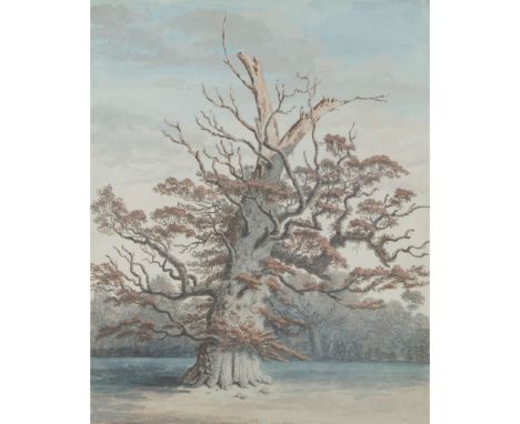
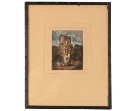
Lot 73
ISAAC JOHNSON (BRITISH 1754-1835) OAK TREE AT WINFARTHING inscribed ‘Drawn 1785 by I Johnson, Woodbridge’ to margin lower right, watercolour, gouache, pen and ink 38cm x 31cm (15in x 12 ¼in) Simon Carter;R Geoffrey Smith, Beveriche Manor Farm, Middleton Literature: John Blatchly, Isaac Johnson of Woodbridge: Georgian Surveyor and Artist, J. M. Blatchly, Dorset, 2014, pp.14-16Huon Mallalieu, The Dictionary of British Watercolour Artists up to 1920, vol. III, Antique Collectors' Club, Woodbridge, 1990, repr. p.191This oak stands in Winfarthing, Norfolk on the estate of the Rt. Hon. Lord Albermarle.
Lot 36
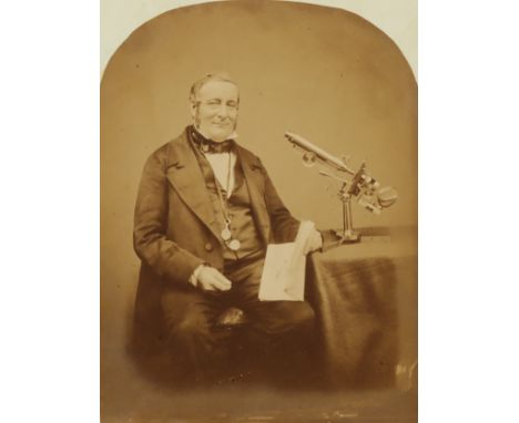
Maull & Polyblank, Albumen Print of Frederick Walter Simms, F.R.A.S.,Maull & Polyblank, the image, with arched top mounted on period paper with manuscript title 'F. W. Simms, F.R.A.S.' the the base of the image, depicting a seated gentleman next to a Smith Beck & Beck, No.1 folding microscope with Varly stage, image 155mm x 208mm, in modern card mountFrederick Walter Simms (24 December 1803 – 27 February 1865) was a British civil engineer, known for his association with the Greenwich Observatory. He was the brother of William Simms (1793–1860), who, alongside his partner Edward Troughton formed the company of scientific instrument makers Troughton & Simms.Before joining the Greenwich Observatory in 1830, Simms apprenticed as a surveyor and contributed to the Trigonometrical Survey of Ireland. His tenure at the Observatory began when Thomas Glanville Taylor departed for the Directorship of the Madras Observatory. By 1835, Simms' responsibilities, as listed by John Pond, included observations with the Zenith Tube alongside John Henry Belville, occasional work with other instruments, proofreading printed observations with Henry, and overseeing the publication process of the annual volumes of Greenwich Observations. While Pond commended Simms as "very able and diligent," he also noted irregularities in chronometer rates, which eventually led to expectations of retirement.Despite being paid a modest salary supplemented by earnings from navigation lessons and surveying tasks, Simms found the financial arrangement insufficient. His dissatisfaction culminated in his resignation on 21 October 1835, shortly after the arrival of the new Astronomer Royal, Airy. Airy, in his autobiography, remarked that Simms had hoped for the position of First Assistant, a role for which Airy deemed him unfit.Following his departure from the Observatory, Simms pursued a new career path as a railway surveyor and engineer. In 1836, Simms commenced his role as a resident engineer with the South Eastern Railway Company, embarking on various significant projects, including the construction of the Bletchingley and Saltwood tunnels. He authored several books on surveying and tunnelling and produced the 1838 Map of The Parish of Greenwich in the County of Kent for the Tithe Commissioners.In 1846, the East India Company, seeking to expand railway infrastructure in their territories, approached Simms to serve as their consulting engineer in India. Despite grappling with health issues exacerbated by the climate, Simms briefly sojourned in Mauritius before resuming his duties. Among his responsibilities was overseeing the comprehensive survey and mapping of Calcutta, primarily conducted by local assistants.Upon concluding his tenure with the East India Company, Simms returned to England in 1851, his health notably deteriorated due to the harsh conditions in India. He subsequently retired from active professional life.
Lot 367
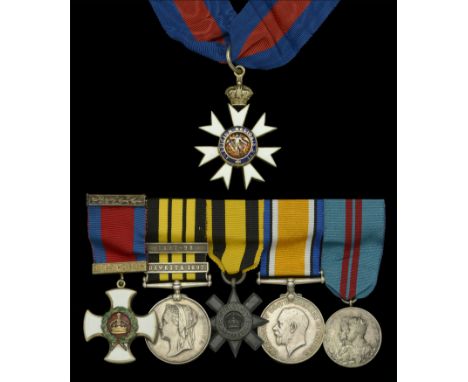
The unique Ashanti 1896 C.M.G., Dawkita 1897 D.S.O. group of six awarded to Commander F. B. Henderson, Royal Navy - the remarkable defence of Dawkita, over four days and nights, with 40-odd men pitched against an army of Sofas 7000 strong, stands out as one of the great epics of Empire, so too Henderson’s extraordinary bravery in giving himself up to the enemy to parley for the freedom of his men; he refused to kneel before the Samory and his elders, even having been shown the head of his most trusted officer The Most Distinguished Order of St. Michael and St. George, C.M.G., neck badge, silver-gilt and enamels; Distinguished Service Order, V.R., silver-gilt and enamels, with integral top riband bar; East and West Africa 1887-1900, 2 clasps, Dawkita 1897, 1897-98 (Lieut. F. B. Henderson. R.N.) second clasp loose on ribbon; Ashanti Star 1896; British War Medal 1914-20 (Commr. F. B. Henderson. R.N.); Coronation 1911, enamel work slightly chipped in places, generally very fine and better (6) £30,000-£40,000 --- Importation Duty This lot is subject to importation duty of 5% on the hammer price unless exported outside the UK --- --- Provenance: Richard Magor Collection, Dix Noonan Webb, July 2003. C.M.G. London Gazette 26 June 1902. D.S.O. London Gazette 8 March 1898: ‘In recognition of services in conducting operations against the Sofas in 1897.’ Francis Barkley Henderson was born in Ely, Cambridgeshire on 8 July 1859, fourth son of the Rev. J. H. Henderson and Anne, daughter of Rear-Admiral H. G. Morris, R.N. Educated at Britannia, he was appointed a Midshipman in October 1874 and, four years later, on promotion to Sub. Lieutenant, he joined H.M.S. Bacchante, sailing in her during her world cruise with the Dukes of York and Clarence as fellow Midshipmen. And on passing for Lieutenant in June 1882, he was awarded the Goodenough Medal for the best examination in gunnery. But in July 1884, his promising career seemingly came to a halt, when he was invalided from the active list. In the following year, however, he took up appointment as Private Secretary and A.D.C. to Sir W. E. Maxwell, K.C.M.G., Governor of the Gold Coast Colony, and accompanied him to Kumassi during the Ashanti Expedition of 1896, experience that no doubt assisted him in gaining appointment as a Travelling Commissioner in the Colony for the next six years. And it was during the course of this appointment that he commanded the small force allocated to the Defence of Dawkita in 1897. Not enough, perhaps, has been written of this gallant little affair, but in his Africa General Service Medals, Richard Magor provides a full and entertaining account of proceedings. As the author successfully illustrates, Henderson’s feat is wholly worthy of comparison to other 19th century epics, Rorke’s Drift among them. For reasons discussed at length by Magor, including aggressive behaviour towards Europeans and friendly tribesmen, Henderson raised the Union Flag at Dawkita in the full knowledge that his actions might be met with severe local opposition. Apart from anything else, the Sofas were said to be starving and his occupation of Dawkita effectively blocked their way to forage for food. He also took the trouble to warn the appropriate Chiefs that if they continued to molest his people, their actions would be considered as hostile ones This, of course, was like a red rag to a bull, and within a short period of time, the Sofas were on the warpath to Henderson’s little three-compound settlement. Henderson takes up the story in his subsequent despatch: ‘The Sofa army appeared over the hill in front of the town, massed in a huge square, numbering, as far as we could estimate, about 7000 men. Their mounted men, of whom they had about 400, tried to pass to the rear of the town on our left, but were driven back by some Lobis, and then, passing along the river bank, occupied the water-hole distant about 350 yards from our front. The Bonas, who were to have held this, made no resistance. I felt very much the want of this water-hole, want of water being one of the chief causes of my having, eventually, to retire. At 4.30 p.m. their riflemen (numbering over 1000) opened a heavy fire on us from the cover of the bush. They showed some skill in skirmishing and their fire was well directed, though high. I had been informed on good authority that they were very short of ammunition, but this want had evidently been supplied from some source, as they were able to keep up an almost un-intermittent fire through that night, the next day and the best part of the next night, and at intervals heavily for the rest of the four days. At night I only replied to their fire by an occasional volley, when they came to the edge of their cover.’ Such were the odds faced by the gallant defenders of Dawkita, a tiny force of arms comprising an African surveyor, Mr. George E. Ferguson, a native Police Officer and 41 Constables of the Gold Coast Constabulary, all of whom, under their gallant commander, found themselves pitched against the full might of several thousand Sofas, an army which they engaged and held off for four days and nights. Amazingly, given that they were outnumbered by 160-1, the defenders suffered just two men killed and eight wounded, while the Sofas are believed to have lost at least 400 warriors. It had been at dusk on the fourth day of the defence that Henderson had decided to evacuate Dawkita and retire to Wa, where reinforcements were expected, and after marching through the night, he duly met up with Captain Cramer, who had 50 men, two guns and some rocket launchers. Henderson later reported in his despatch that he regretted having to leave the Government’s tent behind, which had been used as an awning in the defence and was ‘riddled with bullets’, but was pleased to report that the Union Flag, which ‘had been flying since my occupation of the place’, was saved. He also made light of what had clearly been a terrifying 40-mile dash for Wa. Inevitably, however, this bid for freedom proved in vain, for the agitated Sofas hot-footed it to Wa, encircled Henderson’s barely increased force and recommenced hostilities. Painfully aware that their position was now hopeless, and in a desperate attempt to save his men, Henderson put his life on the line by suggesting he parley with the enemy Prince, whom he knew to be both ‘treacherous and cruel.’ His despatch continues: ‘I then laid this proposition before the other officers, who at first opposed the plan on the grounds of the risk I should incur, Ferguson especially saying that I should be uselessly courting death in some unpleasant form. In the end they concurred and a letter was written to the Prince stating that we had not come here to fight his people and could not understand why he had followed me here ... ’ Of subsequent developments, Magor states: ‘The next morning a Chief came to the British to enter into further discussion, and for reasons unknown, other than Henderson’s extreme gallantry, it was decided that he would indeed have to accompany the Chief back to his Prince for a face to face encounter of the terrifying kind. Given the near suicidal nature of this undertaking, it was decided that if Henderson was detained by the Prince, his men were to evacuate Wa as soon as possible. Henderson found the Prince surrounded by all his Chiefs and young courtiers and behind them about 1000 riflemen. The palaver commenced and after the usual preliminaries Henderson said he had not come to fight the Sofas but to prevent the French from occupying the country. He confirmed that he wished to march to Daboya en route for Kumassi. Just a...
Lot 229
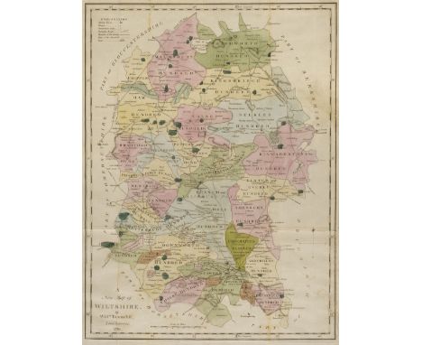
Tunnicliffe (William). A New Map of Wiltshire by Willm. Tunnicliffe, Land Surveyor, 1791, engraved map with contemporary wash colouring, old folds, 490 x 370 mm, supplied with a triangular mileage table for Wiltshire and 24 pages of descriptive text, tables and heraldic shields, together with Kitchin (Thomas). Bowles's Reduced Map of Sussex [1769 - 74], an uncoloured engraved map, large margins, old folds, 160 x 320 mm, with Blome (Richard). A Mapp of Hantshire [1673], an uncoloured engraved map, very slight marginal toning and creasing, 305 x 265 mm, plus Kitchin (Thomas). Untitled map of Hampshire [1769], uncoloured engraved map, first state before the addition of a title, 235 x 210 mmQTY: (4)
Lot 382
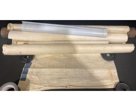
Document: Enclosure award – Appointment of Mr. King to be a commissioner under the Lenton & Radford Enclosure Act in the place of Mr. Robert Padley, 16th November 1796, 32 x 11cm (extended with threaded attachment); 11 leaf vellum enclosure survey document and rubric signed by the commissioners including original survey plan of Lenton and Radford by John Bailey; 20th century reproduction of the survey plan of the ‘Forests, Commons and waste lands within the parishes of Lenton & Radford Inclosed buy an Act of 1796’, after the original by John Bailey, surveyor; original 39.5in. (100.5cm) black japanned tin document cylinder with detachable lid (3)
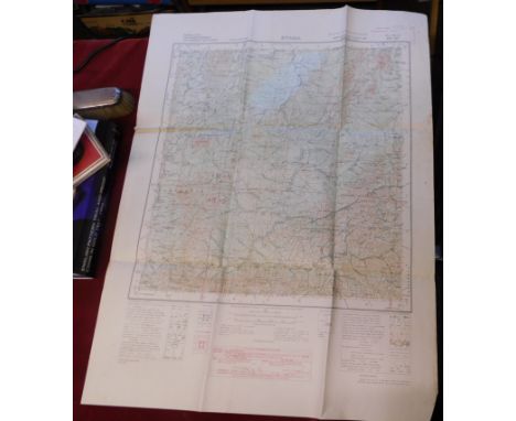
![[AUSTRALIA etc.] No. 10 South Australia. Surveyor-General's Report, 1912-13, folio, folding map, comps slip, cloth; Singapore](https://cdn.globalauctionplatform.com/feaa7a89-a56c-414a-a853-b27600f92c71/0f63f501-d07f-4375-bee4-b27600fb9fd2/468x382.jpg)
Lot 9
John Rocque (1704–1762) Plan de la ville et faubourgs d' Exeter ..., A fine plan adorned with nine large vignettes of buildings and views in Exeter and its rural environs, engraving by R. White, on two sheets conjoined, backed onto linen, light spotting to edges, slight splitting of paper from linen to left edge centre fold, 75cm x 122.5cm scarce, 1744.Published two years before Rocque's monumental plan of London. Vignette views include: Exe Bridge; The Guild-Hall; The West Prospect of the Cathedral of St Peter; The North View of the Castle; The City Hospital; The City and County Hospital; The Prospect of the Custom House; The Work House; and The North Prospect of the Cathedral of St Peter. A small vignette just above the French title cartouche appears a portrait of a surveyor at work, presumably Rocque himself.
Lot 123
* Kent Estate Plans & Rentals. A group of approximately 20 manuscript items by and relating to Lee Warly, mostly 18th century, including A rough sketch of Pimphurst Farm in Bethersden, Kent, belonging to Mr Lee Warly, surveyed in 1784..., H. Hogben, surveyor, pen and ink and colour wash on paper with additional manuscript explanation, references, etc., made by Lee Warly (who purchased this farm of William Kennett), laid down on thicker paper by Warly with his endorsement to verso, some spotting and minor wear to left margin, 42.5 x 77 cm, together with 7 other small pen and ink and wash estate plans by and relating to Lee Warly's properties in Kent, including; A map of the Rose and Crown Inn…, Elham, Kent, 1746, 20 x 24.5 cm; Plan of a cottage called Foxes in the Hole, Denton, Elham, Kent, 1746, a copy, 16 x 20 cm; Plan of land called Greenway in the parish of Sutton near Dover… in the occupation of Dan: Warman, 1746, 21 x 20 cm; and similar (one damaged with minor loss); plus 10 other mostly 18th-century manuscript items relating to Lee Warly and family, mostly rentals and related for properties in Kent, including a rental book, 1818-1849, with rents due to George Plomer, George Plomer Jr and George Daniel Plomer, names of tenants include Henry Oxenden, William Fox, Mrs. Fagg, Mr Brasier, Mr Adley, Mr Luckhurst, Mrs Gorely and Miss Larcher, a total of approximately 125 leaves, mostly written to rectos only, contemporary vellum with Lee Warly's name to upper cover and front pastedown, some soiling and wear, 31 × 20.5 cmQTY: (approx. 20)
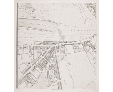
Lot 95
A plan of Knightsbridge from what Howgego describes as the 'largest and most important London map of the eighteenth century', on a scale of 26 inches to a mile. It shows Hyde Park and the Serpentine, with Knightsbridge, the Brompton Road and Sloane Street. Horwood's intention was to mark each house's number (a practice started in 1735), but this was abandoned as impractical. He started his scheme in 1790, expecting to be finished by 1792: by 1794 he was apologising to his subscribers (including George III); in 1798 he received a loan of £500 from the Phoenix Fire-Office, for whom Horwood worked as a surveyor, to finish the map. However this assistance was not enough to stop Horwood dying in poverty in 1803. Size: 56.5 x 52.5 cm. Condition: a good example. Published: London: 1794. Keywords: London, antique map, survey of London, Knightsbridge, England, Chelsea, West London, town plan, city plan, engraving, etching
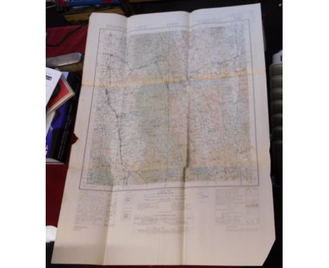
![Freycinet, Louis de Voyage de Découvertes aux Terres Australes. Historique [Atlas. Deuxième Partie] Paris: [Imprimerie Imper](https://cdn.globalauctionplatform.com/27131697-cb4f-46e6-9e88-b26600db8006/50009276-7524-4f16-b861-b26600dc5c5d/468x382.jpg)
Lot 119
Freycinet, Louis de Voyage de Découvertes aux Terres Australes. Historique [Atlas. Deuxième Partie] Paris: [Imprimerie Imperiale], 1811. Large 4to (31.5 x 26cm), atlas volume, second part, only comprising title, index pages and 14 maps (two of which are folding), marbled calf with gilt foliate borders to covers, spine gilt with black morocco lettering pieces, some minor rubbing to covers, joints a little weak and splitting slightly, a couple of very neatly repaired closed tears to folding maps, some minor foxing, small, light, marginal dampstain to final map, one early ink mark mainly affecting fore-edges De Freycinet’s work is notable for containing the first detailed and complete map of Australia. Louis de Freycinet (1779-1841) acted as the cartographer and surveyor for Nicolas Thomas Baudin’s expedition to the Southern and South-Western Coasts of Australia in 1800. Subsequently, he captained the schooner Casuarina around the Australian coastline from 1802-1803, in particular reaching Van Diemen's Land (today’s Tasmania) before heading to Sydney and finally returning to France in 1804. Baudin had passed away in Mauritius in 1803.The first inshore circumnavigation of Australia (at the time New Holland) had been undertaken by the British Royal Navy officer, Matthew Flinders, between 1791 and 1803. It is probable that Flinders would have had the honour of producing the first complete map of Australia had he not been arrested by the French in Mauritius on his return journey. Flinders’s six-year imprisonment offered de Freycinet the opportunity to publish the large folding map of Australia, contained herein, in 1811, three years before Flinders was able to produce his work.De Freycinet’s Atlas is central to the history of European exploration of Australia, showing a clear French claim on the land. Hill points out the De Freycinet: "entirely ignored the discoveries of British explorers, and depicted the whole of the south coast, from what is now Melbourne to the border of Western Australia, as the 'Terre Napoleon'"
Lot 22
Elizabeth I's chief minister.- Cecil (William, first Baron Burghley, royal minister, 1520/21-98) Agreement between Lord Burghley and Richard Kingesmill , Surveyor of the Liveries, on the one part, and John Aylwyn of the other part, stating that the general livery of all lands of his father are to be granted to Alwyn, with an attached Valor in Latin, specifying the lands in Heyshott and West Dean in West Sussex alluded to in the agreement, subsigned"Churchill" and "W. Cooke", 2 sheets, manuscript in English and Latin, on vellum, folds, slightly creased, lacks seals, 325 x 545mm. & 285 x 276mm., 2nd November 1596; and another, an engraved portrait of Burghley, v.s., v.d. (2).
Lot 68
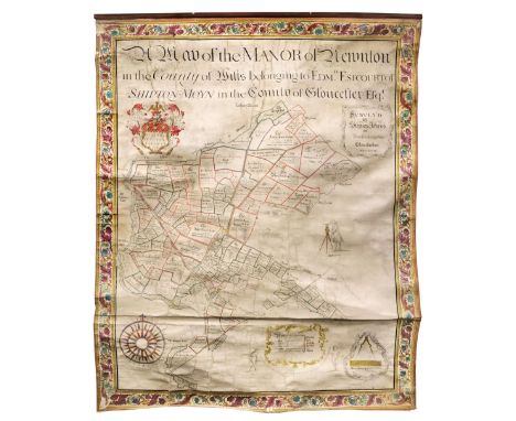
Estate Plan. A Map of the Manor of Newnton in the County of Wilts. Belonging to Edmn. Estcourt of Shipton Moyne in the County of Gloucester Esqr. Surveyed by Stephen Jefferys of Minchinhampton Gloucestershire, 1748, a very large manuscript estate plan of ink and watercolour on vellum, calligraphic title and cartouche, heraldic crest, table of explanation, compass rose, a scale of distance surmounted by dividers, and a portrait of the surveyor stating that he was aged 68, the margins decorated with a 'freize' of an etched floriate design with contemporary hand-colouring laid on to the vellum, slight fraying to the foliate border, some dust soiling and slight creasing, one small hole in the margins, with a stained early 20th-century wooden batten attached to the upper margin, 1980 x 1650 mmQTY: (1)NOTE:An unusually large and highly decorative estate plan.It has been noted that the above items may contain manorial documents, which are subject to the Manorial Documents Rules 1959, 1963 and 1967, administered by The Historical Manuscripts Commission at The National Archives on behalf of the Master of the Rolls. Accordingly, the purchasers of the documents must notify the Secretary of the Commission of their acquisition and provide details of where they will be kept. They may in no circumstances be removed from England and Wales without the prior consent of the Master of the Rolls. Every change of ownership must be reported.
Lot 70
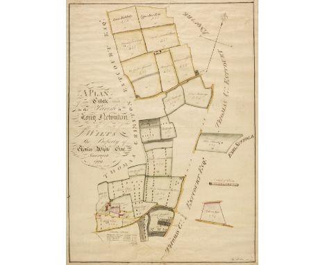
Estate Plans. A Plan of an Estate Situate in the Parish of Long Newnton in the County of Wilts. The Property of Thomas White Gent. Surveyed in 1799 by S. Dickins, Devizes, a copy 1822, ink and watercolour plan on paper, large calligraphic cartouche, simple compass rose, some later pencil annotations, slight creasing, the whole bordered in pink silk and laid on hessian, 705 x 515 mm, together with Map of Lark Hill Farm in the Parish of Newnton, Wilts. belonging to T. G. Estcourt Esqr. 1811, John Hayward, Surveyor, Rowle, Wilts., pen and watercolour estate plan, circular cartouche, simple compass rose, table of reference, scale of chains, slight dust soiling and spotting, the whole bordered with blue silk and laid on linen, displayed on contemporary stained and turned wooden battens, 500 x 735 mm, with Pinnell (T.). A Plan of an Estate Situate in the Parish of Newnton and County of Wilts. Belonging to Daniel Adey Esqr. 1783, ink and watercolour estate plan on vellum, foliate cartouche and compass rose, some dust soiling and creasing, 620 x 375 mm, with another five pen and ink plans similar, various sizes and conditionQTY: (8)
Lot 25
Mathematician sells his school.- Agreement between Charles Hutton and John Fryer regarding the sale of schoolrooms in Newcastle upon Tyne, manuscript copy, 1½pp., docket title, folds, lightly browned, folio, Newcastle upon Tyne, 14th June, 1773. *** Charles Hutton (1737-1823), English mathematician and surveyor. In 1773 he was appointed Professor of Mathematics at the Royal Military Academy, Woolwich. Fryer had been Hutton's pupil and later assistant.
Lot 1195
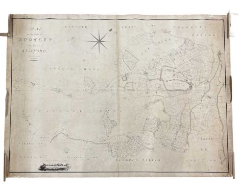
1815. Staffordshire.- Robins (Ebenezer, surveyor) Map of the Parish of Rugeley in the County of Stafford, large map with watercolour wash lining, 4 sheets joined, linen-backed, ink name of Robert Curzon to verso, 117cm x 157cm 1815. Rugeley, on the edge of Cannock Chase. Hagley Hall and Park, can be seen close to the centre of the village.
Lot 99
MCARTHUR JOHN, Surveyor in Glasgow. Plan of the City of Glasgow, Gorbells and Caltoun. Large eng. fldg. linen plan. Title & dedication vignettes. 38" x 49". 1778; also a large fldg. linen OS map, Environs of Glasgow, 1":1mile, hand colouring, 1885. (2) Condition report:Map has separated from boards.Ingrained dirt and stains to map surface.Holes and losses to map, especially at the edges.
Lot 222
British WWII Map of Burma, Third Edition (Toungoo, Karenni, Salween, Tharrawaddy ref: 94B). Published for the Government of Burma under the direction of the Surveyor General of India. From the estate of the late 172437 Lt T.L. Waring, 239/115 Field Regiment Royal Artillery, India Command 19th Division.
Lot 228
British WWII Map of Burma, Second Edition (Bhamo, Katha and Shwebo Districts and Northern Shan States ref: 93A Mong Mit). Published under the direction of Brigadier H.J. Couchman, D.S.O., M., Surveyor General of India. From the estate of the late 172437 Lt T.L. Waring, 239/115 Field Regiment Royal Artillery, India Command 19th Division.
Lot 221
British WWII Map of Burma, Edition: 1941 (Yamethin, Meiktila, Southern Shan States ref: 93D). Published for the Government of Burma under the direction of the Surveyor General of India. From the estate of the late 172437 Lt T.L. Waring, 239/115 Field Regiment Royal Artillery, India Command 19th Division.
Lot 223
British WWII Map of Burma, Second Edition (Bhamo, Upper Chindwin, Katha & Myitkyina Districts and Northern Shan States ref: 92D Katha). Published under the direction of Colonel C.H.D. Ryder, C.B., C.I.E., D.S.O., R.E., Surveyor General of India. From the estate of the late 172437 Lt T.L. Waring, 239/115 Field Regiment Royal Artillery, India Command 19th Division.
Lot 224
British WWII Map of Burma, (Upper Chindin, Katha and Myitkyina Districts. Ref: 83P Banmauk/Pinlebu). Published under the direction of Brigadier C.G. Lewis O.B.E., Surveyor General of India 1937. From the estate of the late 172437 Lt T.L. Waring, 239/115 Field Regiment Royal Artillery, India Command 19th Division.
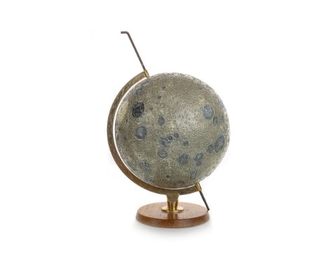
Lot 1002
fibreglass sphere modelled in relief with the moon's named seas and mountains, further hand-annotated with landing sites - American unmanned 'Surveyor' and 'Ranger' landing sites are marked with yellow squares; the Russian unmanned 'Lunar' sites are marked in red; the manned 'Apollo' missions (11 and 12, both 1969) are marked in blue, on brass axis and circular oak base the globe 26cm diameter
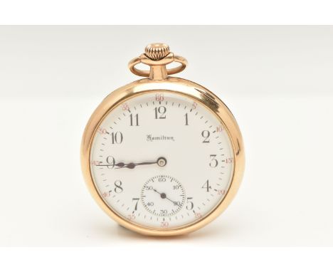
Lot 482
A YELLOW METAL 'HAMILTON' OPEN FACE POCKET WATCH, hand wound movement, round white dial signed 'Hamilton', Arabic numerals, subsidiary second dial at the six o'clock position, yellow metal case with monogram engraving to case back, approximate case width 45mm, inside case back and dust cover stamped 14k, dust cover engraved 'Presented to Mr Wm Butler Senior surveyor by his colleagues as a token of esteem on the occasion of his leaving the Pittsburgh district Sept 1919', movement signed 'Hamilton watch co Lancaster Pa' numbered 1854695, approximate gross weight 65.8 grams (condition report: general moderate wear, winds and runs at the time of cataloguing, time keeping not tested, we cannot guarantee the working condition of the watch)


Lot 1002
ARTHUR WIGHTMAN OF CORNWALL, RARE LUNAR GLOBE, CIRCA 1969 fibreglass sphere modelled in relief with the moon's named seas and mountains, further hand-annotated with landing sites - American unmanned 'Surveyor' and 'Ranger' landing sites are marked with yellow squares; the Russian unmanned 'Lunar' sites are marked in red; the manned 'Apollo' missions (11 and 12, both 1969) are marked in blue, on brass axis and circular oak basethe globe 26cm diameter
Lot 32
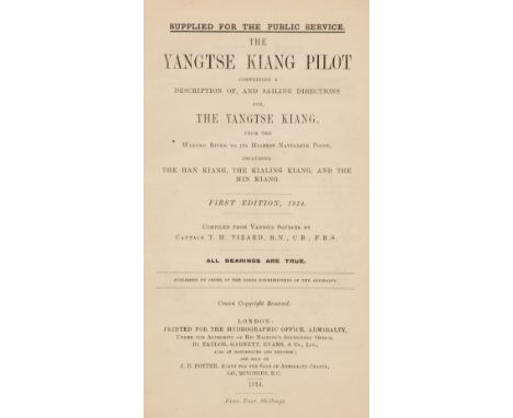
Tizard (Thomas Henry). The Yangtse Kiang Pilot. Containing a Description of, and Sailing Directions for the Yangtse Kiang, from the Wusung River to its highest navigable point, including the Han Kiang, the Kialing Kiang, and the Min Kiang, 1st edition, London: printed for the Hydrographic Office, Admiralty, 1914, folding charts and diagrams, monochrome illustrations, occasional light spotting, original limp cloth, spine a little toned with small splits to joints, light dust-soiling, 8voQTY: (1)NOTE:Provenance: Ethel A. Tizard (daughter of the author), her signature at head of first leaf. Thomas Henry Tizard (1839-1924), oceanographer and hydrographic surveyor, served on board HMS Challenger between 1872 and 1876, and authored several of the Challenger Reports.
Lot 558
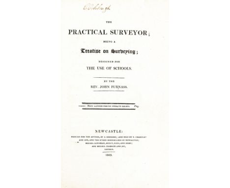
Surveying: Furnass (Rev. J.) The Practical Surveyor; being a Treatise on Surveying; designed for Schools, 8vo Newcastle 1809. Hf. title, fold. & other plans & maps, (hd. cold. in outline) text, illus., uncut, orig. boards. With paper slip 'With The Author's Compliments' tipped - in at front; also A Treatise on Practical Surveying and Topographical Plan Drawing, 8vo Lond. 1829, with 2 fold. plans, errata slip; Bound with, Burr (G.D.) A Short Essay on Sketching Ground without Instruments, Lond. 1830, text illus., & 6 fold. plts., a.e.g., in full green mor. gilt Prize Binding from Royal Military College. V. good. (2)
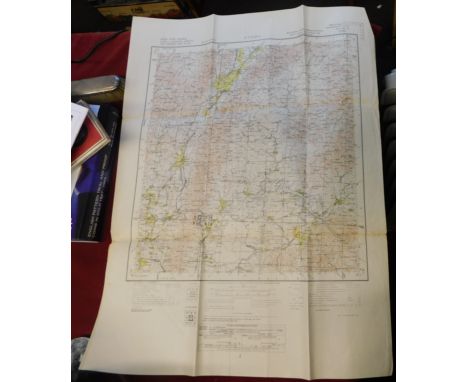
![Exceptionally Rare Report on Dublin Bay, 1800 [Bligh, (Wm.), Pagte (Thos. Hyde), & Rennie (John) et al.] The Directors Ge](https://cdn.globalauctionplatform.com/549da13f-ed0e-4f30-b9f1-b22d00cc78d4/d3a6c56e-c7ea-4683-83e7-b23001035583/468x382.jpg)
Lot 799
Exceptionally Rare Report on Dublin Bay, 1800 [Bligh, (Wm.), Pagte (Thos. Hyde), & Rennie (John) et al.] The Directors General of Inland Navigation in Ireland, to whom in Pursuance of the Act of the 40th Year of his Majesty's Reign, the Improvement of the harbour of Dublin is committed, have caused the following Reports to be printed, with a Map annexed to each, upon which is delineated a Sketch of the Works proposed by the several Reports to be constructed for the Purpose. The Sketch will elucidate the Report, and give a general idea of the Design. With six folding maps each outlying in red the proposals from the engineers. Dublin 1801, folio pp. 84., cont. full tree calf, upr. joint cracked, spine worn, new mor. label. Very good copy of an extremely rare volume. * The most comprehensive report is that of Captain William Bligh of the 'Bounty' fame. He had great skill as a marine surveyor and hydrographer. The Inlaid Navigation Board secured his services to survey and sound the bay and river estuary. By December, 1800, in appalling weather, he had carried out the most extensive and accurate survey ever accomplished of Dublin Bay. Following on these reports the Directors general submitted their findings to the Lord Lieutenant, Hardwicke, in 1804. The proposals of Page, Rennie and Bligh were not accepted. The Board were seeking a long-term solution, saying: we must not limit our views to alterations of the Harbour calculated for ships of particular build or buthen, for particular times of tide or for particular winds.; The Great North Wall or the Bull Wall as outlined in this report by Captain Daniel Corneille was eventually chosen and constructed between 1819 and 1824. (1)
Lot 404
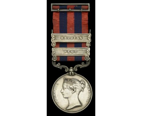
The most important India General Service medal awarded to Ensign Henry Haversham Austen (later Lieutenant-Colonel Godwin-Austen, F.R.S., F.Z.S., F.R.G.S.), who was gazetted to the 24th Foot in 1851 and served as A.D.C. to General Godwin in the 2nd Burmese War, and later on special duty with the Bhootan Field Force; as a young British army surveyor he ‘undertook one of the most remarkable expeditions in British mountaineering history; not only did he open the way to the mountain now called K2 but, beyond the village of Skardu, gateway to the Karakoram, he became the first Westerner to explore the world’s most extensive and awesome glacier system; explorations in Ladakh, Tibet, Bhutan and Burma soon followed’ India General Service 1854-95, 2 clasps, Pegu, Bhootan (Ensign H. H. Austen. 24th Foot. A.D.C.) second clasp loose on ribbon as issued, fitted with silver ribbon buckle, toned good very fine £4,000-£5,000 --- Henry Haversham Austen was born at Teignmouth, Devon, on 6 July 1834, son of Robert A. C. Austen, F.R.S., a distinguished geologist, and Maria, daughter of General Godwin, a marriage that produced no fewer than 17 siblings to Haversham between 1834 and 1856, one of whom, Frederick, was killed at Isandhlwana. Haversham, by which name he was always known, was educated at R.M.C. Sandhurst which establishment he entered at the age of 13. Gentleman Cadet H. H. Austen was appointed as Ensign in the 24th Foot on 26 December 1851, and in June 1852 set out for Burma, as aide-de-camp to his grandfather General Godwin, the commander-in-chief of the British forces in the second Anglo-Burmese war. Following the death of General Godwin in 1854 his name was changed to Godwin-Austen by personal decree of Queen Victoria. He was appointed a Topographical Assistant to the Trigonometrical Survey of India and joined the Kashmir Survey party in 1857, with whom he surveyed a very large extent of country in Kashmir and Baltistan. In the latter country the enormous glaciers at the head of the Shigar river and Hunza Nagar frontier, which included the Baltoro glacier, which he was the first to discover, coming down in part from the second highest mountain in the Himalayas and named after him [since renamed as ‘K2’]. In 1862 he surveyed the lofty country of Rupshu and Zaskar in Ladakh, and in July and August of that year he made 13 different ascents of a mean height of 17,900 feet, the highest peak, Mata, being 20,607 feet. The following year he took up the Changchenmo and carried the topography to the eastern end of the Pang Kong lake, close up to Rudok in Chinese territory, where he was met and stopped by the Lhassan Governor. During the winter of 1863-64 he was on special duty with the last mission to Bhutan, and mapped the country between Darjeeling and Punakha, the capital. In 1864-65, having accompanied the political mission of Sir Ashley Eden to the Rajas of Bhutan, he served on special duty with the left column of the Bhutan field force as Surveyor, and was present at the storm and capture of of the fort of Dalimkot and the stockade of Chamoorchi in December 1864. In 1866, and for the following ten years, he was in charge of Survey Operations in the Garo, Khasi, Jaintia, North Cachar and Naga Hills, and Manipur, including in 1874 the expedition against the Dafia tribe at the base of the Eastern Himalayas, when a large area of new country was mapped and many distant peaks fixed. He was President of Section E (Geography) of the British Association, 1883; President of the Maalacological Society, 1897-99; President of the Conchological Society of Great Britain and Ireland, 1908-09; awarded the Founders’ medal of the Royal Geographical Society in 1910 for his exploration work. He was author of On the Land and Fresh-water Mollusca of India, 1882-1920; (jointly with Dr W. T. Blandford) of The Fauna of British India, vol. Mollusca, 1908; together with some 130 papers in the Journals of various Scientific Societies on Geology and Physical Features, Ethnology and Natural History. Lieutenant-Colonel H. H. Godwin-Austen died at his house near Godalming in the Surrey hills on 2 December 1923. Sold with a copy of Catherine Moorehead’s outstanding 2013 biography of this important but long-forgotten explorer, The K2 Man (and his molluscs) The extraordinary life of Haversham Godwin-Austen, the dust jacket of which carries an excellent précis of the story to be discovered therein: ‘Haversham Godwin-Austen (1834-1923), from an ancient and interesting Surrey aristocratic family with royal connections, not only found the first way to the savage mountain, K2, but went on to be the first serious explorer of the Karakoram, Ladakh, Western Tibet, Bhutan, Northern Burma and Assam. He broke the Asiatic high-altitude summiting record three times, using a ‘garden hatchet’ as an ice-axe, saw his assistant killed by headhunters and socialised with everyone from his ‘coolies' to the Maharajah of Kashmir. Back in England, he became one of the UK's greatest Natural Historians, a Darwinist collector among collectors of geological and ornithological specimens. His collection of freshwater molluscs forms the basis of all modern science in the subject. And he became one of the UK's greatest surveyors, covering over 22,000 square miles of new territory, including 23 new glaciers and at least two dozen first ascents of peaks over 5000m. Remarkably, he also found time to paint a vast portfolio of watercolours, including the first close sighting of K2, described by the British Library as a 'national treasure’. (Several of these watercolours are illustrated in this book.) His personal life was equally interesting: three marriages - to an Afghan landowner's daughter, an English socialite, then a civil servant's daughter 23 years younger than himself - were complicated by religious conversions from Anglicanism to Islam then to Buddhism. His strong character as a scholar at great London institutions such as the Natural History Museum is still the stuff of legend, while his bankruptcy in later life required the selling of the 'family pile’, the magnificent, royally-furnished Shalford Park. And thanks to a youthful indiscretion in Kashmir, he harboured a dark secret which came back to haunt him near the end of his long and colourful life. This is the first and authorised biography of an outstanding man. Godwin-Austen's private papers are being made public for the first time. They prove that he was one of the UK's greatest explorers, on a par with Sir Richard Burton, while surpassing the explorations of David Livingstone, Captain Cook or Captain Scott. For mountaineers, scientists, students of biography and historians of the Raj and the Great Game, this biography offers new and original material - a 'must' for the explorer's bookshelf.’
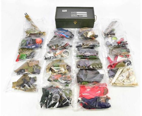
Lot 965
ACTION MAN; a large collection of costumes including Australian jungle fighter, army medic, crash crew uniform, casual sporting clothes, engineer surveyor, tank commander, infantrymen, army medic no. 2, action soldier, German stormtrooper, Red Devil parachute, ski patrol uniform, deep sea diver, astronaut 1967, etc (qty).
Lot 910
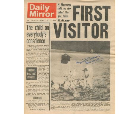
BEAN ALAN: (1932-2018) American astronaut, Lunar Module Pilot of Apollo XII (1969), the fourth man to walk on the moon. A printed folio edition of the Daily Mirror newspaper of Friday, 28th November 1969, with the headline First Visitor above an image of Alan Bean standing in a full-length pose on the surface of the moon alongside Surveyor III, the NASA lunar lander spacecraft which was sent to explore the surface of the moon in 1967. Signed by Bean in blue ink to a light area of the image, also adding Apollo 12 in his hand beneath his signature. Some light age wear, otherwise about VG
Lot 962
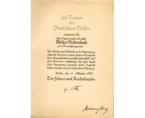
GORING HERMANN: (1893-1946) German politician and military leader, one of the most powerful figures in the Nazi Party who served as President of the Reichstag 1932-45 and as Minister President of Prussia 1933-45. D.S., Hermann Goring, one page, folio, Berlin, 9th October 1939, in German. The partially printed document appoints the government land surveyor Walter Bickenbach to the surveying council, and continues to state ´I make this appointment in the expectation that the appointee will faithfully fulfil his official duties and justify the trust placed in him by this appointment. At the same time, I assure him of my special protection´. Signed by Goring at the foot of the document and also bearing a blue printed facsimile signature of Adolf Hitler, both appearing alongside a blind embossed circular seal featuring the Nazi eagle and swastika. With blank integral leaf. Loosely contained within the original presentation folder featuring the gold embossed Nazi eagle and swastika to the cover. Some light creasing, age wear, and a few small stains and tears, otherwise about VG
Lot 213
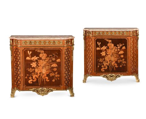
Y A PAIR OF LOUIS XVI ORMOLU MOUNTED, MARQUETRY AND PARQUETRY SIDE CABINETS BY J H RIESENER, ADAPTED FROM CORNER CABINETS Each of slight stepped serpentine form, sycamore, fruitwoods and Amaranth with a rectangular mottled russet marble top inset within gilt bronze petal mouldings, drawer to the frieze mounted with guilloche enclosing flowerheads with acorns and oak leaves, above a pair of tambour doors inlaid with large sprays of moss and cabbage-roses, hollyhocks and tulips, one stamped faintly twice on the front right corner J.H. RIESENER 100cm high, 101cm wide, 29cm deep Provenance: Sotheby's London, 1st July 1966, Lot 134 where described as: 'A HIGHLY IMPORTANT PAIR OF EARLY LOUIS XVI ORMOLU-MOUNTED MARQUETRY AND PARQUETRY SIDE CABINETS, Signed J H Riesener' when purchased for the late owner's mother by Pelham Galleries, London The Estate of a deceased Gentleman. The original 1966 Sotheby's catalogue and a copy of the receipt will be made available to the successful purchaser. Jean-Henri Riesener maître in 1768. In their present form as side cabinets, they can be usefully compared with a single cabinet made by Riesener in 1773 for Pierre-Elisabeth de Fontanieu, the Intendant et Contrôleur Général des Meubles de la Couronne, for his own official residence in the Place Louis XV in Paris. Fontanieu's cabinet was in the famous collection of John Jones, bequeathed to the Victoria & Albert Museum in 1882. Like the present pair, the cabinet was converted from a corner cupboard, probably in the mid-19th century (V&A 1082-1882). Another comparison is with the commode in the Hôtel du Garde Meuble, Paris (Al-Thani collection) which Riesener delivered in 1775 for the bedroom of Madame Randon de Pommery, wife of the Garde-Général of the Garde Meuble de la Couronne. The commode is fitted with almost identical central apron mounts and has strikingly similar guilloche panels to the side frieze drawers - interspersed with comparable oval paterae mounts above comparable scrolling floral feet mounts. The commode was sold from the Desmarais Collection, Christie's New York, 30 April 2019 lot 51, $1,155,000. Literature: Pierre Verlet, Le mobilier Français du XVIIIème Siècle, 1967, pl. 13. F.J.B. Watson, Louis XVI Furniture, fig. 54. P. Kjellberg, The French Furniture of the XVIIIth Century, Paris, 1989, p. 696, cat A. Comparative Literature : Helen Jacobsen, Rufus Bird & Mia Jackson, Jean-Henri Riesener: Cabinetmaker to Louis XVI and Marie Antoinette, London, 2020 We are grateful to Rufus Bird, Deputy Surveyor and Surveyor of the Queen's Works of Art 2010-2021 for his contribution to this catalogue entry. Condition Report: Marks, scratches and abrasions commensurate with age and useSome old chips and splits, some old repairs, some minor losses. Both cabinets have locks to the doors (of late 19th or early 20th century period) The keys are present to operate them. Please note: as catalogued, these have been adapted from their original form. In the original cataloguing it is stated that they are converted from encoignure. It is possible that they were converted from another form of cabinetThe cabinets incorporate various later timbers and veneers throughout. Period elements have likely been adapted also. There is some variation in the construction of the two cabinets. It is impossible to qualify exactly how the conversion has been made. As the cabinets have changed form and the mounts match the current outline of the cabinets, it is likely that some or all gilt metal mounts have been altered/ changed or associated to the cabinets during the process of converting their form. Some repairs to the marble tops with filler to disguise losses and one with disguised metal brace securing an old break at one corner (see images)The cabinets were previously 'anchored'/ secured to the wall in position or would fall forwards. They would need to be secured for use now so they do not fall forwards. There is a chance that the main door panels were not tambour door originally and have been later converted to tambour The elements of marquetry itself appear to be of 18th century period. Please refer to all additional images for visual reference to conditionCondition Report Disclaimer
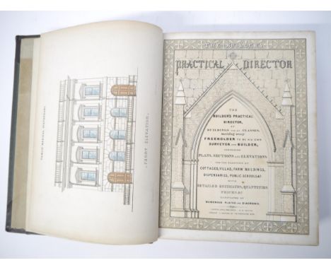
Lot 5248
A.H. Payne: 'The Builder's Practical Director, of buildings for all classes, enabling every freeholder to be his own surveyor and builder; containing plans, sections and elevations for the erection of cottages, villas, farm buildings, dispensaries, public schools etc', Leipzig and Dresden, A.H. Payne; London, J Hagger, [nd], c.1855, illustrated title page + 132 plates, many of which hand coloured, iv,264pp, bound with the Supplementary Series at end, 126pp, 60 plates, many of which hand coloured, 4to (28 x 21cm), contemporary half calf gilt
Lot 5295
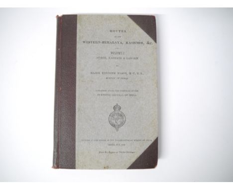
Major Kenneth Mason: 'Routes in the Western-Himalaya, Kashmir, &c. with which are Included Montgomerie's Routes Revised and Rearranged. Volume I - Punch, Kashmir & Ladakh [all published]', printed at Dehra Dun for The Surveyor General of India, 1922, 1st edition, 2 folding maps in rear pocket complete (plus an additional folding map of India & Ceylon from a Bradshaw's Guide, 1928), xvi,[2],273pp, original half cloth over printed paper covered boards. Scarce
Lot 63
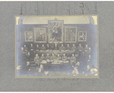
CHURCHILL (WINSTON)Photograph of Winston Churchill (as Secretary of State of War) seated with members of 'The Army Council' beneath a portrait of King Edward VII, SIGNED BY CHURCHILL ('W.S. Churchill') and 8 other sitters, gelatin silver prints on original mount, the signatures vertical in upper margin of mount, captioned 'The Army Council' in ink beneath image, mounted, framed and glazed, image 168 x 228mm., [c.1919]Footnotes:AN UNUSUAL PHOTOGRAPH OF CHURCHILL'S ARMY CABINET AT THE END OF THE FIRST WORLD WAR, SIGNED BY CHURCHILL AS SECRETARY OF STATE.Provenance: Sir James Stevenson (1873-1926), chairman of the Munitions Council's committee on demobilization and reconstruction, and from 1919 to 1921 surveyor-general of supply at the War Office. He was also a member of both the army and air councils (1919–21), ink note 'To be returned to Sir James Stevenson, Room 202, War Office'. He is one of those who has signed the mount, and presumably was responsible for circulating the photograph to be signed. Others who have signed include Lieutenant-General Travers Clarke, 1st Earl Peel (Under-Secretary of State for War, seated to the right of Churchill), and T.H.J. Goodwin. Earl Haig (seated to Churchill's left) has not signed.For further information on this lot please visit Bonhams.com
Lot 74
Kitchin (Thomas); 'A New Map of England & Wales. Drawn from Several Surveys &c. on a New Projection, Corrected from Astronomical Observations & the Places marked where the Observat'ns were made....., The Canals inserted to 1792 by J. Phillips Surveyor', published Laurie & Whittle, 12th May 1794, a large hand coloured engraved map, sectionalised and laid onto linen, approx. 1310mm x 1115 mm, condition as per images, tears, discolouration and fading. Provenance; The Alan Winning Collection of Antiquarian Maps, Books and Atlases. Beginning in the 1970’s with an interest in the 19th Century development of the railway network and the County Maps of this period that charted it, Alan expanded his academic interest into good early printed maps, town plans, travel guides, books and atlases and has been adding to his collection over the past 50 years.
Lot 194
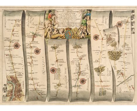
Ogilby (John). The Road from London to Aberistwith on the Sea Coast com. Cardigan wherein are Included the Roads to Oxford and Worcester..., on three sheets [1675 or later], three hand-coloured engraved strip road maps, the first with a decorative cartouche showing a surveyor using a waywiser, the first sheet with repaired marginal closed tears and with the central fold strengthened on the verso, the second sheet a little toned and stained, each approximately 320 x 450 mm, together with The Road from London to Barwick Actually Survey'd and Delineated..., on five sheets [1675 or later], five hand-coloured engraved strip road maps, each approximately 320 x 450 mmQTY: (8)NOTE:Sheet numbers 1, 2 & 3 [and] 5, 6, 7, 8 & 9. Two complete sets.
Lot 5
Frank Humphris : Portrait of Westcott Stile Abell, with coat of arms to the top left (WITHIN THE ARK SAFE FOR EVER 'PASTMASTER OF THE WORSHIPFUL COMPANY OF SHIPWRIGHTS'), colour chalks and bodycolour, signed, dated 1945, 66 cm x 51 cm, framed. CONDITION REPORT: Sir Wescott Stile Abell (1877-1961) was a British naval architect. Born in Exmouth, Devon. He became professor of naval architecture at the University of Liverpool (1910-1914) and chief ship surveyor at Lloyds Register of Shipping, serving as president of the Institute of Marine Engineers (1924-25) and master of the Worshipful Company of Shipwrights (1931-32). In 1928 he resigned his appointment with Lloyds Register to take up the chair of naval architecture at the Armstrong College of Durham University (the precursor institution to Newcastle University). He was also awarded KBE in the 1920 civilian war honours.
Lot 248
Lot Meßgeräte und Vermessungsinstrumente1) Dreiarmiger Winkelmesser, UdSSR, Schenkellänge 59 cm. – 2) Maritimes Roll-Lineal, W.H. Harling Ltd., London, Länge 46 cm, in Holzkasten. – 3) Transporteur, D.R.G.M. 404786, Hatried – Hamburg, Messing, Kurvenlineal, diverse Krümmungen (Kreis, Hyperbel, Parabel), Teil eines Artilleriebestecks. – 4) Rechter Winkel, Messing, Zeicheninstrument. – Und: 5) Loga Topo 6400A, Schweiz, kreisförmiger Duplex-Rechenschieber im Etui, hergestellt für Vermessungsingenieure und Armeezwecke, Durchmesser 12,5 cm. Start Price: EUR 80 Zustand: (2–3/2–3)Lot of Measuring and Surveying Instruments1) Three-arm protractor, USSR, length 23 in. – 2) Maritime parallel rolling rule, W.H. Harling Ltd., London, length 18 ¼ in., in wood case. – 3) Protractor, D.R.G.M. 404786, Hatried – Hamburg, brass, curved ruler, various curvatures (circle, hyperbola, parabola), part of an artillery set. – 4) Right angle, brass, drawing instrument. – And: 5) Loga Topo 6400A, Switzerland, circular duplex surveyor slide rule in case, for surveying and military use, diameter 5 in. Start Price: EUR 80 Condition: (2–3/2–3)
Lot 72
GEORGE MOUNSEY WHEATLEY ATKINSON (1806-1884)The Fleet Getting Away from CorkSignedOil on canvas, 83.5 x 131cmAtkinson was born at Queenstown (Cobh), County Cork to English parents and lived in the Cork area for most of his life. His early years were spent as a ship’s carpenter and he was later appointed Surveyor of Shipping and Emigrants at Cobh. Apparently self-taught, it has been assumed that Atkinson did not take to painting until later in life. However, his Boating Party in Cork Harbour of 1840 (Crawford Art Gallery, Cork), which shows a recreational boating outing, already shows considerable skill. A year later he exhibited five works representing ‘different views of our noble harbour of Cork, in storm, in calm, in haze and in sunshine, together with brigs, schooners, cutters and steamers in every position and circumstance’ at the inaugural exhibition of the Cork Art Union. In 1849 the artist held an exhibition in a pavilion at Cohn to mark the Queen’s visit and his Visit of Queen Victoria and Prince Albert to Queenstown was lithographed an published by W. Scraggs of Cork while a Volume of Sketches of Norway, Taken during a Yachting Cruise in the Summer of 1852 was lithographed by his son and published by Guy Brothers, Cork. Another of his sons, Richard Peterson Atkinson was also a landscape and marine painter until his premature death aged twenty-six. Between 1842 and 1870 Atkinson exhibited twenty-one works at the Royal Hibernian Academy; interestingly only the very last exhibited was for sale. He died at his home in Cobh in January 1884. This is one of the largest and most ambitious of Atkinson’s views of shipping in what was his life-long subject, the ‘noble harbour of Cork’.
Lot 501
A mixed lot of vintage industrial mechanical and other associated items to include a mahogany cased brass surveyor rule stamped Drawing Office Supplies Ltd, W R Surveyor Trunk Roads, a Bell and Howell standard movie projector in case, brass car horn, a petrol can and other itemsLocation: If there is no condition report shown, please request

Lot 427
Books, surveying – Leybourne (William, 1626-1716), The Compleat Surveyor or the whole Art of Surveying Land by a New Instrument lately Invented as Also by the Plain Table, Circumferentor, the Theodolite as now Improv’d or by Chain only, 5th edn., in IX books and Appendix, (revised) Samuel Cunn, London, S. Bullard, 1744, tall 8vo, 155pp, engr. frontis. portrait of Leybourne, five fold out diagrams, armorial bookpl. George Oakley Fisher with MS signature of Fisher above with address ‘105 Charlotte Street, FitzRoy Square, W., Auctioneer and Surveyor 1885, flyleaf damp stained, frontis. repaired, bound full calf five raised bands to spine, spine rubbed and faded. (1)
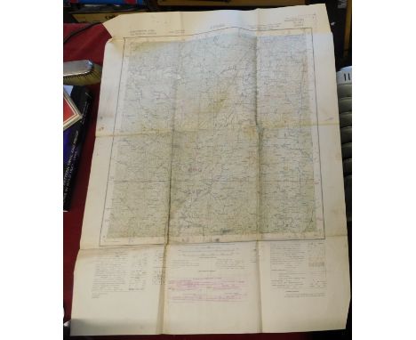
![[TUCKER (Benjamin)] The Report of the Surveyor-General of the Duchy of Cornwall ... the Islands of Scilly, 1810, 8vo, 2 foldi](https://cdn.globalauctionplatform.com/494d6759-0c1f-48a2-b349-b1f7009a63a2/ccc0b342-1a93-493d-a678-b1f900ab03e2/468x382.jpg)
Lot 136
Surveying. LEYBOURN (William) The Compleat Surveyor, 5th edition 1722, small folio, frontis portrait, title in red and black, folding diagrammatic plates, some general age toning, library stamps to title and some plates, panel calf with good reback; KENT (Nathaniel) Hints to Gentlemen of Landed Property, 2nd edition 1776, 8vo, 10 folding plates, calf, front joint cracked; DAVIS (W) A Complete Treatise on Land Surveying, 4th edition, 1805, uncut, folding plates, modern half morocco; PARNELL (Sir H) A Treatise on Roads, 1833, 8vo, 7 folding plates, very light foxing, later half calf; JOHNSTONE (J) An Account of the Mode of Draining Land, 3rd edition, 1808, 8vo, uncut, 19 folding plates, light foxing, modern calf backed boards
Lot 156
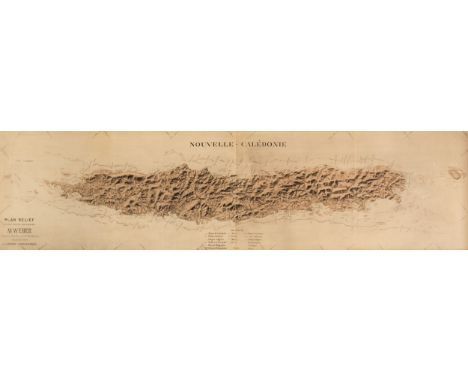
* New Caledonia. Weber (Mr., surveyor), Nouvelle Calédonie, Plan Relief dressé sous la direction de Mr Weber, Capitaine Adjt. Major d'Infie. de Marine d'apres les travaux de la Mission Topographique, circa 1880, tint stone lithographic map with table of explanation, old folds, some creasing and dust soiling, 265 x 150 mm, framed and glazedQTY: (1)NOTE:New Caledonia was discovered by Captain James Cook in 1784, but annexed by France in 1853. It is a dependency of France but is not part of French Polynesia. The map is supplied with a letter dated the 17th of September 1930 from the Travellers Club in Pall Mall, giving the map's provenance.

Lot 145
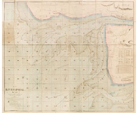
Lancashire. Hennet (G.). A Map of the County Palatine of Lancaster Divided into Hundreds and Parishes from an accurate survey made in the years 1828 and 1829, Henry Teesdale and Co. May 1st. 1830, large-scale engraved map with bright contemporary wash colouring, sectionalised and laid on linen, calligraphic cartouche, compass rose, table of explanation, uncoloured vignette of the New Custom House Liverpool, slight offsetting, edged in green silk, marbled endpapers, 1615 x 1130 mm, contained in a contemporary marbled calf book box with contrasting red morocco gilt label to the spine, some wear to extremities, together with Liverpool. Walker (J & C), Liverpool Bay surveyed by the Marine Surveyor of the Mersey Docks and Harbour Board, 1866. Corrected to 1880. Scale of two nautic miles, large engraved sea chart with contemporary outline colouring, sectionalised and laid on linen, manuscript reticulation into a grid of 127 squares, 1225 x 1415 mm, marbled endpapers, contained in a morocco gilt slipcase, worn and rubbed at the extremities, with Ordnance Survey (publishers). Liverpool and its Environs, 1850, uncoloured engraved map on a scale of six inches to the mile, sectionalised and laid on linen, slight dust soiling and staining, cloth endpapers, 980 x 1270 mm, contained in a near-contemporary slipcase but with a 'Bowles's England by Paterson' on the spine, slipcase split and rubbed, plus George Philip & Son (publishers). Philip's Trigonometrical Plan of the Town & Port of Liverpool from Actual Survey, 1858, large lithographic map with bright contemporary wash colouring, on two sheets, sectionalised and laid on linen, calligraphic title, compass rose and table of the wards, occasional small holes where old folds cross, slight dust soiling and offsetting, left-hand sheet 1100 x 1380 mm, right-hand sheet 1300 x 1380 mm, edged in green silk, marbled endpapers, bound in contemporary morocco gilt boards, heavily worn and rubbed, bound size 250 x 290 mmQTY: (4)
Lot 150
Liverpool. Walker (J & C, publisher), Liverpool Bay surveyed by the Marine Surveyor of the Mersey Docks and Harbour Board, 1874 corrected to October 1875, scale of two nautic miles, large folding engraved sea chart with contemporary wash colouring, sectionalised and laid on linen, neat manuscript reticulation in red ink, some areas of light toning, 1250 x 1490 mm, marbled endpapers, bound into half calf gilt boards, together with Philip (George & Son). Philips' Plan of the Town & Port of Liverpool with Birkenhead and the adjoining Cheshire Coast, circa 1860, folding engraved map with contemporary wash colouring, sectionalised and laid on linen, 625 x 715 mm bound into red gilt buckram boards, with Philip (George & Son). Philips' Plan of Liverpool and the Adjoining Cheshire Coast compiled by actual surveys, uncoloured folding engraved map, sectionalised and laid on linen, bound into green buckram boards with publishers' printed guide to the city, 800 x 1200 mm, plus Eyres (Charles, publisher). A Plan of the Town & Township of Liverpool from an actual survey taken in the year 1785 [but mid 19th-century], uncoloured lithographic map, sectionalised and laid on linen, originally engraved by Thomas Conder, decorative cartouche incorporating panorama of Liverpool, slight staining, 535 x 875 mm, marbled endpaper, publisher's blind-stamped gilt cloth boards, remains of silk tie, upper board detached, rubbed and worn, with another late 19th-century plan of Liverpool similar QTY: (5)
-
1529 item(s)/page