We found 1529 price guide item(s) matching your search
There are 1529 lots that match your search criteria. Subscribe now to get instant access to the full price guide service.
Click here to subscribe- List
- Grid
-
1529 item(s)/page


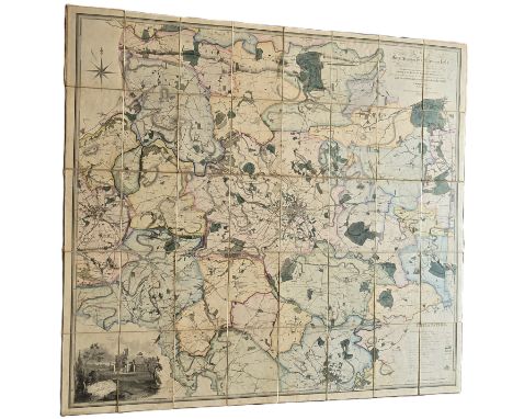
Lot 446
A "LEEDS" Martins large scale map. Circa 1831 with original slip binder. A large folding Map, linen backed and coloured on a scale of approximately 2 3/4 inches to 1 mile. Extending unfolded to 49 x 46 inches. Calligraphic title, compass rose, table of explanation and a vignette of the west end of Kirkstall Abbey. The whole edged in green silk. Folded into the original slip container A map of the country extending ten miles round Leeds, showing all the parish and township boundaries. Taken from actual admeasurements in the years 1918, 20 and 21 by Joshua Thorp and subsequently re-surveyed and corrected to January 1st 1831 by S.D.Martin, surveyor. Published Leeds, John Bains and company. Map in good condition. Slip container having some deterioration.
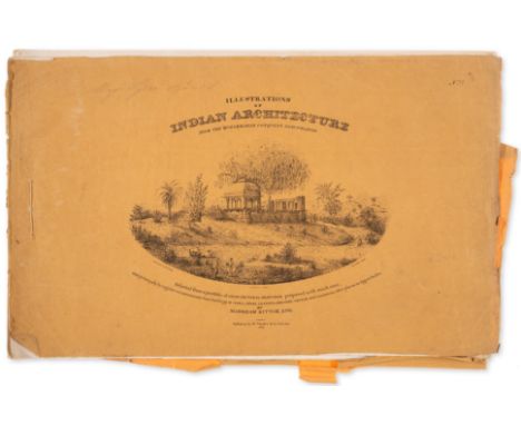
Lot 496
India.- Architecture.- Kittoe (Markham) Illustrations of Indian Architecture from the Muhammadan Conquest Downwards, Parts 1-10 only (of 17), complete with 41 lithographed plates and all text ff. called for, some spotting or staining and marginal creasing, some light browning, original lithographed pictorial wrappers, part 9 lacking wrappers, parts 2, 8, & 10 lacking upper wrapper, some tears and staining, and creasing, [RIBA 1677], Calcutta, Thacker & Co., 1838; and 5 other miscellaneous plates and 2 text ff. from the work, oblong folio *** Rare first work on the Islamic architecture of India. We locate only three other sets at auction (2009 and 2010, both defective, and 1919, for which we have no statement of completeness). Kittoe (1808-1853) was a pioneer of Indian archaeology, and was appointed Archaeological Surveyor to the Government of India in 1846. Most of the sites documented are in Uttar Pradesh.
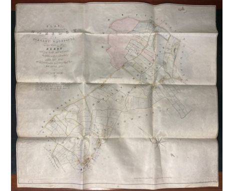
Lot 273
Manuscript Map. Ink and wash coalfield map on vellum: Plan of lands in the townships of Horsley and Horsley Woodhouse in Derby, belonging to the Rev H W Stilwell. The coal which is leased to John Ray Esq, except coal under lands marked by a red dotted line and coloured yellow. 64 x74 cm approx, by J Clarke, land agents and surveyors, Higham Cliff, 1861; + May (T H) (land and mineral surveyor): Plan of the coalworks at Kilburn Colliery under the estate of the Smalley School trustees, hand drawn, wash colouring, linen backed, approx. 37 x 98 cm, 1898. (2)
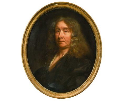
Lot 174
John Riley (English, 1646-1691) William Chiffinch (c.1602–1691), Master of the Wardrobe to Charles II oil on canvas 60 x 50cm Provenance: Sotheby's, London, British Paintings, 17th July 1985, Lot 506, as 'Portrait of a gentleman' by John Riley William Chiffinch was an indispensable figure to Charles II, holding a number of offices at court, including Surveyor of the King’s Pictures, Keeper of the King’s Jewels and Master of the Hawks. He was also renowned for his mastery of intrigue and was involved in many court plots and matters pertaining to the King’s mistresses. He continued his roles within the royal household under James II but fell out of favour after the Glorious Revolution due to suspicions of Jacobitism. Indeed, his daughter Barbara was to become an active Jacobite.Another version of the present composition is in the Dulwich Picture Gallery (DPG568). The painting is executed in oil on a canvas support which has been lined. Lining has secured old damages present in the lower half of the picture. The canvas tension is good and the picture is in plane. The paint layers are stable and secure but have suffered from wear and abrasion visible in the darker paint passages. The old repairs in the lower half have been filled and retouched – the fill is slightly lumpy and the overpaint discoloured and matte, although covered by the varnish layers. The varnish is glossy, thick and fairly even.
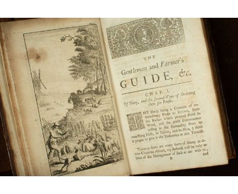
Lot 21
Farming Interest to include: Bradley (R) The Gentleman and Farmer's Guide for the Increase and Improvement of Cattle ... also, The best Manner of Breeding, and Breaking Horses both for Sport & Burden ..., London: Printed by J. Applebee for W. Mears, 1729, 8vo, 19th century calf with raised bands, title in black and red, four engraved plates and multiple vignettes; Wyld (Samuel) The Practical Surveyor, or, the Art of Land-Measuring made Easy ... To which is added an Appendix, Shewing how to Draw Buidlings, & c. in Perspective ..., London: Printed for H. Lintot, [1730s], 8vo, Second Edition, 19th century calf with raised bands, fold-out engraved frontispiece, 6 fold-out plates, tables; Burdon (Captain) The Gentleman's Pocket-Farrier ... with Large Additions and Remarks by Dr. Henry Bracken of Lancaster, London: Printed for W. Johnston, 1748, 19th century mottled calf, 16mo, Fourth Edition (3)Ombersley Court, Worcestershire
Lot 1131
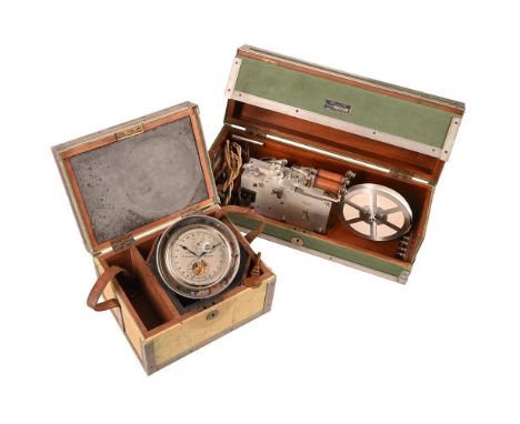
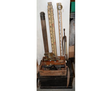
A RARE TWO-DAY ORDINANCE SURVEY CHRONOMETERTHOMAS MERCER, ST. ALBANS, MODEL S. C. 2, CIRCA 1949The circular four pillar single chain fusee movement with Harrison's maintaining power, jewelled pivots for the escape and seconds wheels, Earnshaw type spring detent escapement regulated by split bimetallic balance with cylindrical compensating weights, helical palladium balance spring and jewelled endstone, the spotted backplate with spring set-up ratchet and blued-steel pillar and backcock securing screws, the 4 inch circular silvered Arabic numeral twenty-four hour 'sidereal' dial with subsidiary seconds dial incorporating open centre revealing ratchet-tooth wheel for opening and closing electrical contacts with the beat of the escapement at six o'clock, within annotation in red CAUTION: HANDS, FORWARD ONLY below signature THOMAS MERCER LTD, ST. ALBANS, ENGLAND across the centre and DOWN/UP, 0-56 power reserve dial numbered 18384 beneath twelve o'clock, with blued steel spade hands and red Arabic five minutes beyond the outer minute track, set beneath a screw-down chrome-plated bevel-glazed bezel incorporating dust-cap sealed winding square aperture to glass, mounted onto a disc collar stamped 18384 to underside incorporating START/STOP lever and insulated electrical contact screws engaging with sprung contact posts fitted to the exterior of the grey-speckle japanned cylindrical aluminium case, complete with typsy winding and hand setting keys, rating certificate dated 22nd March, 1949 and Mercer information sheet C 6/61, set in a metal angle reinforced baize-lined canvas covered field case hand-inscribed O.S. 821 A over M.O.D. arrow device to the lid and fitted with leather carry strap; with a ticker-tape recording chronograph, Thomas Mercer, model T. P. A., mid 20th century, the rectangular thick-gauge brushed aluminium box-type frame incorporating brass bushed pivots for the single going barrel movement regulated by an adjustable centrifugal governor, driving a milled aluminium wheel positioned beneath a tensioned jockey wheel to pull through ticker tape fed via a large spool across the top plate, past a pair of solenoids each independently operating a pivoted armature fitted with sharp 'pricker' to mark the ticker tape as it passes beneath, the front with WIND square, 2 SPEEDS, IN FAST and OUT SLOW selection plunger, ON/OFF lever and inscribed MERCER, ST. ALBANS. ENGLAND to centre over number 185 to lower right-hand corner, secured in its original mahogany-framed drop-front box with electrical feeds from paired external contact plugs labelled BATTERY, KEY and CHRONOMETER positioned on the right-hand end, the exterior lined in green painted canvas and with metal reinforced angles, the top indistinctly hand-inscribed W10/W 0002 over M.O.D. arrow device, the front with printed metal plate MERCER, MODEL T. P. A. / 2, MADE BY THOMAS MERCER LTD. ST. ALBANS. ENGLAND, with chrome winding key, contact feed cables, and Mercer information sheet C 7/61, (2).The chronometer case 17cm (6.75ins) high, 28cm (11ins) wide, 21cm (8.25ins) deep; the ticker-tape chronograph case 19.5cm (7.75ins) high, 49cm (19.25ins) wide, 17.5cm (7ins) deep. The chronometer making firm Thomas Mercer of St. Albans was established by Thomas Mercer (1822-60) at North Road, London in 1858 before moving to 45 Spencer Street, Clerkenwell in 1860. Mercer became an active member of the British Horological Institute (established in 1858) where he lectured on the need to modernise the industry and served as honorary treasurer from 1875-95. After occupying several addresses in Clerkenwell Mercer relocated the core of the business to St. Albans in 1874 setting up a factory behind his house at 14-15 Prospect Road. Although the bulk of the businesses work was undertaken in St. Albans Mercer personally made weekly trips to Clerkenwell to deliver/collect parts finished by specialist outworkers as well as visit the Horological Institute. In order to maintain a presence in London Thomas Mercer opened an outlet 18 Westmoreland Road, City Road in 1890. Succuss at the Greenwich trials was also always considered important to Mercer who entered instruments every year; he was placed second in 1881 and his son, Frank, came first in 1911. In 1900 Thomas Mercer accepted an invitation to judge at the Universal Exhibition in Paris but unfortunately caught a cold on the ferry crossing and died soon after his return. The business was subsequently continued by his successors becoming of the most prolific suppliers of chronometers and other timepiece for industrial, maritime and domestic purposes and continued trading in St Albans until 1984. The current chronometer was developed by Mercer for surveying purposes. Fitted with electrical contacts and rated to sidereal time the timepiece is designed to be used in conjunction with the ticker-tape chronograph and an Admiralty pattern 45 degree prismatic Astrolabe or theodolite (to allow accurate measurement of angular distance, or 'zenith distance' between a given star and the zenith). The very accurate timing of the zenith distance of a given star can provide precise 'local time', and, through comparison with Greenwich meantime, allow accurate longitude and latitude of the observer to be established.In practice, once the apparatus has been set-up, the seconds beats of the marine chronometer (synchronised with Greenwich meantime) will be recorded on the ticker tape at up to 1 inch intervals (depending-on the speed setting of the paper feed) through electrical connection to one of the solenoid-operated prickers. The second pricker is connected to a hand-switch (or key) operated by the surveyor observing the star through a theodolite (or prismatic Astrolabe). At the moment the given star reaches its maximum (or chosen) zenith angle the surveyor presses the switch which records this moment, alongside the regular marks of the chronometer, on the ticker tape. By knowing the time at which the chronometer feed was activated the respective time of the star reaching its zenith can be established by simply counting the pricks (for each second) up to the point of the mark created by the observation. Indeed, by taking a ruler and measuring the distance the observed mark occurs between two marks created by the chronometer feed, the time of the mark (in relation to Greenwich meantime) can be ascertained up to an accuracy of around one twentieth of a second.In order to create accurate maps, a location within 50 feet would need to be obtained; this corresponds to a timed observation within 0.03 of a second. With this in mind several observations would need to be taken and any errors in the rate of the chronometer ascertained and corrections factored-in before suitably accurate readings for location can be established. In practice the rate chronometer was often independently checked in the field (both before and after the observations) through comparison with against radio Time Signals transmitted from Greenwich. Markings to the lid of the chronometer box indicates that it was owned by the Ordinance Survey. As such it was likely to have been used alongside aerial photography for small scale maps, particularly in undeveloped or difficult locations, where the location data is governed by a series of points whose positions are fixed by radio Astro Observations.
Lot 45
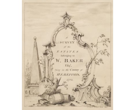
Herefordshire - Estate Survey. A Survey of the Estates belonging to W. Baker Esqr., lying in the County of Hereford, 1782, fine decorative pen and ink title on vellum signed by William Chapman of Watlington, Oxfordshire, 9 finely drawn plans on vellum in pen, ink and watercolour (including 5 folding), each plan detailing names of farms, fields, woodlands and orchards etc. and with owner names of neighbouring properties, interleaved with 13 leaves of lists and tables written in a neat calligraphic hand on laid paper providing information regarding tenants names, acreages of land (arable, meadow, pasture and coppice), pencil annotation to front flyleaf 'From Ledbury Park sale of Lord Biddulph', marbled endpapers, contemporary calf, gilt decorated spine, elaborate gilt roll border to boards and gilt decorated roundel to centre of upper board bearing title 'Herefordshire Estates', joints cracked and light wear to extremities, large folio (54 x 37 cm), with lithograph map of Ledbury loosely insertedQTY: (1)NOTE:A beautifully executed estate survey by William Chapman of Watlington, Oxfordshire. We have located an entry in the Oxford Journal for Saturday 30th June 1759 listing the skills of William Chapman of Watlington, Oxfordshire, 'Noblemens and Gentlemens Estates are carefully surveyed and plotted in the modern manner, and books of the particulars drawn therefrom, by William Chapman, Land-Surveyor, at Watlington, Oxfordshire. A specimen of his fair plans may be seen at Mr. Thomas Cooper's...'. The National Archives catalogue records an entry for the 'Will of William Chapman, Painter of Watlington, Oxfordshire' dated 18th March 1782.The whole estate acreage in this survey totalled over 1224 acres and the plans of the farms comprise 1. Hazle Farm in the parish of Ledbury; 2. Siddington Farm in the parish of Ledbury; 3. Hall House, Eybridge, part of Whild House and Hill Field Farms in the parish of Ledbury; 4. Noad Farm, and part of Hill Field Farm in the parish of Ledbury; 5. Whild House Farm in the parish of Ledbury; 6. Heath Farm in the parishes of Bromsborough and Dimmock; 7. Bullen Estate in the parish of Ledbury; 8. Vineyard, Camp and Lawn House Farms, with the late Ann Poston's in the parishes of Ledbury and Donnington; 9. Stocking Farm in the parish of Donnington; 10. Wool-pits Farm and Wood, in the parish of Ledbury.
Lot 110
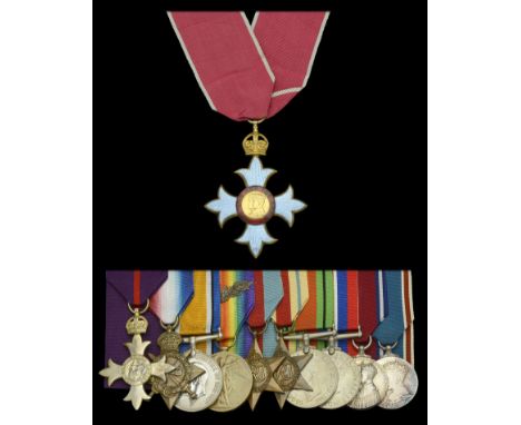
A Second War ‘Civil Division’ C.B.E., Great War ‘Military Division’ O.B.E. group of eleven awarded to Lieutenant-Colonel A. C. Willmot, 4th Battalion, King’s African Rifles (Uganda Rifles), who served during the inter-War years as Director of Public Works, Uganda The Most Excellent Order of the British Empire, C.B.E. (Civil) Commander’s 2nd type neck badge, silver-gilt and enamel, with neck riband, suspension ring detached from crown but present; The Most Excellent Order of the British Empire, M.B.E. (Military) Member’s 1st type breast badge, silver-gilt, hallmarks for London 1919; 1914-15 Star (Lieut. A. C. Willmot. Uganda T.C.); British War and Victory Medals, with M.I.D. oak leaves (Capt. A. C. Willmot); 1939-45 Star; Africa Star; Defence and War Medals 1939-45; Jubilee 1935, unnamed as issued; Coronation 1937, unnamed as issued, mounted court-style for display, good very fine (11) £700-£900 --- C.B.E. (Civil) London Gazette 1941: Captain Arthur Charles Willmot, O.B.E., Director of Public Works, Uganda. O.B.E. (Military) London Gazette 3 June 1919. M.I.D. London Gazette 11 June 1920 (East Africa). Arthur Charles Willmot was born on 21 July 1881 and was educated at Lancing College, Sussex, and Aspatia Agricultural College, Cumberland. He was appointed Assistant Surveyor, Uganda Protectorate, in 1907, and District Engineer, Public Works Department, the following year. In 1913 he was appointed Engineer-in-Charge of the construction of the Kampala to Port Bell Railway. Following the outbreak of the Great War he was commissioned temporary Lieutenant in the Uganda Transport Corps and served during the Great War in the East African campaign from 15 December 1914. Transferring to the 4th Battalion, King’s African Rifles (Uganda Rifles) on 26 May 1915, he was promoted temporary Captain on 1 November 1916, and was appointed Adjutant of the 4th Battalion, King’s African Rifles on 9 January 1917. For his services during the Great War was Mentioned in Despatches and was appointed an Officer of the Order of the British Empire. Relinquishing his commission on 28 April 1919, Willmot remained in Uganda and was appointed Deputy Director of Public Works in June 1923, being promoted to Director of Public Works ten years later. Awarded both the 1935 Jubilee Medal and the 1937 Coronation Medal for his services as Director of Public Works he was appointed a Commander in the Civil Division of the Order of the British Empire in the 1941 New Year’s Honours’ List. He saw further service once more with the 4th Battalion, King’s African Rifles, during the Second World War, serving as Controller of Works and Transport in Eritrea, and was advanced to the rank of Lieutenant-Colonel. Settling in Kenya following the Second World War, he died in 1953.
Lot 2
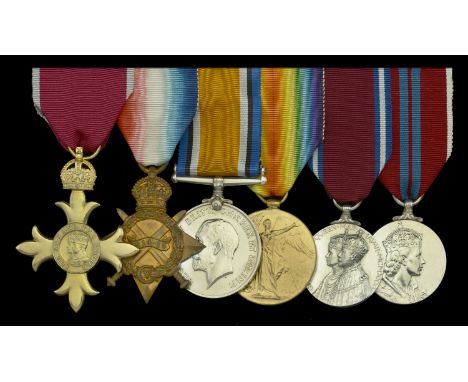
A post-War ‘Civil Division’ O.B.E. group of six awarded to Captain H. S. Ganderton, Devonshire (Fortress) Company, Royal Engineers, later County Surveyor of Wiltshire The Most Excellent Order of the British Empire, O.B.E. (Civil) Officer’s 2nd type breast badge, silver-gilt; 1914-15 Star (Capt. H. S. Ganderton. R.E.); British War and Victory Medals (Capt. H. S. Ganderton.); Jubilee 1935, unnamed as issued; Coronation 1953, unnamed as issued, mounted for wear, with crushed named card boxes of issue for the Great War awards, nearly extremely fine (6) £240-£280 --- O.B.E. (Civil) London Gazette 1 January 1949: Howard Sims Ganderton Esq., County Surveyor of Wiltshire. Howard Sims Ganderton was born at Aston, Birmingham, in 1890. A Surveyor employed by Torquay Borough Council, he was commissioned Second Lieutenant in the Devonshire (Fortress) Engineers, Works Companies, Royal Engineers on 1 February 1912, and was mobilised for War service in the 1/3 Devon Army Troops Company, Royal Engineers at Torquay on 4 August 1914 and was appointed Acting Captain. He embarked for the Mediterranean Expeditionary Force on 17 October 1915 and was employed on construction work at Imbros and Mudros. He embarked at Mudros for Alexandria on 31 January 1916, and served as Officer in Charge, 1/3 Devon Army Troops Company, Royal Engineers, Warden Saw Mills, Camp A, North Alexandria from 16 March 1916. With the designation of unit altered to 569th (Devon) Army Troops Company, Royal Engineers, he moved to Rafa, Palestine, on 31 October 1917 and was employed on construction work there, moving finally to Beirut on 25 October 1918. Disembodied on 30 September 1921, he relinquished his commission, retaining the rank of captain. Subsequently successively appointed Assistant County Surveyor Cornwall, Assistant County Surveyor Wiltshire, and County Surveyor Wiltshire in 1927, he was awarded the Silver Jubilee Medal in 1935, and the Coronation Medal in 1953. Appointed as an Officer of the Order of the British Empire in 1949, ‘in recognition of his work during the Second World War’, he retired as County Surveyor, Wiltshire County Council, in March 1954, and died at Bradford-on-Avon on 29 September 1954, aged 63. Sold with a photographic image of the recipient; and copied research.
Lot 324
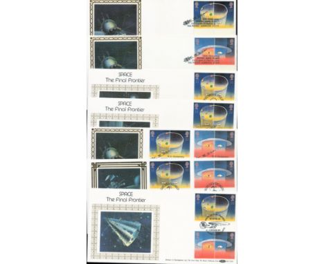
Space 1991 Benham Collection of seven official Europe in Space FDS BLCS46, Yuri Gagarin 30th ann, BLCS64b 25th ann Surveyor 1 Space Mission plus 5 scarce booklets FDCs. Assorted special official postmarks. Good condition. All autographs come with a Certificate of Authenticity. We combine postage on multiple winning lots and can ship worldwide. UK postage from £5.99, EU from £7.99, Rest of World from £9.99
Lot 102
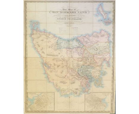
Australia - Tasmania.Frankland (George), This Map of Van Dieman’s Land is Dedicated to the Land Holders of the Colony by Their Faithful Servant George Franklin, Surveyor General and Sole Commissioner of Crown Lands.Engraved and published by J. Cross, March 1st, 1839, engraved hand-coloured folding map, 128cm x 82.5cm, inset plans of Launceston and Hobart Town, 40 sections mounted on linen, inner cover with the name ‘F. F. Whitfield, 1842’, original slipcase with worn paper label. [Tooley: Tasmania 230][In 1848, F.F. Whitfield was recipient of expenses in Hobart as a Medical Witness and in 1857, as an inhabitant of the district of Longford, countersigned a public letter supporting the Ministry of the Colony.]
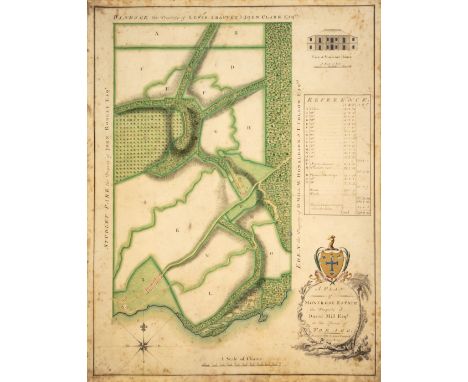
Lot 46
Tobago.- Cotton plantation.- Campbell (James, Colony Surveyor of Grenada and Tobago, 1736-1805) A Plan of Montrose Estate, the Property of David Mill Esqr. in the Island of Tobago, vignette with the façade of Montrose House in the upper right corner, title cartouche and compass rose, boundary information with landowner information to the east, weat and north of the estate, reference key with land use information including identification of 'Negroe Grounds' in the centre right', pen and ink, watercolour and gouache on vellum, sheet 645 x 502 mm (25 1/2 x 19 3/4 in), scattered spotting and surface dirt, unframed, 1777*** [David Mill was an] early purchaser of land in Tobago, [... and] was among the inhabitants of Tobago who were signatories of the petition to Robert Melvill in 1767 and the address to Lt Governor Ferguson in 1781 [...] In 1777 David Mills [sic] contracted to supply 60,000 pounds of cotton to Thomas Cotton of Tobago and two groups of metropolitan merchants, one in Manchester and one in London. [see Centre for the Study of the Legacies of British Slavery, UCL: https://www.ucl.ac.uk/lbs/person/view/2146632462]
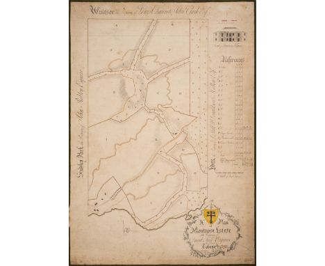
Lot 47
Tobago.- Cotton plantation.- Campbell (James, Colony Surveyor of Grenada and Tobago, 1736-1805) A Plan of Montrose Estate, the Property of David Mill Esqr. in the Island of Tobago, with vignette with the façade of Montrose House in the upper right corner, title cartouche and [?] partial compass rose, boundary information with landowner information to the east, weat and north of the estate, reference key with land use information including identification of 'Negroe Grounds' in the centre right', pen and ink, watercolour and gouache on laid paper, edged with green silk, sheet 675 x 480 mm (26 5/8 x 18 7/8 in), laid onto linen support, silk edging coming away in places, scattered spotting and surface dirt, unframed, 1777*** Variant to the previous lot, with the present plan executed on paper rather than vellum.

Lot 141
MEDAL PAIR - Waterloo and Military General Service - Lieutenant Robert John Uniacke, 7th (Queen's Own) Hussars. Waterloo Medal, fitted with replaced hinged straight bar suspension; and Military General Service 1793-1814, 1 clasp, 'Orthes', both renamed in Sans Serif lettering to "LIEUT. ROBERT UNIACKE, 7TH REGIMENT HUSSARS".Sold together with a letter from Major J.S. Sutherland MBE (Queen's Own Hussars Headquarters), 16th February 1965, in which Major Sutherland confirms Uniacke's entitlement for the Waterloo Medal and the General Service Medal with clasp. He fought at Waterloo and in the Peninsular and was stated to have been a 'most gallant officer'. Provenance:Private Collection Footnote:Lieutenant Uniacke was a member of a famous and wealthy Irish Protestant family who owned the Woodhouse Estate at Stradbally, County, Waterford. Described as a ‘most gallant officer’ in Army records, he was made a cornet on January 25, 1812, Lieutenant on July 15, 1813 and retired from the Army on July 24, 1817. In 1821, he married Lady Mildred Bourke, sister to Robert, 5th Earl of Mayo, with whom he had six children. The couple’s only surviving son and heir, Colonel Robert Bor Uniacke died in 1853, aged 29.A justice of the peace and deputy lieutenant, Lieutenant Uniacke inherited the estate in 1802 as the eldest son of Colonel Robert Uniacke (1756-1802) and Annette Constantia. He died aged 55 in Clifton, near Bristol in April 1851, where the family had a home. Lieutenant Uniacke’s father was a Member of Parliament for the city of Youghal as well as being a Colonel of Waterford Militia and Surveyor General of the Ordnance. His mother was the daughter of John Beresford, the First Commissioner of the Revenue of Ireland, whose brother, George, was the 1st Marquis of Waterford.John James Fitzgerald (1797–1825), Lieutenant Uniacke’s younger brother, sailed as chaplain on a convict ship in 1823 to Australia, where he became the chronicler of John Oxley’s geographical expedition in search of the sources of the river later called Brisbane. In 1824, he was appointed surveyor of distilleries as well as Sheriff and Provost Marshal of New South Wales. He died of remittent bilious fever in Sidney in 1825, aged 27. Other members of the Uniacke family also have early connections to Nova Scotia, Canada.The Uniackes of Woodhouse were staunch Protestants. They built St James’ Church between 1798 and 1802, a school for protestant children just outside the gates of the churchyard and another school for children of both Protestant and Catholic denominations where Lieutenant Uniacke’s sister and daughter both worked as teachers. When the Great Famine hit Ireland, Lieutenant Uniacke crossed religious borders to work closely with Catholic medical doctor, Dr John Coghlan of Kilmacthomas to build a Work House, which he helped finance himself and became a key member of the Board of Guardians. The relationship was said to be quite unusual for the time.
Lot 275
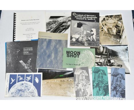
TWO FOLDERS OF SPACE RELATED BOOKLETS AND PHOTOGRAPHS, comprising 'Analysis of Surveyor 3 material and photographs returned by Apollo 12' published by NASA 1972, three Surveyor Launch Handbooks relating to Surveyor 3, 5 and 7 published by the Hughes Aircraft Company, a Boeing Aerospace publication 'Robotic Lunar Surface Operations' published 1990, two photographs stamped InfoSpace verso depicting a view of a rock rimmed crater and an illustration of the Surveyor craft, a Hughes Aircraft Company photograph of their Space Environmental Laboratory test facility, an unmarked photograph of the moon surface, a NASA publication 'The View From Ranger' published 1966, a Jet Propulsion Laboratory publication 'Ranger 1964' published 1964, an InfoSpace pamphlet 'Moon Shot' published 1964 and a pamphlet published by the United States Department of the Interior Geological Survey' published 1970
Lot 252
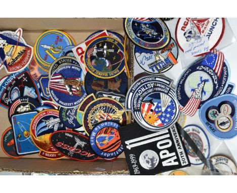
A BOX OF MOSTLY AMERICAN SPACE MISSION RELATED CLOTH BADGES, to include Space Lab 2, Space Lab 3, Gemini II, Apollo 11 30th anniversary, Columbia crew badge, Mars Pathfinder, Mars Surveyor, Hubble Space Telescope, Apollo XII, Apollo XIII, Russian cloth badges and space related stickers, approximately eighty badges
Lot 149
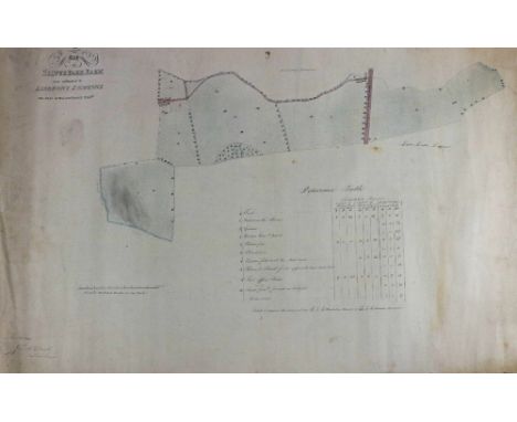
* Hackney (Thos.). Thomas Clarke's Patent Steam Excavating Machine, circa 1850, pen and watercolour side and general elevation of a track born excavator, some dust soiling, slight fraying and occasional small closed tears to the margins, 535 x 730 mm, together with Hows Truss Bridge, circa 1880, pen and ink side elevation of a bridge, with insets of the bill for timber and iron, and side and bottom views of the chord, slight marginal fraying, 335 x 750 mm, with Wadsworth (George, Chief Engineer). Plan of Draw-Bridge Designed for the Coosa River, Dalton & Jacksonville Rail Road 1st September 1859, pen and ink side elevation on three conjoined sheets, some marginal closed tears, margins torn and repaired on verso, 245 x 1630 mm, plus Dawson (Robert, Captain R. E.). Plan of Certain Lands subject to Tithe in the Township of South Holme in the Parish of Hovingham in the County of York, by Tuke and Allanson, 1839, large pen and ink estate plan laid on linen, five sheets of vellum deeds attached to the left-hand margin, some dust soiling, margins frayed with occasional closed tears, 650 x 1250 mm, and Bradley (James, Surveyor). Map of a Farm at Croxton in the Occupation of Mr C. Marris, 1832 pen and watercolour estate plan, with a manuscript list of 'parcels of land' on a separate piece of paper attached to lower right corner, slight creasing, 755 x 475 mm, with Telford (Thomas). Sketch of the Port of Cardiff shewing the Present State of Rivers and Canal and proposed Impovements (sic) 1821 (Signed) Thomas Telford, (early 20th-century copy), pen & ink map on canvass, sheet size 470 x 610 mm, with two other plans similarQTY: (7)
Lot 576
Modern Hasbro GI Joe group of figures (made in China) to include (1) painted head, plastic hands, wearing Part Vintage Palitoy American Green Beret outfit with accessories; (2) Similar, wearing Part Vintage Palitoy Engineer/Surveyor outfit with accessories; (3) Similar, wearing GI Joe combat outfit with accessories; (4) Similar, wearing Geyper Man Russian Infantry outfit with accessories, generally Good, not checked for completeness/correctness, loose/unboxed - see photos. (4)
![Manuscript Map: Irish, [Co. Louth] McMahon (Thom.) surveyor, Map and Survey of Several holdings at Killay in the Parish](https://cdn.globalauctionplatform.com/aec3df14-fc67-43ec-9ed4-b1a800ae5299/5dacefa8-6a3d-4b85-b619-b1ae00ab0dd9/468x382.jpg)
Lot 595
Manuscript Map: Irish, [Co. Louth] McMahon (Thom.) surveyor, Map and Survey of Several holdings at Killay in the Parish of Killay Barony of Ardee and County of Louth for the Right Honourable Sir A. John Foster, Bart., m/ss, hand coloured with key, approx. 50cms x 66cms (20" x 26") as a m/ss, w.a.f. (1)
Lot 599
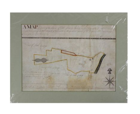
Manuscript Map, Irish (Co. Louth) Reading (Thomas) surveyor, A Map of Part of the Lands of Little Grange lying in the Barony of Fethard in County of Louth belonging to Mr. Mark Forward in the present Tenure of Mr. Byrnes & Mr. Armstrong, m/ss, hand coloured, with chart, surveyed April 1757, approx. 25cms x 35cms (10" x 14"),mounted as a map, w.a.f. (1)
Lot 171
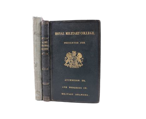
Surveying: Furnass (Rev. J.) The Practical Surveyor; being a Treatise on Surveying; designed for Schools, 8vo Newcastle 1809. Hf. title, fold. & other plans & maps, (hd. cold. in outline) text, illus., uncut, orig. boards. With paper slip 'With The Author's Compliments' tipped - in at front; also A Treatise on Practical Surveying and Topographical Plan Drawing, 8vo Lond. 1829, with 2 fold. plans, errata slip; Bound with, Burr (G.D.) A Short Essay on Sketching Ground without Instruments, Lond. 1830, text illus., & 6 fold. plts., a.e.g., in full green mor. gilt Prize Binding from Royal Military College. V. good. (2)
Lot 111
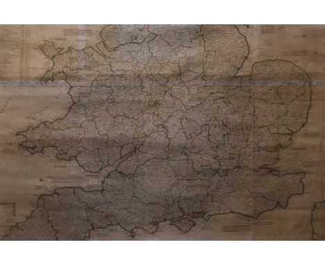
KITCHIN, Thomas. Very large map of England and Wales, 1794. A New Map of England and Wales, drawn from several surveys &c on the new projection corrected from Astronomical Observation and the places marked...The canals inserted to 1792 by J Phillips, surveyor. Published by Laurie & Whittle, 12th May 1794 12800mm x 1800 (50.5 inches by 43.5 inches). Hand coloured with vignette in top right hand corner. Framed and glazed.
Lot 148
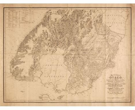
New Zealand. Spreat (W. W. J.). Map of the Province of Otago, Geographical Positions & Coast Lines principally by Captain J. L. Stokes R. N. Interior by J. T. Thomson, Chief Surveyor & Assistants Alex Garvie & J. McKerrow with Additions by J. Drummond, J. J. Coates & W. C. Wright, Mining Surveyors, Gold Fields Departments, including also the Explorations of Dr Hector, W. C. Rees, P. Q. Caples & W. Arthur, Compiled by Adam Rolland, Reduced & Drawn on Stone by W. W. J. Speat at the Survey Office, Dunedin, Otago, N. Z. J. T. Thomson Chief Surveyor, January 1866, uncoloured lithographic map laid on linen, old folds, some dust soiling, slight creasing, 610 x 800 mmQTY: (1)NOTE:An uncommmon map of the south tip of the South Island of New Zealand. Relief is shown by hachures and spot heights and includes cadastral information, gold fields, roads, distance tables, native reserves, heavy bush and accommodation houses.
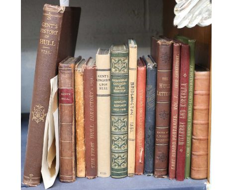
Lot 333
Hull and Other Yorkshire Books, including (Gent) Thomas, Annales Regioduni Hullini: or, the History of the Royal and Beautiful Town of Kingston-upon-Hull..., Ward and Chandler, 1735, plates, worn diced calf binding (rebacked); A Copy of the Poll...in the Town of Beverley, on Thursday the 8th Day of October, 1812..., Printed by B. Tate, calf backed marbled boards; Fac-Simile Reprint of the First Hull Directory, Published in 1791..., M. C. Peck and Son, 1885, cloth binding gilt; and 11 others, together with Bower (A., surveyor), Plan of the Town and Harbour of Kingston upon Hull, 1792, hand-coloured engraved map. (15)
Lot 52
A scarce post-War ‘Civil Division’ O.B.E. group of six awarded to Lieutenant-Colonel T. Steers, Royal Engineers and General List, a Chartered Surveyor who was one of the last non-combatant troops to leave the Canal Zone in December 1957 The Most Excellent Order of the British Empire, O.B.E. (Civil) Officer’s 2nd type breast badge, silver-gilt; 1939-45 Star; Burma Star; Defence and War Medals 1939-45, General Service 1918-62, 3 clasps, Palestine 1945-48, Near East, Canal Zone, unofficial retaining rod between first and second clasps, the third clasp loose on riband as issued (Major T. Steers. R.E.), the first five mounted as worn, the last loose, gilding slightly rubbed on first, minor edge bruise to GSM, good very fine (6) £200-£240 --- O.B.E. London Gazette 1 January 1958: Tom Steers, Esq., Senior Lands Officer, War Office. Tom Steers was born on 22 November 1912 and was educated at Elland Grammar School, before becoming a Professional Associate of the Chartered Surveyors’ Institution in 1937. He originally attested for the Royal Artillery in the ranks with enlistment number 973987 in 1939 and then transferred to the Royal Engineers 25 January 1941, before undertaking officer training with the 142nd O.C.T.U., based in Aldershot, on 19 February 1941. Commissioned Second Lieutenant on 10 August 1941, he was demobilised with the rank of honorary Major on 1 October 1946. Appointed on the staff of the Hirings Directorate, Middle East, as a Senior Valuation Officer, Steers was given a Senior Grade appointment in the War Department Lands Branch of the Civil Service and posted as Command land agent to Headquarters British Troops in Cairo, Egypt (B.T.E.), then transferred to Moarscar, near Ismallia. It was here he showed Andrew Nutting, Minister of State, around the new flats that had been built in the area. Re-commissioned Temporary Lieutenant-Colonel on 28 January 1952, Steers was responsible for the rundown in Egypt under the 1954 Anglo-Egyptian Agreement: this involving the relinquishing of over 500 building hirings and over 600 land hirings; the hand-over of nearly 40 installations to the Egyptian and Suez Base contractors, including finding accommodation for contractors and their families; and the disposal of surplus army camos, the proceeds from which realised nearly a million pounds. Relinquished his commission on completion of service, he was re-granted the honorary rank of Major, before being re-commissioned Lieutenant on 6 November 1956 to command the Claims and Hirings contingent during the Anglo-French occupation of Port Said. Finally relinquished his commission on completion of service 31 December 1956 he was re-granted the honorary rank of Major. Steers then remained in Egypt in a Civilian capacity as a Senior Lands Officer in the War Office, finally leaving Egypt on 21 December 1957, being granted a scarce O.B.E. from the War Office for this department. He died in Worthing, Sussex, on 11 October 1998.
Lot 407
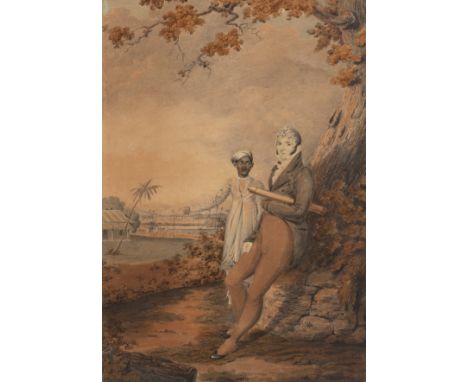
J.F. de Caselli (?)Portrait of a surveyor with Indian attendant in a landscape, signed and dated 1812, watercolour, 42 x 29cmFrom the Estate of Francis and Larissa Haskell. Francis Haskell (1928-2000) was an art historian, author and professor of Art History at the University of Oxford. His wife Larissa (1931-2024) was a noted Russian art historian, and was curator of Venetian drawings at the Hermitage.
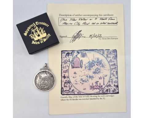
Lot 110
Wreck Coin: A Mexico (Spanish colony) Philp V 1740 silver 8 Reales (or Pillar Dollar), obv. crowned arms shield, rev. crowned globes flanked by crowned pillars with banner, Mexico mint, mounted within a hallmarked sterling silver pendant mount. The Dutch East Indiaman Hollandia struck on the Gunner Rock in Broad Sound off St.Agnes, Isle Scilly in the early hours of 13th July 1743 sinking in deep open water. Provenance: Sold with a certificate of authenticity signed by the dive surveyor.
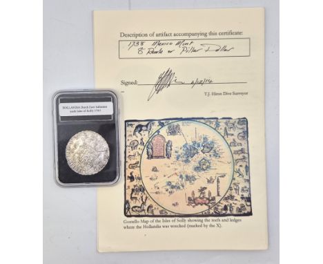
Lot 109
Wreck Coin: a Mexico (Spanish colony) Philip V 1738 8 Reales (or Pillar Dollar), obv. crowned arms shield, rev. crowned globes flanked by crowned pillars with banner, Mexico mint. The Dutch East Indiaman Hollandia struck on the Gunner Rock in Broad Sound off St.Agnes, Isle Scilly in the early hours of 13th July 1743 sinking in deep open water. Provenance: Sold with a certificate of authenticity signed by the dive surveyor.
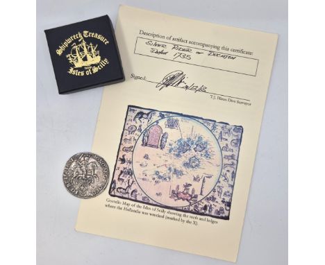
Lot 113
Wreck Coin: A Netherlands 1735 Ducaton (or silver Rider), obv. Rider brandishing sword in right arm, rev. crowned shields with arms of united provinces supported by two lions. The Dutch East Indiaman Hollandia struck on the Gunner Rock in Broad Sound off St.Agnes, Isle Scilly in the early hours of 13th July 1743 sinking in deep open water. Provenance: Sold with a certificate of authenticity signed by the dive surveyor.
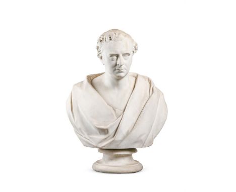
Lot 391
EDWARD WILLIAM WYON (1811-1885), A MARBLE BUST PORTRAIT OF ROBERT STEPHENSON M.P. (1781-1848) DATED 1855 Signed, dated and titled to reverse 78cm high Robert Stephenson was the only son of George Stephenson, the "Father of Railways", he worked alongside his father developing the designs and mechanical processes that produced the first steam locomotives. An engineer, surveyor and bridge builder, he became Member of Parliament for Whitby. This bust was originally housed at Euston Station and was transferred to the Clapham Railway Museum when the station was re-developed. It was then purchased by sealed tender in the mid-1960's and subsequently held in a private collection. Wyon seems to have created at least two versions of this portrait with another example from 1856 now held in the Institution of Mechanical Engineers. It was obviously a popular subject and a bronze version was also cast - with an example now held in the Science Museum. Condition Report: With wear, marks, knocks and scratches as per age, handling, use, and cleaning. Some weathering with exposure leading to sugaring to forehead and nose. Rain streaking notably to sides of neck and reverse. Socle chips- black marks and some wear to rear top edge Please see additional images for visual references to condition which form part of this condition report. All lots are available for inspection and Condition Reports are available on request. However, all lots are of an age and type which means that they may not be in perfect condition and should be viewed by prospective bidders; please refer to Condition 6 of the Conditions of Business for Buyers. This is particularly true for garden related items. All lots are offered for sale "as viewed" and subject to the applicable Conditions of Business for Buyer's condition, which are set out in the sale catalogue and are available on request. Potential buyers should note that condition reports are matters of opinion only, they are non-exhaustive and based solely on what can be seen to the naked eye unless otherwise specified by the cataloguer. We must advise you that we are not professional restorers or conservators and we do not provide any guarantee or warranty as to a lot's condition. Accordingly, it is recommended that prospective buyers inspect lots or have their advisors do so and satisfy themselves as to condition and accuracy of description. If you have physically viewed an item for which you request a report, the condition report cannot be a reason for cancelling a sale. Buyers are reminded that liability for loss and damage transfers to the buyer from the fall of the hammer. Whilst the majority of lots will remain in their location until collected, we can accept no responsibility for any damage which may occur, even in the event of Dreweatts staff assisting carriers during collection.Condition Report Disclaimer
Lot 514
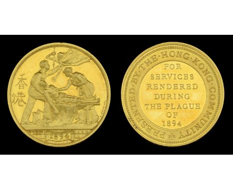
The rare Hong Kong Plague Medal in gold awarded to H. C. Nicolle Esq., Auditor of Hong Kong, who during the Plague of 1894 volunteered as a house-to-house visitor and was specially mentioned by the Permanent Committee of the Sanitary Board for his ‘splendid work, perseverance, and spirit of self-sacrifice’ Hong Kong Plague 1894, gold issue (H. C. Nicolle.) unmounted, in Wyon, London, fitted red leather case, small test mark to edge and minor edge nick, good extremely fine and rare £10,000-£14,000 --- Hilgrove Clement Nicolle was born at St. Helier, Jersey, on 19 July 1855, and was educated at Victoria College, Jersey. After a spell employed at the London and Westminster Bank in London, he joined the Foreign Office in February 1880, and was appointed an assistant auditor in Cyprus. He was advanced Auditor General of Cyprus in 1883, and was sometime Mayor of Nicosia. On 22 January 1890 he was appointed Auditor of Hong Kong, and soon after arrived in the Colony. The Hong Kong Plague 1894 A virulent epidemic of bubonic plague broke out in Hong Kong in early May 1894. Recognising the danger, the Governor, Sir William Robinson, K.C.M.G., gathered all the resources available to him, both military and civil, to combat the threat. Special bye-laws were quickly passed and implemented, and temporary plague hospitals were opened. The task of finding, isolating, disinfecting and cleansing infected households was directed by Mr F. H. May, the Captain Superintendent of Police and supervised by Mr J. H. Crook the Sanitary Surveyor. To supplement the local authorities and native labour, Officers and men of the Shropshire Light Infantry and Royal Engineers were drawn in to help with the cleansing operations, and Volunteers for house-to-house visitations were sought amongst the civil population. The population in infected areas were removed and infected houses were rigourously cleansed - floors disinfected, walls, woodwork and furniture thoroughly lime-washed, and bedding, old clothing, old woodwork and general rubbish burnt. Elsewhere, doctors, nurses and ancillary staff worked heroically amongst the sick and dying. Nicolle was one of those civilians who volunteered as a house-to-house visitor, and doubtless would have followed the official guidelines in helping to combat the spread of the Plague: ‘1. Keep separate clothes for working in, which should be changed on returning off duty and kept hung up in the air and sun when not in use. 2. On returning off duty wash the hands in water and Jeyes’ fluid (1 in 20), and if possible take a bath of the same solution. 3. Also rinse the mouth out with Condy’s fluid and water (one teaspoonful to one quart of water). 4. Saturate the handkerchief with Eucalyptus oil when going on duty and apply it frequently to the nose if in an infected house. 5. Smoke.’ Despite all the precautions taken, over 2,500 people, mainly Chinese, contracted the plague, with 2,317 deaths attributed to the disease, a fatality rate of over 90%. The plague subsided with the arrival of cold weather, and restrictions were lifted in early September; on 28 September 1894 a public meeting was held at City Hall for the purpose of considering what steps should be taken to recognise the services rendered by the community in combating the plague, and ultimately it was decided that a medal should be awarded, in both gold and silver. Nicolle was specially mentioned by the Permanent Committee of the Sanitary Board ‘for the splendid work that he did in house-to-house visitations, and for his perseverance in it, and deserves the greatest credit for the spirit of self-sacrifice with which he worked in aid of the Sanitary Inspectors and the Police’ (Minutes of the Committee, 18 September 1894), and was several times mentioned in the Hong Kong Daily Press. For his services his name was forwarded to the Secretary of State for the Colonies, and he was awarded the Hong Kong Plague Medal in gold. He was subsequently appointed to the Legislative Council of Hong Kong in March 1900, before taking up the appointment of Treasurer of Ceylon in February 1904. He died of typhoid in Colombo, Ceylon, on 11 December 1908. The Medal No complete medal roll for the Hong Kong Plague Medal is known to exist, with much of the Colony’s archival material having been destroyed during the Second World War; consequently, the number of medals awarded is a matter of conjecture. Mr. F. Pridmore, in an article for the Spink Numismatic Circular, August 1954, states that 137 gold medals were awarded to civilians, together with 13 being awarded to the officers of the King’s Shropshire Light Infantry; Jerome Platt, Maurice Jones, and Arleen Platt in The Whitewash Brigade again estimate that 137 gold medals were awarded to civilians, and increase the number awarded to the military garrison to 46, as well as giving a total of 636 silver medals awarded. However, the survival rate of gold medals is likely to be a small fraction of this amount, with many likely to have been scrapped for the value of the gold content, and this theory is borne out by the low number of medals sighted or confirmed to exist, with Platt et al identifying only 20 known extant awards in gold (or just over 10% of the total produced), compared to well over a third (219 out of 636) of the silver medals having been sighted.
Lot 88
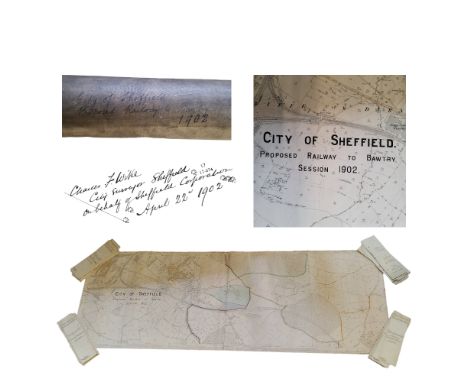
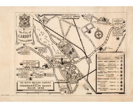
Cardiff. Baker (L. A.), The City of Cardiff Capital of Wales. The Sixth Empire and Commonwealth Games, Wales, 1958, pen and ink map of the city on draughtsmen's opaque tracing paper, with a key plate showing the venues for various sporting events, slight staining, artist's monogram to the lower right, old pin holes in the corners of the map but not affecting the painted image, 405 x 545 mm, overall size 480 x 660 mm, together with City of Cardiff. Guide to Places of Interest, circa 1958, pen and ink map of the city on draughtsmen's opaque tracing paper, signed by the artist to the lower right, slight staining and creasing, trimmed with some loss to the neatline, 620 x 630 mm, with Roberts (E. C. M. Eng. City Surveyor). Wood Street Car Park, City of Cardiff, circa 1958, pen and ink frontal elevation and view by L. A. Baker on draughtsmen's opaque tracing paper, signed by the artist to the lower right, slight marginal staining, 185 x 420 mmQTY: (3)
Lot 146
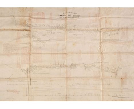
Sudan. Fowler (John, surveyor), Sketch of the Country between Ambukol and Shendy, Taken from the Survey of Mr John Fowler C. E. to which is added Descriptive Notes of the Route, Intelligence Branch, War Office, May 1884, lithographic linear map, printed in red and black on linen, some staining, old folds, 680 x 1000 mm, together with Sketch Map of Country between Suakin and Berber with noted on the Principal Routes, Intelligence Branch War Office, under the direction of Major W. R. Fox ..., June 1884, lithographic linear map, printed in red and black on silk, very slight staining, old folds, 480 x 720 mm, with Map of the Nile Provinces from the Railway Terminus at Siût to Berber, Compiled in the Intelligence Branch, War Office, 1884, lithographic map, printed in brown and black on silk, slight staining, old folds, 1060 x 650 mm, plus Sketch Map of Nile from Wady Halfa to Khartum with noted on Caravan Routes, Navigability of Nile, Towns, Climate &c. Intelligence Branch, War Office, May 1884, lithographic linear map, printed in red and black on linen, with contemporary printed paper label of distances along the Nile, printed in red and pinned to the left-hand margin, some staining, old folds, 780 x 635 mmQTY: (4)NOTE:In the lower-left corner of the first described map is a printed note. The Information given in red on this map is quite correct and is obtained from the studies of the Soudan Railway Survey of 1872 of which I was second in charge. W. Whitworth Sept. 10th 1884. There is a later state of this map (held by the National Library of Australia), with an addition to the title which states Revised from Sketches and Information furnished by Officers during the Campaign of 1884 - 1885. This would coincide with the siege of Khartoum and the death of General Gordon. Gordon arrived at Khartoum on 18 February 1884 and the siege took place between the 13 March 1884 and the 26 January 1885. The Mahdists hearing news of an approaching British relief column, stormed the garrison slaughtering the defenders to the last man, as well as 4,000 of the town's male inhabitants. Many of the surviving women and children were enslaved by the victorious Mahdists. Advance elements of the relief expedition arrived within sight of Khartoum two days after it fell. After discovering that they were too late, the surviving British and Egyptian troops withdrew. It is therefore possible that these maps - designed for portability - were used by British officers in the relief column.
Lot 92
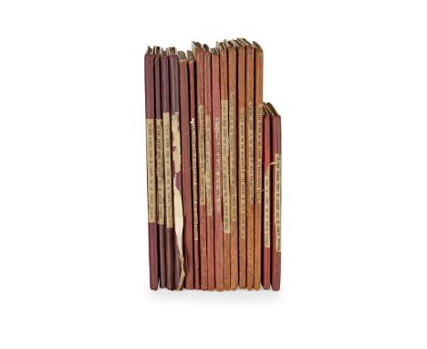
India General Report on the Operations of the Survey of India Administered under the Government of India during 1908-9 [-1923-24]. Calcutta: Superintendent Government Printing, India [-printed at the Photo.-Litho. Office, Survey of India], 1910-25. 16 volumes, volumes 1-14 folio, 15-16 8vo, original cloth-backed printed boards, printed cloth labels to spines, numerous folding lithographic maps and plans, colour frontispiece reproducing a medallion portrait of Major James Jennell to volume for 1908-9, photogravure portrait frontispiece of Colonel Charles Henry Dudley Ryder, Surveyor-General to volume for 1923-24 ex-Manchester Public Libraries with bookplates and labels to front pastedowns, ink-stamps to versos of maps and plans, cancellation stamps to front free endpapers, collation slips tipped in at rear, occasional blind stamps to covers, lending slip to front free endpaper of volume for 1923-24, volume for 1914-15 with front free endpaper removed, volume for 1921-22 spine-label coming loose (16) An unbroken run. Rare in commerce.


Lot 630
Two manuscript maps of the fortifications around Oudeschans (previously known as Bellingwolderschans) and Lieroord, 18.5 x 28 cm and 17.8 x 27.5, both monogrammed and dated "Mense Febr(uar) 1648", numb. LXXVIII and LXXIX in pen, both on paper w. fools cap watermark, under passepartouts. Oudewater plan vaguely waterst. in left half. Johann Merck was a German military surveyor who worked in the Netherlands from 1643 to 1649, and he made the preparatory drawings for Theatrum Europaeum and Topographia Germania Inferioris, published by Matthäus and Caspar Merian. Provenance: The original manuscript atlas this leaf was taken from was entitled 'Festina Lente', and it contained 124 fortification plans by Merck. It was unfortunately broken up. See the Beijers book auction, Utrecht, 25-26 March 1981, lot number 1436. The present auction offers a total of 21 plans from that atlas. Cf. P.M. Meurer, Der Geldern-Plan des Johann Merck aus dem Jahre 1646. Ein Schlüsselwerk für eine Neudatierung der Festungspläne Gelderns im 17. Jahrhunderts, in Geldrischer Heimatkalender, 2001, pages 198-207.
Lot 631
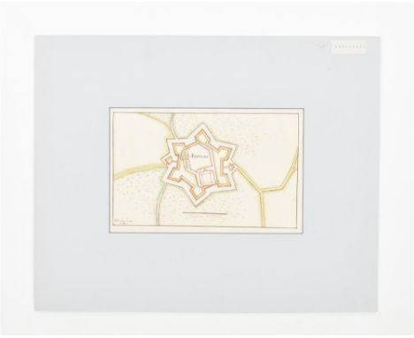
Manuscript map of the fortifications of Bredevoort, 16.5 x 26.8 cm, monogrammed, dated 'Mense Januar 1648' and numb. 'LXX' in pen, on paper w. fools cap watermark, under passepartout. Johann Merck was a German military surveyor who worked in the Netherlands from 1643 to 1649, and he made the preparatory drawings for Theatrum Europaeum and Topographia Germania Inferioris, published by Matthäus and Caspar Merian. Provenance: The original manuscript atlas this leaf was taken from was entitled 'Festina Lente', and it contained 124 fortification plans by Merck. It was unfortunately broken up. See the Beijers book auction, Utrecht, 25-26 March 1981, lot number 1436. The present auction offers a total of 21 plans from that atlas. Cf. P.M. Meurer, Der Geldern-Plan des Johann Merck aus dem Jahre 1646. Ein Schlüsselwerk für eine Neudatierung der Festungspläne Gelderns im 17. Jahrhunderts, in Geldrischer Heimatkalender, 2001, pages 198-207.
Lot 632
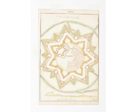
Manuscript map of the intricate fortifications of Coevorden, 16.5 x 26.8 cm, monogrammed, dated "Mens. Feb. 1648" and numb. LXXVI in pen, on paper w. fools cap watermark, under passepartout. Johann Merck was a German military surveyor who worked in the Netherlands from 1643 to 1649, and he made the preparatory drawings for Theatrum Europaeum and Topographia Germania Inferioris, published by Matthäus and Caspar Merian. Provenance: The original manuscript atlas this leaf was taken from was entitled 'Festina Lente', and it contained 124 fortification plans by Merck. It was unfortunately broken up. See the Beijers book auction, Utrecht, 25-26 March 1981, lot number 1436. The present auction offers a total of 21 plans from that atlas. Cf. P.M. Meurer, Der Geldern-Plan des Johann Merck aus dem Jahre 1646. Ein Schlüsselwerk für eine Neudatierung der Festungspläne Gelderns im 17. Jahrhunderts, in Geldrischer Heimatkalender, 2001, pages 198-207.

Lot 633
Manuscript map of the fortifications, 19 x 29.5 cm, monogrammed and dated "Mens Januar 1648", numb. LXIX in pen, on paper w. fools cap watermark, under passepartout. -and 2 other manuscript maps from the same atlas, dep. "Schans de Vooren" (numb. XXVI) and "Hemmert" (numb. XXXI), both under passepartout. Johann Merck was a German military surveyor who worked in the Netherlands from 1643 to 1649, and he made the preparatory drawings for Theatrum Europaeum and Topographia Germania Inferioris, published by Matthäus and Caspar Merian. Provenance: The original manuscript atlas this leaf was taken from was entitled 'Festina Lente', and it contained 124 fortification plans by Merck. It was unfortunately broken up. See the Beijers book auction, Utrecht, 25-26 March 1981, lot number 1436. The present auction offers a total of 21 plans from that atlas. Cf. P.M. Meurer, Der Geldern-Plan des Johann Merck aus dem Jahre 1646. Ein Schlüsselwerk für eine Neudatierung der Festungspläne Gelderns im 17. Jahrhunderts, in Geldrischer Heimatkalender, 2001, pages 198-207.

Lot 634
Two manuscript maps of the fortifications around Leerdam and Asperen, both 17 x 27 cm, monogrammed, and dated "Mense Aug. 1649", numb. CXV and CXVII in pen, Asperen on paper w. watermark in the shape of a deer, under passepartouts. Johann Merck was a German military surveyor who worked in the Netherlands from 1643 to 1649, and he made the preparatory drawings for Theatrum Europaeum and Topographia Germania Inferioris, published by Matthäus and Caspar Merian. Provenance: The original manuscript atlas this leaf was taken from was entitled 'Festina Lente', and it contained 124 fortification plans by Merck. It was unfortunately broken up. See the Beijers book auction, Utrecht, 25-26 March 1981, lot number 1436. The present auction offers a total of 21 plans from that atlas. Cf. P.M. Meurer, Der Geldern-Plan des Johann Merck aus dem Jahre 1646. Ein Schlüsselwerk für eine Neudatierung der Festungspläne Gelderns im 17. Jahrhunderts, in Geldrischer Heimatkalender, 2001, pages 198-207.

Lot 635
Manuscript map of the fortifications of the main buildings of the Wallonian city Limbourg, 17.5 x 28.8 cm, monogrammed, dated "Mens. Mart. 1646" and numb. XVII, legend listing 7 buildings and historical annotations in pen, under passepartout. Johann Merck was a German military surveyor who worked in the Netherlands from 1643 to 1649, and he made the preparatory drawings for Theatrum Europaeum and Topographia Germania Inferioris, published by Matthäus and Caspar Merian. Provenance: The original manuscript atlas this leaf was taken from was entitled 'Festina Lente', and it contained 124 fortification plans by Merck. It was unfortunately broken up. See the Beijers book auction, Utrecht, 25-26 March 1981, lot number 1436. The present auction offers a total of 21 plans from that atlas. Cf. P.M. Meurer, Der Geldern-Plan des Johann Merck aus dem Jahre 1646. Ein Schlüsselwerk für eine Neudatierung der Festungspläne Gelderns im 17. Jahrhunderts, in Geldrischer Heimatkalender, 2001, pages 198-207.

Lot 636
Manuscript maps of the fortifications around castle Loevestein, 28.3 x 17.3 cm, monogrammed, dated "Mens. April. (16)46" and numb. XXXIII in pen, on paper w. fools cap watermark, under passepartout. Johann Merck was a German military surveyor who worked in the Netherlands from 1643 to 1649, and he made the preparatory drawings for Theatrum Europaeum and Topographia Germania Inferioris, published by Matthäus and Caspar Merian. Provenance: The original manuscript atlas this leaf was taken from was entitled 'Festina Lente', and it contained 124 fortification plans by Merck. It was unfortunately broken up. See the Beijers book auction, Utrecht, 25-26 March 1981, lot number 1436. The present auction offers a total of 21 plans from that atlas. Cf. P.M. Meurer, Der Geldern-Plan des Johann Merck aus dem Jahre 1646. Ein Schlüsselwerk für eine Neudatierung der Festungspläne Gelderns im 17. Jahrhunderts, in Geldrischer Heimatkalender, 2001, pages 198-207.

Lot 637
Three manuscript maps of the fortifications around Oostburg, IJzendijke and Biervliet, all approx. 18 x 29 cm, monogrammed and dated January 1647, numb. LX, LIX and LVII in pen, two plans on paper w. fools cap watermark, under passepartouts. Oostburg plan w. a legend listing 6 areas numb. on the map. Johann Merck was a German military surveyor who worked in the Netherlands from 1643 to 1649, and he made the preparatory drawings for Theatrum Europaeum and Topographia Germania Inferioris, published by Matthäus and Caspar Merian. Provenance: The original manuscript atlas this leaf was taken from was entitled 'Festina Lente', and it contained 124 fortification plans by Merck. It was unfortunately broken up. See the Beijers book auction, Utrecht, 25-26 March 1981, lot number 1436. The present auction offers a total of 21 plans from that atlas. Cf. P.M. Meurer, Der Geldern-Plan des Johann Merck aus dem Jahre 1646. Ein Schlüsselwerk für eine Neudatierung der Festungspläne Gelderns im 17. Jahrhunderts, in Geldrischer Heimatkalender, 2001, pages 198-207.

Lot 638
Manuscript map of the fortifications of St. Martin, 18 x 28.8 cm, monogrammed, dated "Mens. Iobris. 1646" and numb. XLIV in pen, on paper w. fools cap watermark, under passepartout. With annotations in pen: "A. De oude vaart bij den viant gegraven. B. De oude vaert daer door den viant op stroom quam." Johann Merck was a German military surveyor who worked in the Netherlands from 1643 to 1649, and he made the preparatory drawings for Theatrum Europaeum and Topographia Germania Inferioris, published by Matthäus and Caspar Merian. Provenance: The original manuscript atlas this leaf was taken from was entitled 'Festina Lente', and it contained 124 fortification plans by Merck. It was unfortunately broken up. See the Beijers book auction, Utrecht, 25-26 March 1981, lot number 1436. The present auction offers a total of 21 plans from that atlas. Cf. P.M. Meurer, Der Geldern-Plan des Johann Merck aus dem Jahre 1646. Ein Schlüsselwerk für eine Neudatierung der Festungspläne Gelderns im 17. Jahrhunderts, in Geldrischer Heimatkalender, 2001, pages 198-207.

Lot 639
Two manuscript maps of the fortifications around Gouda and Oudewater, 17.3 x 27.5 and 16.1 x 26.5 cm, both monogrammed and dated "Mense Aug. 1649", numb. CIX and CX in pen, Oudewater on paper w. watermark in the shape of a deer, under passepartouts, Gouda mounted on cardboard. Johann Merck was a German military surveyor who worked in the Netherlands from 1643 to 1649, and he made the preparatory drawings for Theatrum Europaeum and Topographia Germania Inferioris, published by Matthäus and Caspar Merian. Provenance: The original manuscript atlas this leaf was taken from was entitled 'Festina Lente', and it contained 124 fortification plans by Merck. It was unfortunately broken up. See the Beijers book auction, Utrecht, 25-26 March 1981, lot number 1436. The present auction offers a total of 21 plans from that atlas. Cf. P.M. Meurer, Der Geldern-Plan des Johann Merck aus dem Jahre 1646. Ein Schlüsselwerk für eine Neudatierung der Festungspläne Gelderns im 17. Jahrhunderts, in Geldrischer Heimatkalender, 2001, pages 198-207.

Lot 640
Manuscript map of the fortifications of Utrecht, 18.3 x 30 cm, monogrammed, dated 'Mense Februar ao. 1658' and numb. 'CXXII' in pen, under passepartout. Johann Merck was a German military surveyor who worked in the Netherlands from 1643 to 1649, and he made the preparatory drawings for Theatrum Europaeum and Topographia Germania Inferioris, published by Matthäus and Caspar Merian. Provenance: The original manuscript atlas this leaf was taken from was entitled 'Festina Lente', and it contained 124 fortification plans by Merck. It was unfortunately broken up. See the Beijers book auction, Utrecht, 25-26 March 1981, lot number 1436. The present auction offers a total of 21 plans from that atlas. Cf. P.M. Meurer, Der Geldern-Plan des Johann Merck aus dem Jahre 1646. Ein Schlüsselwerk für eine Neudatierung der Festungspläne Gelderns im 17. Jahrhunderts, in Geldrischer Heimatkalender, 2001, pages 198-207.
Lot 641
Three manuscript maps of the fortifications around Vlissingen, Cadzand/ Stern Schans and Saaftinge, all approx. 18 x 29 cm, monogrammed and dated January 1648, numb. LXV, LXIV and L in pen, all on paper w. fools cap watermark, under passepartouts. Johann Merck was a German military surveyor who worked in the Netherlands from 1643 to 1649, and he made the preparatory drawings for Theatrum Europaeum and Topographia Germania Inferioris, published by Matthäus and Caspar Merian. Provenance: The original manuscript atlas this leaf was taken from was entitled 'Festina Lente', and it contained 124 fortification plans by Merck. It was unfortunately broken up. See the Beijers book auction, Utrecht, 25-26 March 1981, lot number 1436. The present auction offers a total of 21 plans from that atlas. Cf. P.M. Meurer, Der Geldern-Plan des Johann Merck aus dem Jahre 1646. Ein Schlüsselwerk für eine Neudatierung der Festungspläne Gelderns im 17. Jahrhunderts, in Geldrischer Heimatkalender, 2001, pages 198-207.
Lot 2682
INDIA - DURY, ANDREW AN ACTUAL SURVEY OF THE PROVINCES OF BENGAL, BAHAR &c. BY MAJOR JAMES RENNELL, ENGINEER Surveyor General to the Honourable East India Company, Published by Permission of the Court of Directors from a Drawing in their Possession 1776, upper portion only, large engraved map with outline hand-colouring, framed under glass and measuring approx. 152cm x 58cm externally Condition Report:Available upon request
Lot 108
Ireland & Scotland.- House of Commons. A list of the members of the Hon. House of Commons of Ireland, who voted on the question previous to the expulsion of Arthur Jones Nevill, Esq; late engineer and surveyor-general of that kingdom, broadside, trimmed, folds, some spotting, lightly browned, 470 x 270mm., London [?but Dublin], Printed by Robert Scot, 1753 § Scottish clans.- A genuine alphabetical list of all the known clans of Scotland, with a description of the particular badges of distinction anciently worn by each clan respectively, and the distinguishing mark of their Chiefs, broadside, wood-engraved decorative border, a few paper flaws, just touching part of the odd letter, little spotting or staining, lightly browned, 248 x 208mm., [Edinburgh], R. Menzies, printer, [c. 1815]; and 7 others, Irish & Scottish interest, v.s (9) *** I: In 1743, Jones-Nevill purchased the office of Surveyor-General of Ireland for £3,300. He was dismissed from the post in 1752 following accusations of maladministration, having failed to deal with the upkeep of Ireland's barracks. The affair rumbled on until November, 1753, when he was expelled from Parliament.
Lot 76
London, Whitechapel.- Manning (Joseph, surveyor) A Plan of an Estate situate in the Parish of St Mary White Chapel belonging to Messrs. Buckley Esqrs., pen and ink and watercolour plan, on vellum, watercolour coat of arms, soiled, lower edge with creases, framed and glazed, plan 270 x 780mm., 1747.
-
1529 item(s)/page