No Image Lot 1063 1935-36 Ordnance Survey Office Map Southampton with Brentford Old Football Stadium, Griffin Park 10631935-36 Ordnance Survey Office Map Southampton with Brentford Old Football Stadium, Griffin Park Mullock Jones 1935-36 Ordnance Survey Office Map Southampton with Brentford Old Football Stadium, Griffin Park included. Has been kept rolled up, displays well,... Add to watchlist Live
No Image Lot 2078 A copper coal scuttle, a box of Ordnance survey maps, a galvanised one gallon watering can, and a 2078A copper coal scuttle, a box of Ordnance survey maps, a galvanised one gallon watering can, and a Golding Young & Mawer A copper coal scuttle, a box of Ordnance survey maps, a galvanised one gallon watering can, and a log basket. Add to watchlist Tender
No Image Lot 39 COLLECTION OF ORDNANCE SURVEY MAPS Provenance: private collection Cheshire 39COLLECTION OF ORDNANCE SURVEY MAPS Provenance: private collection Cheshire Rogers Jones & Co COLLECTION OF ORDNANCE SURVEY MAPS Provenance: private collection Cheshire Add to watchlist Live
No Image Lot 693 A box containing a quantity of Ordnance Survey and road maps 693A box containing a quantity of Ordnance Survey and road maps Rendells Auctioneers & Estate Agents A box containing a quantity of Ordnance Survey and road maps Add to watchlist Live
No Image Lot 1867 A box containing vintage road maps and Ordnance Survey maps including a few linen backed examples, 1867A box containing vintage road maps and Ordnance Survey maps including a few linen backed examples, Rendells Auctioneers & Estate Agents A box containing vintage road maps and Ordnance Survey maps including a few linen backed examples, etc. Add to watchlist Live
No Image Lot 1034 A Quantity Of Sheffield Related Items, to include Sheffield Corporation And British Railways Tramway 1034A Quantity Of Sheffield Related Items, to include Sheffield Corporation And British Railways Tramway Sheffield Auction Gallery A Quantity Of Sheffield Related Items, to include Sheffield Corporation And British Railways Tramway & Omnibus Time Table 1958, Sheffield Transpor... Add to watchlist Live
No Image Lot 1209 Ephemera. A large collection of vintage and other world maps, atlas books, ordnance touring maps and 1209Ephemera. A large collection of vintage and other world maps, atlas books, ordnance touring maps and JS Fine Art Auctioneers & Valuers Ephemera. A large collection of vintage and other world maps, atlas books, ordnance touring maps and rolled maps. Add to watchlist Live
No Image Lot 1694 A collection of Ordnance Survey local maps 1694A collection of Ordnance Survey local maps JS Fine Art Auctioneers & Valuers A collection of Ordnance Survey local maps Add to watchlist Live
No Image Lot 414 A small collection of military ordnance survey maps together with some civilian examples. 414A small collection of military ordnance survey maps together with some civilian examples. Wessex Auction Rooms A small collection of military ordnance survey maps together with some civilian examples. Add to watchlist Live
Reserve not met No Image Lot 1305 Local interest* A pictorial map of Ulverston, monochrome with some lightly coloured areas, printed 1305Local interest* A pictorial map of Ulverston, monochrome with some lightly coloured areas, printed 1818 Auctioneers Local interest* A pictorial map of Ulverston, monochrome with some lightly coloured areas, printed by Reminder press for The Furness Tourism Partn... Add to watchlist Timed
Reserve not met No Image Lot 56 HOBSON, William Colling: 56HOBSON, William Colling: Sworders Timed HOBSON, William Colling: Hobson's Fox-Hunting Atlas; containing separate Map of Every County in England, and the Three Ridings of Yorkshire; compr... Add to watchlist Timed
No Image Lot 123 Maps & Ephemera, early 20th Century 123Maps & Ephemera, early 20th Century Chorley's Maps & Ephemera, early 20th Century to include Bartholomew (J. G.) The Pocket Atlas and Guide to London, 1893; Coplow (Billesdon) A Poem on Fox Hu... Add to watchlist Live
No Image Lot 127 Various WWII Ordnance Survey RAF maps 127Various WWII Ordnance Survey RAF maps Chorley's Various WWII Ordnance Survey RAF maps War Office: 1942, various editions to include Rome, Florence, Lyon, Naples, Marseille, Nice, Paris, Strait o... Add to watchlist Live
No Image Lot 206 Large quantity of Ordnance Survey and other maps 206Large quantity of Ordnance Survey and other maps Lawrences of Bletchingley Large quantity of Ordnance Survey and other maps Add to watchlist Live
No Image Lot 230 A collection of 1920’s Ordnance Survey maps of Great Britain - seven of Scotland and twelve 230A collection of 1920’s Ordnance Survey maps of Great Britain - seven of Scotland and twelve Lindsay Burns & Company A collection of 1920’s Ordnance Survey maps of Great Britain - seven of Scotland and twelve England & Wales, in leather carrying case by E. Stanfo... Add to watchlist Live
No Image Lot 250 A wicker hamper containing a large quantity of Ordnance Survey maps 250A wicker hamper containing a large quantity of Ordnance Survey maps Thomas N. Miller A wicker hamper containing a large quantity of Ordnance Survey maps Add to watchlist Live
No Image Lot 288 A wicker hamper and canvas luggage case containing militaria including frame prints, canteen, torch, 288A wicker hamper and canvas luggage case containing militaria including frame prints, canteen, torch, Thomas N. Miller A wicker hamper and canvas luggage case containing militaria including frame prints, canteen, torch, morse code tapper, headset, canvas bags and c... Add to watchlist Live
No Image Lot 444 A quantity of car magazines, ordnance survey maps, etc. 444A quantity of car magazines, ordnance survey maps, etc. Thomas N. Miller A quantity of car magazines, ordnance survey maps, etc. (1 box) Add to watchlist Live
No Image Lot 820 Great Britain FDC 1991 (Sept 17th) Maps set on Ordnance Survey Bicentenary FDC with H/S 820Great Britain FDC 1991 (Sept 17th) Maps set on Ordnance Survey Bicentenary FDC with H/S James & Sons Auctioneers Great Britain FDC 1991 (Sept 17th) Maps set on Ordnance Survey Bicentenary FDC with H/S Add to watchlist Live
No Image Lot 160 AN ORDNANCE SURVEY MAP OF KNOCKLOFTY ESTATE, CO. WATERFORD, 1908 linen backed fold-out map, 160AN ORDNANCE SURVEY MAP OF KNOCKLOFTY ESTATE, CO. WATERFORD, 1908 linen backed fold-out map, Adams AN ORDNANCE SURVEY MAP OF KNOCKLOFTY ESTATE, CO. WATERFORD, 1908 linen backed fold-out map, there is one fold-out in 37 sections, with hand writt... Add to watchlist Live
Reserve not met No Image Lot 235 Quantity of various One-Inch & Ordnance Survey maps - various places in the UK ALL USED UNCHECKED 235Quantity of various One-Inch & Ordnance Survey maps - various places in the UK ALL USED UNCHECKED Cato Crane Auctioneers Quantity of various One-Inch & Ordnance Survey maps - various places in the UK ALL USED UNCHECKED Add to watchlist Timed
No Image Lot 168 Sampson (Rev. Geo. V.) A Memoir, Explanatory of the Chart and Survey of the County of London- 168Sampson (Rev. Geo. V.) A Memoir, Explanatory of the Chart and Survey of the County of London- Fonsie Mealy Auctioneers Sampson (Rev. Geo. V.) A Memoir, Explanatory of the Chart and Survey of the County of London-Derry, Ireland, Folio Lond. 1814. First Edn., list of... Add to watchlist Live
No Image Lot 222 Collection of 24 Volumes Co. Kildare: Ordnance Survey Letters, - Kildare, 4to Dublin 2002; 222Collection of 24 Volumes Co. Kildare: Ordnance Survey Letters, - Kildare, 4to Dublin 2002; Fonsie Mealy Auctioneers Collection of 24 Volumes Co. Kildare: Ordnance Survey Letters, - Kildare, 4to Dublin 2002; Simington (R.C.)ed. The Civil Survey 1654-1656, Co. K... Add to watchlist Live
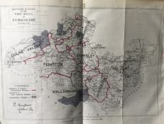
Reserve not met No Image Lot 12 Antique 139 Years-Old Scarce Map South West Riding Yorkshire 1885 12Antique 139 Years-Old Scarce Map South West Riding Yorkshire 1885 William George Title: Antique 139 Years-Old Scarce Map South West Riding Yorkshire 1885Description: Zincographed Ordnance Survey Map Produced by Colonel R. ... Add to watchlist Timed
Reserve not met No Image Lot 100 Antique 139 Years-Old Scarce Map County of Devon 1885 Boundary Changes. 100Antique 139 Years-Old Scarce Map County of Devon 1885 Boundary Changes. William George Title: Antique 139 Years-Old Scarce Map County of Devon 1885 Boundary Changes.Description: Antique 139 Years-Old Scarce Map County of Devon 1... Add to watchlist Timed
Reserve not met No Image Lot 112 Antique 139 Years-Old Scarce Map County Essex 1885 Boundary Changes. 112Antique 139 Years-Old Scarce Map County Essex 1885 Boundary Changes. William George Title: Antique 139 Years-Old Scarce Map County Essex 1885 Boundary Changes.Description: Antique 139 Years-Old Scarce Map County Essex 1885 Bo... Add to watchlist Timed
Reserve not met No Image Lot 120 Antique 139 Years-Old Scarce Map Stoke On Trent 1885 Boundary Changes. 120Antique 139 Years-Old Scarce Map Stoke On Trent 1885 Boundary Changes. William George Title: Antique 139 Years-Old Scarce Map Stoke On Trent 1885 Boundary Changes.Description: Antique 139 Years-Old Scarce Map Stoke On Trent 188... Add to watchlist Timed
Reserve not met No Image Lot 126 Antique 139 Years-Old Scarce Map Lincolnshire 1885 Boundary Changes. 126Antique 139 Years-Old Scarce Map Lincolnshire 1885 Boundary Changes. William George Title: Antique 139 Years-Old Scarce Map Lincolnshire 1885 Boundary Changes.Description: Antique 139 Years-Old Scarce Map Lincolnshire 1885 Bo... Add to watchlist Timed
Reserve not met No Image Lot 127 Antique 139 Years-Old Scarce Map City of Bradford 1885 Boundary Changes. 127Antique 139 Years-Old Scarce Map City of Bradford 1885 Boundary Changes. William George Title: Antique 139 Years-Old Scarce Map City of Bradford 1885 Boundary Changes.Description: Antique 139 Years-Old Scarce Map City of Bradford... Add to watchlist Timed
Reserve not met No Image Lot 128 Antique 139 Years-Old Scarce Map South West Riding Yorkshire 1885 Boundary Changes. 128Antique 139 Years-Old Scarce Map South West Riding Yorkshire 1885 Boundary Changes. William George Title: Antique 139 Years-Old Scarce Map South West Riding Yorkshire 1885 Boundary Changes.Description: Zincographed Ordnance Survey Map Produ... Add to watchlist Timed
Reserve not met No Image Lot 129 Antique 139 Years-Old Scarce Map North West Riding Yorkshire 1885 Boundary Change 129Antique 139 Years-Old Scarce Map North West Riding Yorkshire 1885 Boundary Change William George Title: Antique 139 Years-Old Scarce Map North West Riding Yorkshire 1885 Boundary ChangeDescription: Zincographed Ordnance Survey Map Produce... Add to watchlist Timed
Reserve not met No Image Lot 131 Antique 139 Years-Old Scarce Map County of Middlesex & London 1885 Boundary Changes. 131Antique 139 Years-Old Scarce Map County of Middlesex & London 1885 Boundary Changes. William George Title: Antique 139 Years-Old Scarce Map County of Middlesex & London 1885 Boundary Changes.Description: Antique 139 Years-Old Scarce Map Coun... Add to watchlist Timed
Reserve not met No Image Lot 137 Antique 139 Years-Old Scarce Map City of Reading 1885 Boundary Changes. 137Antique 139 Years-Old Scarce Map City of Reading 1885 Boundary Changes. William George Title: Antique 139 Years-Old Scarce Map City of Reading 1885 Boundary Changes.Description: Antique 139 Years-Old Scarce Map City of Reading 1... Add to watchlist Timed
Reserve not met No Image Lot 139 Antique 139 Years-Old Scarce Map of Bedfordshire Boundary Changes 1885. 139Antique 139 Years-Old Scarce Map of Bedfordshire Boundary Changes 1885. William George Title: Antique 139 Years-Old Scarce Map of Bedfordshire Boundary Changes 1885.Description: Antique 139 Years-Old Scarce Map of Bedfordshire ... Add to watchlist Timed
Reserve not met No Image Lot 140 Antique 139 Years-Old Scarce Coloured Map Lake District 1885 Boundary Changes. 140Antique 139 Years-Old Scarce Coloured Map Lake District 1885 Boundary Changes. William George Title: Antique 139 Years-Old Scarce Coloured Map Lake District 1885 Boundary Changes.Description: Antique 139 Years-Old Scarce Map Lake Distr... Add to watchlist Timed
Reserve not met No Image Lot 141 Antique 139 Years-Old Scarce Map Lake District Cumbria 1885 Boundary Changes. 141Antique 139 Years-Old Scarce Map Lake District Cumbria 1885 Boundary Changes. William George Title: Antique 139 Years-Old Scarce Map Lake District Cumbria 1885 Boundary Changes.Description: Antique 139 Years-Old Scarce Map Cumbria 188... Add to watchlist Timed
Reserve not met No Image Lot 148 Antique 139 Years-Old Scarce Map Buckinghamshire 1885 Boundary Changes. 148Antique 139 Years-Old Scarce Map Buckinghamshire 1885 Boundary Changes. William George Title: Antique 139 Years-Old Scarce Map Buckinghamshire 1885 Boundary Changes.Description: Antique 139 Years-Old Scarce Map Buckinghamshire 1... Add to watchlist Timed
Reserve not met No Image Lot 169 Antique 139 Years-Old Scarce Map Denbighshire 1885 Boundary Changes. 169Antique 139 Years-Old Scarce Map Denbighshire 1885 Boundary Changes. William George Title: Antique 139 Years-Old Scarce Map Denbighshire 1885 Boundary Changes.Description: Antique 139 Years-Old Scarce Map Denbighshire 1885 Bo... Add to watchlist Timed
Reserve not met No Image Lot 170 Antique 139 Years-Old Scarce Map Carmarthenshire 1885 Boundary Changes. 170Antique 139 Years-Old Scarce Map Carmarthenshire 1885 Boundary Changes. William George Title: Antique 139 Years-Old Scarce Map Carmarthenshire 1885 Boundary Changes.Description: Antique 139 Years-Old Scarce Map Carmarthenshire 1... Add to watchlist Timed
Reserve not met No Image Lot 187 Antique 139 Years-Old Scarce Map Northamptonshire 1885 Boundary Changes. 187Antique 139 Years-Old Scarce Map Northamptonshire 1885 Boundary Changes. William George Title: Antique 139 Years-Old Scarce Map Northamptonshire 1885 Boundary Changes.Description: Antique 139 Years-Old Scarce Map Northamptonshire... Add to watchlist Timed
Reserve not met No Image Lot 190 Antique 139 Years-Old Scarce Map Cheltenham 1885 Boundary Changes. 190Antique 139 Years-Old Scarce Map Cheltenham 1885 Boundary Changes. William George Title: Antique 139 Years-Old Scarce Map Cheltenham 1885 Boundary Changes.Description: Antique 139 Years-Old Scarce Map Cheltenham 1885 Bounda... Add to watchlist Timed
Reserve not met No Image Lot 120 A large quantity of early 20th century Ordnance Survey maps, to include Carmarthen, St. David's & 120A large quantity of early 20th century Ordnance Survey maps, to include Carmarthen, St. David's & 1818 Auctioneers A large quantity of early 20th century Ordnance Survey maps, to include Carmarthen, St. David's & Cardigan, Brecon & Llandovery, Abergavenny, Glou... Add to watchlist Timed
Reserve not met No Image Lot 132 Two boxes containing various vintage Ordnance Survey maps, to include Loch Lomond, Bradford, 132Two boxes containing various vintage Ordnance Survey maps, to include Loch Lomond, Bradford, 1818 Auctioneers Two boxes containing various vintage Ordnance Survey maps, to include Loch Lomond, Bradford, Bolton ect, over 100 Add to watchlist Timed
Reserve not met No Image Lot 170 A group of 7 blue binders holding various ordnance survey maps of Great Britain, (7) 170A group of 7 blue binders holding various ordnance survey maps of Great Britain, (7) 1818 Auctioneers A group of 7 blue binders holding various ordnance survey maps of Great Britain, (7) Add to watchlist Timed
Reserve not met No Image Lot 190 Two boxes containing various Ordnance Survey maps of the UK, to include Preston and Blackpool, 190Two boxes containing various Ordnance Survey maps of the UK, to include Preston and Blackpool, 1818 Auctioneers Two boxes containing various Ordnance Survey maps of the UK, to include Preston and Blackpool, Askrigg & Settle and Selkirk, over 100 maps Add to watchlist Timed
No Image Lot 303 A PAIR OF ORDNANCE SURVEY BLACK AND WHITE MAPS OF LONDON Numbered TQ2477 and TQ2577 and TQ2476 and 303A PAIR OF ORDNANCE SURVEY BLACK AND WHITE MAPS OF LONDON Numbered TQ2477 and TQ2577 and TQ2476 and Swan Fine Art A PAIR OF ORDNANCE SURVEY BLACK AND WHITE MAPS OF LONDON Numbered TQ2477 and TQ2577 and TQ2476 and TQ 2577, framed and glazed. (approx 86cm x 60cm... Add to watchlist Live